The forecasts at various weather sites were varied, but some gave hope of partly sunny skies with just a few isolated showers. With that in mind, I drove over to the Pinkham Notch area, passing through dreary drizzle in Franconia Notch but encountering sun and partial views once north of the notch. Things were nice and dry as I set off up Nineteen Mile Brook Trail, headed for the Carter Notch area. My primary objective was to bushwhack to a remnant open rock slab from a large slide that fell on the SW side of Carter Dome in 1869. This slide was descended by a trio of AMC explorers in 1876, coming down from the summit of then-trailless Carter Dome. I also hoped to check out the slide crossing on Wildcat Ridge Trail and drop down to Upper Carter Pond in Carter Notch.
In its first mile the trail passes some nice cascades on Nineteen Mile Brook.
A landmark along the trail is the dam and pool at 1.2 miles. Historically this has been used as a water supply for the various versions of the Glen House hotel.
Nineteen Mile Brook, not far before the junction with the Carter Dome Trail. About here the first rain shower moved in. So much for the partial sun.
Cascade at the crossing of the brook that drains the big 1960s slide on the NW flank of Carter Dome.
My last few trips up this trail have been in winter. I'd forgotten how bloody rocky this heavily used route is.
This is the third brook crossed after the Carter Dome Trail junction. A massive rainstorm in October 1869 - the same storm that caused the first South Slide on Mt. Tripyramid - triggered a large slide in this drainage on the SW slope of Carter Dome. The track of the slide swept all the way down to Nineteen Mile Brook. Downstream from the slide there was major flooding of the Peabody River, and in that flood J.M. Thompson, proprietor of the Glen House hotel, was drowned while trying to save his mill from destruction.
The woods were now soaking wet, but I decided I would still attempt the 0.15 mile whack to the open rock slab on the old slide track, as long as the undergrowth wasn't too dense. As luck would have it, the woods on the approach were open, though it became much thicker and steeper as I neared the bottom of the slab.
I went over to check out this nice cascade on the brook/slide track.
After maneuvering through some steep and tight terrain, I traversed a narrow shelf along the base of the slab, from which I could look down at the track below, long since revegetated with moss and scrubby trees.
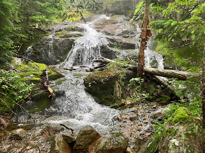
Here the stream - a major branch of Nineteen Mile Brook - slides down a long cascade.
Above, it spills down the big slab as a lofty waterfall.
A wider view.
From here, I made a gnarly whack up through the woods along the left side of the slab, popping out to the edge for a look partway up.
This is a big slab of rock, 150 feet long and up to 70 feet wide. Steep and soaking wet. No way I was going out on that rock today.
Down-look.
As noted above, this slide provided an
exciting descent route from the summit of Carter Dome for a trio of AMC explorers - William Nowell,
guide Charles Lowe and Dr. F.I.R. Stafford - in 1876. In his account of
the trip in Appalachia, Nowell reported his measurements of the slide,
which had a maximum slope of 42 degrees in both its upper and lower
sections. He estimated that 20 acres of rock, soil and forest growth had
been stripped away. The lower part was mostly “perfectly bare” ledge,
from 30 to 60 meters wide. After a “rough and difficult descent” that
took two hours, they climbed over a terminal moraine and continued down
the picturesque brook below, catching a “baker’s dozen” of trout, and
took the Aqueduct Path to the Glen House. Accompanying Nowell's Appalachia account were several profile sketches of Carter Dome, with the slide prominently shown as a curving double line. In 1877, Nowell, Lowe and others opened the Nineteen Mile Brook Trail up the valley to Carter Notch. One of the landmarks noted along the new trail was "the foot of the Great Slide."
View from the top. Looking out on a clear day, there would (according to Google Earth) be a nice view of the Northern Presidentials.
After returning to the trail, I figured I couldn't get any wetter, so in steady drizzle and light rain I continued up to the height-of-land in Carter Notch and climbed 0.2 mile up the rough-and-tumble Wildcat Ridge Trail.
After checking out the crossing of the 1991 slide last winter, at which time it can be quite dangerous (winter hikers sustained serious injuries from sliding falls here in 1998 and 2005), I wanted to have a look in summer. There's a world of difference. In summer, you hardly notice the dropoff below as there is an easy shelf and a screen of brush.
Looking down the slide, which is quite steep below the crossing.
Looking down from the slide crossing last March. Just before reaching the slide today I ran into Heather and Larisa Dannis MacFadden, who had bagged the Wildcats with their canine companion in the rain. Larisa, a two-time grid finisher and accomplished trail runner, noted how trivial the slide crossing seems in summer, whereas she has turned back there in winter.
Returning to Nineteen Mile Brook Trail, I dropped down from the height-of-land for a look at Upper Carter Pond in the fog and rain.
I admired the swirling aquatic vegetation, then turned around for the long wet slog back to the trailhead.


No comments:
Post a Comment