MOUNT ADAMS LOOP: 6/24/16
Although that wasn't the original plan, it turned out to be a perfect day for a loop over Mount Adams, second-highest of the Presidentials, using the lofty ridges on either side of King Ravine. On this 10+ mile trek I enjoyed sunny skies, a refreshing breeze, a dearth of bugs, and endless alpine views. The route went up via Link/Amphibrach/Randolph Path/Spur Trail/Lowe's Path, and down via Air Line/Scar Trail/Scar Loop/Valley Way/Fallsway.
Even on a Friday, the Northern Presidential trails were busy enough so that at 9:00 am the Appalachia parking lot was full and I had to park on the shoulder of Route 2.
I started with a stroll along the Link to Memorial Bridge, where this rock pays tribute to the great Randolph trail-builders of the late 1800s and early 1900s.
Just upstream from the bridge is beautiful Cold Brook Fall. (In Randolph, a waterfall is named a Fall, not a Falls. One of the quirks of this iconic mountain town.)
The Amphibrach is one of the most pleasant trails on the Northern Presys, an area where good footing is in short supply. I sought out a couple of geocaches on the lower part of this trail.
Coldspur Ledges on Spur Brook, just above its confluence with Cold Brook, reached by a side path at the junction with the Monaway.
Randolph Mountain Club trail crew members Brian Behr and Rowan Kamman were digging out a drainage by the trail junction known as the Pentadoi. Nice work! The AMC Four Thousand Footer Club made a significant contribution towards work along the Randolph Path. The RMC's
Randolph Paths guidebook notes that the Pentadoi is the
"Greek name given to the five-way intersection of the Randolph Path,
King Ravine Trail and Amphibrach, 2.5 mi. from Appalachia."
Cascades below the Randolph Path's crossing of Spur Brook.
RMC signage.
Cascade and pool at the start of the Spur Trail.
The Spur Trail is classic Northern Presys, steep and rocky. From the Randolph Path to Crag Camp it climbs 1300 ft. in 0.9 mile. RMC trail crews have put many hours of work into erosion control on this trail.
The trail crosses Spur Brook by the Hincks Trail junction.
Not far below Crag Camp is the first viewpoint on this eastern spur of Nowell Ridge.
It was quickly evident that this was going to be a special day up high in the mountains.
King Ravine and Mount Madison from Lower Crag.
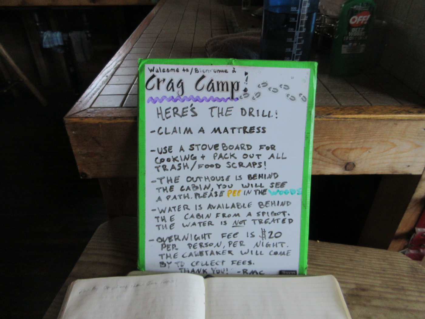
In another 0.1 mile the trail reaches the RMC's Crag Camp, seen here from the nearby Upper Crag.
King Ravine headwall from the Upper Crag.
Down-look to the lower floor of the ravine.
Welcome/bienvenue!
A cozy camp.
Room with a view.
Crag has a nice deck for sunning and admiring the view.
Ferny woods above Crag Camp.
The original objective for my hike was the Knight's Castle, a crag with a cool name and a great view from the rim of King Ravine.
This is one of the great perches on the Northern Presidentials.
Crag Camp below.
A wide view to the northeast.
Knight's Castle is a worthy destination in its own right. My original plan was to come here, hang for a while, then meander back down over a series of lower elevation trails. The spectacular day prompted a change in plans. Onward and upward to get above treeline!
This cairn marks the point where the Spur Trail breaks above treeline.
Looking across at Mt. Madison, Durand Ridge and John Quincy Adams. A fantastic day in the alpine zone.
Mount Adams in sight ahead.
The pyramid of Madison.
Many cairns mark the way.
Looking back towards Mt. Abigail Adams. In the distance are the Pliny, Pilot and Nash Stream Ranges.
The junction with Lowe's Path.
Thunderstorm Junction, just beyond.
Looking back from the Lowe's Path/Israel Ridge Path junction at Sam Adams and vast western horizons. With 120-mile visibility the pyramid of Mt. Whiteface and the broad bulk of Giant Mountain were dimly visible in the Adirondacks, peering over the long chain of the Green Mountains.
The second highest rockpile in the Northeast, as seen along Lowe's Path.
The sharp and rocky summit, adorned with just a couple of trail signs.
East to the Carter Range.
The most dramatic vistas from Adams are towards its massive Presidential ridgemates.
Mt. Jefferson and Jefferson Ravine.
Mt. Washington and the huge gouge of the Great Gulf.
The classic vista down to John Quincy Adams, Star Lake and Mt. Madison. Several Maine 4000-footers could be seen in the distance.
Summit pin, perhaps placed in the 1980s during the survey for Bradford Washburn's elegant map of the Presidential Range.
Hikers starting down the Air Line.
Looking back up the jumbled rocks on the Air Line. A daunting sight if you're ascending.
The receding summit of Adams.
Looking north down King Ravine, evening shadows creeping in.
Mount Madison at its sharpest.
The Gateway at the top of King Ravine, where the King Ravine Trail issues forth between crags.
Looking across the headwall.
Durand Ridge and its "Knife Edge," one of the finest alpine walks in the Whites.
Sheared-off crags.
Snyder Brook valley, V-shaped in contrast to the glacially-carved U-shape of King Ravine.
The views just keep coming.
Peering down through a mini-gateway.
The Chemin des Dames is the shortest of three wild steep and rocky trails that climb out of King Ravine.
Last view looking up the ridge, at 4360 ft.
A nice section of Air Line through the woods.
I prefer the longer route down the wild, mossy Scar Trail, which has mostly good footing, and then the lower half of the Valley Way trade route, versus the lower half of Air Line, which presents a tired hiker with a long steep and rough descent.
If you take the Scar Loop you get to visit the ledge outcrop known as Durand Scar.
This offers an unusual view to the peaks up the valley of Snyder Brook.
Last sun on John Quincy Adams and Mount Adams, from Durand Scar.
If all the soil wears off here, this could be a tricky sidehill traverse.
Descending Scar Loop.
The wide and well-trampled Valley Way.
With darkness closing in, I took the lovely Fallsway along Snyder Brook to see several waterfalls in the gloaming, and even made a lame attempt at a flash photo of Tama Fall, capping off a super day on Mount Adams.