This adventure on a cool, breezy partly sunny day took me 2.1 miles up the Ammonoosuc Ravine Trail to Gem Pool, to see how the 2017 Halloween Storm impacted the trail. From there I rock-hopped up the slide track/brookbed to the location in Ammonoosuc Ravine where three new slides, all from the Halloween Storm, converged into the bed of the North Branch of the Ammonoosuc River. It is a scene of impressive destruction.
Alongside the trail is this memorial to a Dartmouth student who perished from hypothermia near here in 1928, after his group was driven off Mt. Washington by gale force winds.
There are several recent washouts along the second mile of the trail as it follows the Ammonoosuc River. Three major events have impacted this area: a large avalanche in 2010, Tropical Storm Irene in 2011, and the Halloween Storm in 2017.
Tree carnage along the river.
Caution needed at this washout.
The riverbed was widened by the 2017 storm, and a few steps left of the trail is this open view up to the headwall of Ammonoosuc Ravine.
Three-log span over a deep washout.
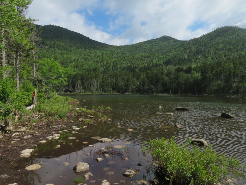
Gem Pool, where the steep climbing begins on Ammonoosuc Ravine Trail.
Here I left the trail and after a short bushwhack began following the jumbled rocky track of the 2017 slides into the north branch of the ravine.
Rocks of all shapes and sizes, some of them loose. Careful attention to footing required, making for slow going.
Note the gouging on the sidewall, evidence of the powerful force of the slide.
First little ledge scramble.
The headwall and the northern of the three slides in sight ahead.
First views back to the Twins.
I tried to imagine the force needed to move this monster rock.
I didn't like the slippery footholds for climbing up over this cascade, so I resorted to a heinous bushwhack through the dense scrub on the side, partly on hands and knees. On the way back down I took my pack off and was able to slither down over the lip of the cascade.
Looking back down where I emerged from the scrub.
Rocky chaos as I approach the convergence of the slides.
Devastation.
Convergence of the 2017 slides: the north one on the left, the western of the two southern slides on the right. The third slide is out of sight, around the corner. In the center is the rocky gully on the headwall of the ravine's north branch.
This is the biggest slide of the trio.
Scrambling up the lower part.
A wild scene of slab and wall.
Close up.
Yikes! One of the more savage-looking slides I've visited. Time to turn around.
Looking down.
Profile of the northern slide.
Nice vista of the Bond-Twin Range with Mt. Tom and the Rosebrook Range in front.
I dropped back down to the base and scrambled a short distance up the headwall gully to the eastern of the two southern slides.
Mountain Avens blooming on the ledges.
Another steep and rugged slide. The two southern slides share an apex, but are distinctly different slides below.
Cascades coming down from the headwall gully.
I scrambled up to a perch with an impressive angle on the slide.
Time for an extended break in the partial sun.
Labrador Tea was blooming next to my spot.
Bunchberry, too.
After a snooze I scrambled partway up the right edge of this slide.
I edged out onto this nice shelf...
...for a close look at a colony of Mountain Avens clinging to the steep ledges.
I descended back to the convergence, where revegetation is well underway less than four years after the storm.
Tree graveyard.
Next I worked a little ways up on the northern slide. Quite a wild, rough playground in here.
From here I had a peek up at Mt. Monroe.
Looking down from the northern slide.
Side view.
Looking across at the southern slides.
On the descent I stayed on the slide track the whole way, skirting around this pretty cascade and pool.
Lower down, there was a fine panorama up to the Ammonoosuc Ravine headwall, with the north branch on the left, where I spent the afternoon at the slides, and the Central Gully on the right.
Zoom on a lofty cascade at the base of the Central Gully. Lots to see out here in Ammonoosuc Ravine.