
MT. FIELD & MT. WILLEY: 8/27/13
Decided to revisit a couple of old favorites in the Willey Range on a hot, humid and hazy day in which the views improved later in the afternoon. When I pulled into the parking area by the old Crawford Depot (now the AMC Macomber Family Information Center), by chance I ran into Mark "Silverfox" Tuckerman and his nephew, Ben. It was a pleasure to hike partway in with Mark, who is very close to finishing his "48 X 12" grid (next spring), and Ben, who is working on his first round of 4000-footers. Field, Willey and Tom would be #29, #30 and #31 for Ben. The photo below was taken at the start of a recently cut relocation about 0.6 mi. in on the Avalon Trail.

At the A-Z Trail junction I stopped for a sit-down break, while Mark and Ben - faster hikers than me - continued up the Avalon Trail.

The next section of the Avalon Trail, leading up to Mt. Avalon, has some steep, rocky climbing. Because of the humidity, the rocks were glistening with moisture and quite slippery.

The side trail up to the summit of Avalon has several ledge scrambles. This one is a bit harder than it looks and has an alternate workaround path.

The rocky summit of Avalon is one of the better viewpoints on the Willey Range, though not quite as open as it used to be. Mt. Willey (L) and Mt. Field (R) can be seen in the background.

Avalon has a fine view south down Crawford Notch, though rather foggy/hazy on this morning.

A bird's eye view of the Highland Center and Saco Lake.

A ledge on the back side of the summit has a clear view up to Willey and Field.

The climb from Avalon to Field is fairly steep in places, with quite a few ledge slabs in the footway.

Sign at top of the Avalon Trail. It's a short jaunt to the summit of Mt. Field from here.

Just before the summit of Field there's a decent standing view to the west, including this look at the Twins. It seemed a bit more open than the last time I was up here a few years ago.

A hazy look at Mt. Bond (L) and Mt. Guyot (R). While I was taking a break at this spot, which has a convenient tree trunk seat, a Gray Jay came by. It was soon scared off, squawking, by a marauding Sharp-shinned Hawk.

The northeastern viewpoint at the summit of Field has been "enhanced" by the cutting of some scrubby trees. The view here includes Mt. Tom (L) and Cherry Mountain (R).

The vista towards Bretton Woods and Mt. Deception.

The Mount Washington Hotel, "Grande Dame of the White Mountains," and a place of employment for me in the 1970s and 1980s. Lots of good memories there.

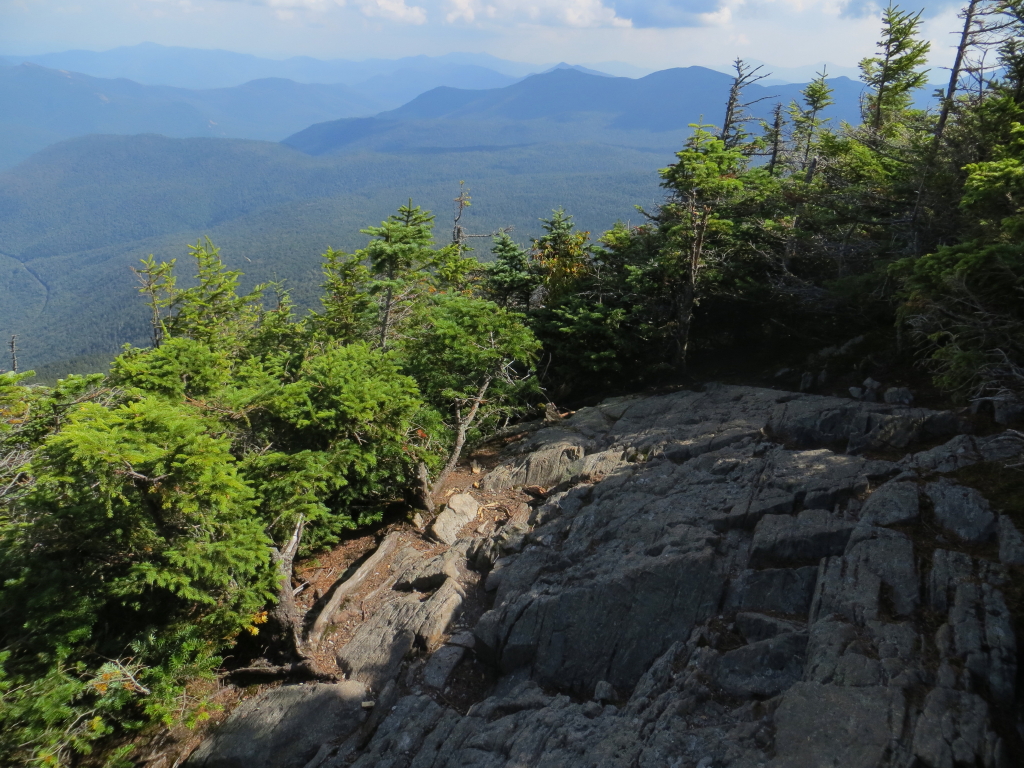
There's an interesting and unusual view into the eastern Pemi Wilderness from a scrubby sidehill stretch on the Willey Range Trail, about 0.2 mi. south of Mt. Field. Near here I saw Mark and Ben again, on their way back from Mt. Willey.

The cone of Mt. Willey in sight ahead.

Farther along the ridge is an area that was devastated by Hurricane Sandy in the fall of 2012. Kudos to those who cleared the blowdowns from this stretch of trail - amazing work!

A mossy Tolkien forest along one of the meandering sections of the Willey Range Trail.

Vista of the eastern Pemi from the western outlook on Mt. Willey.

A smoky Mt. Carrigain.

The Twin-Bond Range from the western outlook.

Cairn at the summit of Mt. Willey.

The eastern outlook on Mt. Willey. Nice spot to hang out for a while. Nancy Range in the distance.
The Webster Cliffs.

Looking down into lower Crawford Notch and beyond to the lower peaks of Montalban Ridge. Few summits give such a sense of loftiness as Mt. Willey.

The Presidentials finally emerged from the clouds.

I went back over to the west side of the summit and bushwhacked down through dense growth to one of the talus patches that dot the upper west slope of Willey. I first visited these back in the winter of 1991 when a group of us bushwhacked to Willey from Ethan Pond, following the western spur of the mountain.

Looking down at the ridge we followed on that bushwhack. We tried to get out atop the cliffs, but they were well-guarded and not very accessible.

The talus offers a sweeping view over the eastern Pemi, with Ethan Pond below.

Ethan Pond, discovered in 1829 by the legendary pioneer and woodsman Ethan Allen Crawford.

For an hour, I was King of the Pemi.

Mt. Field, displaying its ragged western cliffs.

Parting shot from the talus.

Nice woods along the Willey Range Trail on the way back to Field.

Late afternoon vista from Willey Range Trail.

Cairn at the summit of Mt. Field.

Presys from the NE viewpoint on Field. It really cleared out nicely by the evening.

I made a loop descent by following the Willey Range Trail north from Mt. Field to the A-Z Trail. This is a very nice stretch of trail with pleasant grades and mostly good footing.

Mossy fir forest - a trademark of the Willey Range ridgeline.


