Friday, February 19, 2016


EAST OSCEOLA VIEW LEDGE: 2/18/16

A sunny, crisp day beckoned for a return visit to a ledge on the north ridge of East Osceola with a unique view into Mad River Notch. Though many trails are at present icy and unappealing, the snow conditions (in areas where there is enough snowpack) are great for snowshoe bushwhacking.  I first visited this ledge in March 2013 with master bushwhacker J.R. Stockwell, en route to a mostly off-trail ascent of East Osceola.

Starting off the Greeley Ponds X-C Trail a short distance in from the Kancamagus Highway, I bushwhacked SW through brushy hardwood forest up to the long, gentle ridge that runs NW from the cliffs that overlook Mad River Notch and the Greeley Ponds.


JR and I passed this boulder-hugging tree on our 2013 trip, and I went right by it again this time. What are the odds?


The ridge bushwhack was not super-thick, but was generally scrappy with many, many branches to push through. At times, safety glasses were handy.

There were occasional open stretches, too.


A big spruce towering among the smaller trees.


A twisted birch.


There was a nice corridor here, which reminded me that in the 1980s the WMNF proposed relocating the Mount Osceola Trail along this ridge. But ultimately the relocation was made under the cliffs on the south side of the ridge.


This was the deepest snow of the day, almost a foot!


The upper part of the ridge was pretty steep and scratchy.


The final approach to the ledges, after wandering around a confusing flat area for a bit.


Found them!


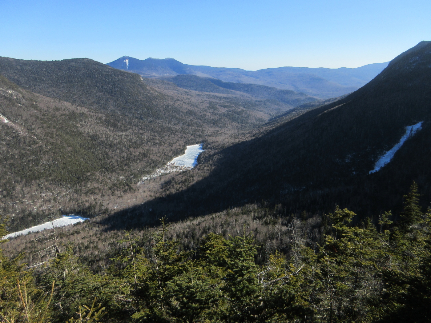
This is the Mt. Willard of Mad River Notch, looking down the glacier-carved valley past the Greeley Ponds. When we first saw this three years ago, it immediately became one of my favorite off-trail vistas.


Lower Greeley Pond, with Mount Tripyramid, a long arm of East Sleeper, and the northern Flat Mountain beyond. Flume Peak is seen under and just right of South Tripyramid.


Tripyramid, with some sun on the North Slide. Part of the "K1 Cliff" is seen in the foreground. (K stands for Kancamagus.)


Around the corner to East Huntington and Mount Tremont.


Time passed quickly sitting in the sun on this south-facing perch.


East Osceola loomed close by to the SW, under the low winter sun.


An icy slide on the steep flank of East Osceola.


The west knob of Mount Kancamagus, displaying the "K2 Cliff." The Goodriches of Waterville Valley roughed out a trail to this cliff a century ago. The terrain looks nearly impossible. A 1915 map by Arthur L. Goodrich shows that the trail came up the ridge descending to  the right. There was also a crude path to the K1 Cliff. Both were short-lived.


Shadows creeping into the Notch. After two hours lounging in the sun (in February!), time to head down.


On the way down, I caught this glimpse of Franconia Ridge and Owl's Head through the trees. 


A mini birch glade.


Late day sun on Mount Huntington.


The Osceolas from the best viewpoint on the Kancamagus Highway. The ridge I ascended to the ledges runs across the middle of the photo.


Thursday, February 18, 2016

GOODRICH ROCK AREA: 2/17/16

On a warmish partly sunny day following a strange weather day of 4" wet snow, then 2" of warm rain, I spent an interesting afternoon exploring in the "land of the boulders" on the flank of Mt. Osceola.The parking lot for the Livermore Trail was a skating rink, and the first part of the trail was icy in places and closed to skiing. Greeley Ponds Trail was mostly hard-packed snow.

By the Goodrich Rock Trail junction there's a good view of the Mad River, still iced-over after the heavy warm rain. I wouldn't trust that ice!


The Goodrich Rock Trail is a redliner's delight - lots of interesting stuff to see.


Partly buried rock steps on the initial stiff climb.


Lots of fine hardwood forest on the lower half of the trail.


The first of many interesting boulders.


The trail goes through this crack.


I had no problem getting through with snowshoes and a bulky pack.


Looking back through from around the corner.

This assemblage of huge rocks is known as the Davis Boulders. They were named for J.W. Davis, a summer resident of Waterville Valley who built the first trail here in the late 1890s.

A cool overhang.


Another passage between boulders.


Greenery in February.


A portal view into the forest.


This crevice is an optional route. A great trail for kids!

From the Davis Boulders I bushwhacked east and then north up through open hardwoods, in search of a potential view rock spotted on Google Earth and in a couple of photos taken from viewpoints to the east. 


Here there is a hint of the Tripyramids beyond gnarled old trees.

Tall yellow birches.


Woodpecker work.


A peek at North Tripyramid and its slide.


A magnificent maple.


Leaving the bright open hardwoods, I climbed through darker woods and rougher terrain, seeking my objective rock.


I found the possible view rock - a huge steep-sided boulder 150 ft. in elevation above Goodrich Rock. But I was unable to work out a way up onto the top of the rock to see a view.


Side wall of the rock.


With deep snow it might have been possible to get up on the rock from the back end, but not this winter.


From there I bushwhacked down through some scrappy terrain to Goodrich Rock. From this vantage I could see that the slope of rock above the top of the ladder was glare ice.


This is one of New Hampshire's largest glacial erratics, discovered in the late 1800s by Arthur L. Goodrich.


The ladder from below.


Goodrich Rock is on the "Terrifying 25" hiking list, and today it was more terrifying than usual. I switched snowshoes for spikes and climbed to the top of the ladder where this view awaited. No way I was going to attempt that without crampons, especially coming down to the top of the ladder.


Heading down from the rock on an icy stretch of trail, I caught this glimpse of Sandwich Dome and Jennings Peak.


An old-style WVAIA sign. There are very few of these left on the trails.


A natural table at the base of Goodrich Rock.


This giant rock, I call the "ocean liner." Rock climbers have dubbed it the "Old Old Wooden Ship."


A peaceful evening in the hardwoods.