A perfect early summer day for a loop over Mount Chocorua that includes
Carter Ledge, the Three Sisters and the main summit. This is one of the
best full-day loop hikes in the Whites with lots of open ledges, some
good scrambling, and ever-changing vistas. The route follows the Piper,
Nickerson Ledge, Carter Ledge, Middle Sister, Champney Falls, Piper,
Liberty, Hammond, Weetamoo and Piper Trails. 9.6 miles, 3200-ft.
elevation gain. Warning: long post!
Signs marking the first two links of the route.
The first view (a humble one) is from Nickerson Ledge at 1.4 miles, looking at Bald Mountain and the Ossipees.
The Nickerson Ledge Trail runs along a gentle spruce-wooded ridge that feels much higher than 1700 ft.
On to the next link.
The
Carter Ledge Trail is steep as it climbs to Carter Ledge. Partway up it
crosses the edge of a gravelly slide with one of many views up to
Chocorua.
Up onto the granite slabs.
Like
Welch Mountain, Carter Ledge is home to a colony of Jack Pine, a
fire-dependent tree found in only a few locations in the Whites.
Expansive ledges make this like an eastern version of Welch-Dickey.
An impressive view up to Chocorua and the Sisters.
The iconic peak.
The SE ridge of Chocorua - the route of the Hammond Trail - seen across the Chocorua River valley.
Long view to the south.
The open summit of Carter Ledge (2420 ft.). This is a good objective for a hike by itself.
Looking at Chocorua's wild, trailless NE spurs with Mt. Washington and the Moats beyond.
Beyond a col, the Carter Ledge Trail climbs steeply through dense spruces. Halfway up, it crosses this fine view ledge.
Narrow and brushy.
Approaching the "Terrifying 25" ledge, which requires several "interesting" moves to negotiate.
Going across the ledge, with a good dropoff on the left.
Looking down.
The
most exposed part of the scramble. The rock is good and grippy when
dry. Wouldn't want to try it when wet, nor anytime coming down.
Another great viewpoint above the scramble ledge.
Looking down a series of short scrambles just below the Middle Sister Trail junction.
Weathered signs.
One of several views while ascending Third Sister.
More fun scrambles.
Interesting angle, slightly off-trail on Third Sister.
Looking straight down into the Chocorua River valley.
Foundation
of the old fire lookout station on Middle Sister, built by the USFS in
1927. The original plan was to build it on the summit of Chocorua, but
strong public opposition led by the Chocorua Mountain Club, AMC and
SPNHF forced a change in plans.The station was designed by noted Boston
architect C. Howard Walker. It was abandoned in 1948.
Sweeping northern views from Middle Sister.
Looking ahead to First Sister and Chocorua.
The classic western view along the twisting Sandwich Range.
After a long break, on to more great views from First Sister.
If you don't like summit crowds, go to First Sister. There was nobody around while I was here.
The horn of Chocorua.
I
knew the summit would be a busy place for much of the day, as there was
a large summer camp group gathering in the Piper Trail lot when I
started. Thus I made a very leisurely loop, planning to reach the summit
in late afternoon.
Approaching the summit on the Piper Trail.
Looking down at Carter Ledge.
Peering back to the Sisters.
Perhaps my favorite Chocorua view - looking down the remote western valley followed by the Bee Line Trail.
Summit ahead.
Trail junction right below the summit.
The final gully scramble to the top.
Summit
benchmark and old survey pin. The faint etched triangle around the
benchmark and the bent pin date back to the U.S. Coastal Survey in the
1870s. From 1911-1926 there was a fire lookout station here, but it
consisted only of a table on a post to hold the observer's map and
sighting device.
North
view from the summit rock. There were only 4 other hikers at the top
when I arrived. The panorama from Chocorua includes the summits of 33 NH
4000-footers, and 32 summits on the NH 52 With a View List.
Cow Rock just out on the east side. Some legends hold that Chief Chocorua defiantly jumped to his doom from this lofty perch.
Just off the summit, a great spot to hang out and gaze westward.
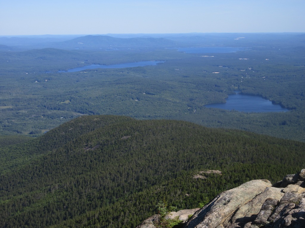
Southward view to the eastern Lakes Region.
The blue waters of Chocorua Lake, Silver Lake and Ossipee Lake.
Profile of the ridge followed by the Carter Ledge Trail from Carter Ledge to the Sisters.
A deserted summit at 4:30 pm.
More open ledges heading down the Liberty Trail.
Looking back at the summit.
Major junction of the Liberty and Brook Trails.
Another
viewpoint along the Liberty Trail, on the steep south side of the cone,
peering into the valley of Claybank Brook. The Brook Trail comes up
through this valley.
Steep slabs along the Liberty Trail. Trust your boots.
Jim
Liberty Cabin, built in 1924 and rebuilt in 1934 on the site of the
former Peak House. The Peak House was blown off the ledges by a
windstorm in 1915. Since then there has been significant tree growth at
the site.
View back to the summit from a ledge just above the Liberty Trail.
Ridgetop glacial erratics on the Hammond Trail.
Last view of the day, looking across at the morning's ascent route from ledges beside the Hammond Trail.
The link descending into the valley.
A peek at towering Weetamoo Rock.
Open hemlock forest along the Weetamoo Trail. The soft footing was appreciated after miles of rocky terrain.
GPS track for the loop.
Track along the ledgy upper ridges.