
MORIAH BROOK VALLEY: 9/25/14
The sprawling basin of Moriah Brook - seen in the photo below from a ledge on the east side of the Wild River valley - is one of the most hauntingly beautiful places in the Wild River Wilderness.
Moriah Brook flows down from the Moriah-Imp col through a valley five miles long, enclosed by the long eastern ridge of Middle Carter on the south and the lumpy, ledgy southeastern ridge of Mt. Moriah on the north. The brook is home to a wonderful assemblage of cascades and pools, some of which are visited by the Moriah Brook Trail. The valley floor and slopes are largely cloaked in hardwood and birch. The upper part of the Moriah ridge was burned in an 1895 fire and features numerous open ledges that make rewarding destinations for off-trail journeys.
On this fine partly sunny day, I headed over to Wild River for a visit to two favorite clifftop vantage points on a spur ridge off Mt. Moriah. I hoped to see some early fall colors both along the brook and in the vistas over the valley from the ledgy perches. I was not disappointed. I hope you enjoy this rather lengthy account of the day's adventure.

On the way to my starting point at the end of the gravel Wild River Road, I stopped to check out the new bridge built by the Forest Service at the north end of the Highwater Trail. It replaces a suspension bridge swept away by the high waters of Tropical Storm Irene in 2011.

The bridge has a nice view south down the Wild River, with colors popping out along the banks.

After admiring this view, I went a short way up the Highwater Trail to grab a geocache.

I started my hike from the Wild River Campground around 9:15 am. After a half-mile stroll along the Wild River Trail I reached the junction with the Moriah Brook Trail by this washout caused by Irene.

The valleys on the east side of the Carter-Moriah Range are long.

Suspension bridge over the Wild River at the start of the Moriah Brook Trail.

Another good view of the river.

Established in 2006, this is the newest Wilderness area in the Whites.

A section of the Wild River Trail along a washed-out riverbank.

Heading away from the Wild River up the side valley of Moriah Brook, the Moriah Brook Trail follows the grade of a spur line of the Wild River Logging Railroad (1893-1904).

The trail makes its first crossing of Moriah Brook at the head of Moriah Gorge.

Looking downstream into the mysterious gorge, the heart of which is quite difficult to access.

In the next section the trail offered some colorful vignettes of the brook.

In an area of beaver activity, Moriah Brook trekkers must follow the trail across a new beaver dam.

Water backed up behind the freshly-built dam.

A shoaly meander of Moriah Brook, with a hint of a distant ridge in the background.

I made a short off-trail foray to visit a series of beaver meadows and abandoned ponds on the south side of the trail.

A peaceful spot, silent save for the soft buzzing of resident insects.

This pond was water-filled on my last visit here in 2012.

Easy strolling along a birch-lined stretch of railroad grade.

Ledges and pools at the trail's second crossing of Moriah Brook.

Upstream view.

Farther along is this gorgeous cascade and pool combo.

An iron pin left over from a bridge or trestle during the early logging days.

The cascades keep coming along this delightful trail.

Wild spruce woods.

Deep in the valley, about 4 1/4 miles from the trailhead, I headed off-trail towards the first of the cliffs. At the start of the bushwhack I passed through this open, Catskill-like hardwood glade.

A sampling of the lovely birch forest found in much of the upper Moriah Brook valley.

A spruce-wooded plateau at the base of the first cliffs.

One of several moose beds I saw on the bushwhack. I was glad I did not encounter one, it being rutting season.

A moose-haunted fern glade.

Climbing steeply through the ferns.

Neck-deep in bracken.

After a struggle up through some rough terrain, the first ledge appears ahead.
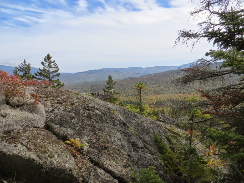
A marvelous perch overlooking the valley.

Colors were starting to pop down below.


A closer look at the bowl, perhaps a partly-formed glacial cirque.

Cliffs and foliage.


Just above, the second ledge offered a wide view down the valley....

...and a neat perspective up to the high ledgy SE knobs of Mt. Moriah. The peak on the right, in particular, is one of the great remote spots in the Whites. Click here for a fine report on a bushwhack to this peak by Chris "NeoAkela" Whiton.

A closer look at that rocky peak.

The ledge in this photo is split by a remarkable long, narrow crevice that shows up very well on the latest Google Earth image - almost like a junior version of the famous Trap Dike on Mt. Colden in the Adirondacks.

Looming ahead was my next destination, the "white ledge." It looked close, but, partly due to a poor route choice, it took me nearly an hour to reach it.

Spruce woods along the connecting ridge.

Looking down a thick and ridiculously steep pitch I hauled myself up, forgetting about an easier route I had used on two previous visits in the 1990s.

Looking up at the face of the ledge from a birch glade below.

Another moose bed.

This open draw was a moose highway.

Climbing steeply, circling around to access the clifftop ledge.

Emerging on the white ledge mid-afternoon. What a perch! I first visited this remarkable spot on a chilly spring day in 1996 with Creston Ruiter and Peter Doucette.

Mt. Hight, Middle Carter, Mt. Lethe, North Carter and a ridge of Imp Mountain.

An Irene-triggered slide under Mt. Lethe. Should this be called the "Bugs Bunny Slide"?

A look down at a birch glade I passed through on the ascent.

On top of the world.

A backlit view south towards Mt. Hight.

Mt. Hight and its lofty eastern ridge.

Late afternoon light on the Moriah Brook valley. It's 4:30, time to find a way down the steep slope and head for home sweet home.

Rest stop at cascade and pool before the final 3.2 mile walk out, done by headlamp below Moriah Gorge. A memorable fall day in the Moriah Brook valley!
