
ACADIA - DORR & CADILLAC MOUNTAINS: 4/21/11
On a day predicted to be partly sunny and very windy, I planned a hike that would take in a great variety of Acadia scenery. I was not disappointed.
I started the hike late morning at the trailhead on Route 3 for the Ladder Trail up Dorr Mountain, just south of a pond known as The Tarn. I planned to ascend Dorr, but by a longer, easier and more varied route.

In a short distance I turned L on the Kane Path, which runs at easy grades down a valley to the west of Route 3, with many beaver wetlands. Much of this first mile was through bright, open hardwood forest.
 There was a peaceful beaver pond at the junction with the Canon Brook Trail, featuring a view of Huguenot Head across the water.
I strolled out onto the walkway the Canon Brook Trail follows along a beaver dam.
 The other side of the pond provided a view up to the cliffs of Dorr Mountain. I then continued south down the valley on the Canon Brook Trail, passing more beaver ponds and listening to the daytime hootings of a Barred Owl.
A mile from the trailhead the route swung west for a short climb to the junction with the Dorr South Ridge Trail. Before heading up the mountain, I wanted to see some cascades farther west on the Canon Brook Trail. I soon reached this idyllic streamside spot by the junction with the A. Murray Young Path.
 Then the Canon Brook Trail climbed steeply up a rocky hardwood ravine.
Looking down a steep stack of rock steps.
 The trail ducked in and out of the brookbed, requiring some care to stay on course.
 After a 350-ft. climb the trail edged along the rim of a nifty flume. According to local lore, this was originally the Canyon Brook Trail, but somewhere along the way a mapmaker's error dropped the "y." Here, then, was the canyon.
 At the head of the flume was a beautiful cascade. This spot alone was well worth the hike. But as the late-night TV ads tease, wait - there's more!
Above the flume the trail climbed steep, open slabs of granite which were, thankfully, mostly dry.
 At the top of the ledge was one of the finest spots I've seen so far in Acadia, a comfortable lounging perch with a view across the valley to Champlain Mountain....
 ...and the brook sliding down beside you.
 After enjoying some sun here, I descended back to the Dorr South Ridge Trail.
 Right from the start, this was a delightful, easy to moderate climb up granite slabs through stands of pitch pine, a tree I associate with the sandy soils of Cape Cod, but which can also thrive on these barren ledgy slopes.
 Partway up, I could look across the valley to the cascade and slab I had just visited.
 One of the few steeper pitches on the Dorr South Ridge Trail.
 There were many views south to the ocean; in the foreground is a beaver pond nestled at the base of the ridge.
 At times the trail emerged on wide expanses of ledge, here looking east to Champlain Mountain.
 Not far below the summit, perches beside the trail provided an excellent close-up of the steep, rocky face of Cadillac Mountain. The wind was cold and fierce here, forcing me to don fleece hat, gloves and multiple layers.
 A visitor stopped by briefly on the next ledge over.
Looking out toward Frenchman Bay.
 A sign and large rock pile marked the windblown summit of Dorr (1270 ft.).
 The water around the Porcupine Islands was a beautiful shade of blue.
It was fairly late in the afternoon, but I wanted to explore the wild, cliff-faced gorge between Cadillac and Dorr, and, if time and trail conditions allowed, make a side trip to the summit of Cadillac and then descend the remote valley between the two mountains on the A. Murray Young Path. From the summit of Dorr I continued a short way north to a multiple trail junction.
 The trail down into the notch dropped steeply, as expected.
 There were some great close-up looks into the notch (or gorge as it's called locally), with impressive ragged cliffs on the Cadillac side.
 Just another scramble on an Acadia trail.
 From the floor of the notch, I could look up at cliffs and talus on the Dorr side.
 A forested corridor led to a four-way junction.
 The start of the climb on the Cadillac side. Rugged country out here.
Soon I was looking across at the west face of Dorr.
 View south down the notch, with the ocean on the horizon. There were many great ledge perches along this climb; unfortunately there was no time to linger this late in the day.
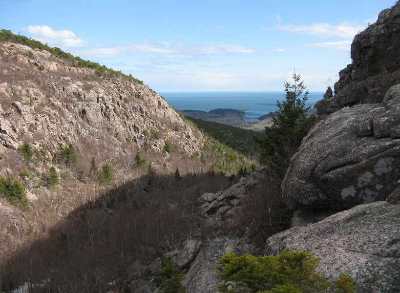 Looking down to the floor of the notch.
 Once above the wall of the notch, the climb eased, with the Cadillac summit area in sight ahead.
A view down the valley I planned to descend.
 Though Cadillac is accessible by auto road, the summit area is only lightly developed - a parking area, a paved loop trail, one radio tower back near the partly-wooded true summit, and a gift shop building tucked into the trees.
 The "viewing summit" offers a great sweep over the ocean.
 There were some nice panorama panels here. I couldn't find any printed versions of the Cadillac view panorama at the stores we visited during our stay.
 The true summit is about 0.1 mi. SW of the view summit, along a gravel spur road that serves as the start of the Cadillac South Ridge Trail.
 Yup, here was the benchmark - the highest point on the U.S. eastern seaboard: 1528 ft. or 1530 ft., depending on which USGS map you prefer.
 It was almost 5:00 pm, time to head down. This was a neat shelf section of trail on the way back down to the notch.
 At the bottom I turned R on the A. Murray Young Path, which at first led through a rock-strewn birch corridor between the walls.
 Then it led through a jumble of talus, with a few patches of old, deep snow where I stepped very carefully to avoid postholing into crevices between the rocks. What a wild stretch of trail - Acadia's version of Mahoosuc Notch.
 There's talus everywhere at the bottom of the notch.
 Farther along there were views up to the cliffs on the Cadillac side.
 Then the trail mellowed out and began a pleasant descent down this quiet valley.
 Farther down, it followed a tumbling stream. In places the footway was paved with flat rocks.
 Brook scene in the lower part of the valley.
 Near the lower end of the trail was a plaque commemorating the man for whom it was named.
 From here, it was an easy 1.2 mi. walk back to the car, with a stop to admire the evening scene at the beaver pond. Come December, this will certainly be included in any list of "best hikes of the year."