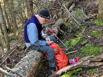
On a gorgeous cool, sunny late summer day, two old goats teamed up for a bushwhack ascent of Carter Dome, the highest peak in the Carter Range. Thom Davis and I - who have more than 140 years between us - have been talking about ascending the big NW slide of Carter Dome for a couple of years, and today was the day.
For various reasons, we didn't start up the Nineteen Mile Brook Trail until 10:00 am, a late start for a fairly ambitious bushwhack.
We left the trail some distance above the crossing of the tributary brook that drains the slide and headed up through the woods on the broad NW slope of Carter Dome.
For a short distance we ascended through beautiful open glades of hardwood and birch.
Then came the hobblebush.
We tussled with this for quite some time.
As we gained more elevation, the hobblebush began to fade away.
Then the woods became more open, though the slope was steep and the footing uncertain in places.
In one area well above 3000 ft. there were many deer prints punched into the turf.
Up and up we went, gaining a chunk of the 2300 ft. of off-trail elevation.
Early in the afternoon, at an elevation of 3500 ft., we took a lunch break on a convenient blowdown. Up to this point we felt like we were making pretty decent time.
As expected, the whacking became tougher from here on up to the slide.
The terrain was confusing up here, with several gullies and drainages indenting the slope. We crossed several of these, with some steep drops in and climbs back out.
We knew in which direction the bottom of the slide would be found, but did not know the best way to get there. (The slide has two forks; we were aiming for the bottom of the longer and more open eastern fork.) Thom dropped into a major gully with flowing water and followed it up, negotiating a steep and slippery route that soaked his boots. I ascended through the woods roughly parallel to the gully. This route looked pretty feasible at first.
But the woods quickly thickened to jail cell stature on a very steep slope, and the next several hundred feet of elevation involved some intensive effort of bulling, squeezing, pushing, pulling and cursing. Higher up I encountered some steep mossy ledges and boulders and had some anxious moments. Would I hit a dead end and have to go back down through this awful stuff, and find another way? In a few spots I had to crawl up, but I made it to a point where the grade eased a bit and I could catch a breather and regroup. Thom had been blowing his whistle occasionally, so I knew he was making parallel progress up the deep gully. From here an eastward traverse across the slope should bring me to the base of the eastern slide fork, which was confirmed when I heard Thom shout "I'm on the slide!" Welcome words indeed. When I looked at my GPS track later at home, I discovered that on the steep, thick climb I had been going up the totally overgrown lower track of the western fork of the slide.
It was mid-afternoon when I emerged from the woods and scrambled up into the open to rejoin Thom at ~3900 ft. Hard to say which of us had the best (or worst) route for the final climb to the base of the slide.
First view back to the Northern Presidentials.
Time for a much-needed break.
Then we began the 600 feet of climbing on the slide, a very steep one with a consistent grade of 36 degrees.
Partway up, a steep ledge wall loomed ahead.
Thom successfully made the scramble to the top of the ledge barrier. After rejecting a couple of possible routes as too sketchy, with a helpful pointer from Thom I ended up making the same moves as he did up and across a spicy pitch. Thom, an experienced climber, labeled it a "no fall" spot.
Looking down from above the ledge barrier.
The view expands to take in Mt. Washington on the left.
Onward and upward. A study of aerial photos suggests that this slide fell in the early 1960s, exact date unknown. It is mostly composed of soil and loose rocks of various sizes. It is partially revegetated, mostly with stunted spruce and firs.
Thom enjoys a light dinner.
The outlook on the NW side of the summit clearing is getting more restricted but still has a decent standing view.


Such a great view of the North Presys. Huntington Ravine looks daunting, Adams has a peak, the false summits of Madison on full display.
ReplyDelete