For the final hike in a spring series focusing on peaks along the Appalachian Trail south of Mount Moosilauke, Carol and I headed down to Hanover and Moose Mountain. The long ridge of Moose Mountain is a prominent Hanover landmark and is the first peak climbed by the northbound Appalachian
Trail after it enters New Hampshire. The AT, here known as the Moose Mountain Trail, runs over both South Moose
(2293 ft.) and North Moose (2313 ft.). This long ridge is one of my favorite hikes in spring, featuring miles of hardwood forest and abundant wildflowers, plus a couple of interesting views. Other hikes have more expansive views, but the trails on Moose are delightful to hike, a case of the journey being the destination.
We started late on a sunny, warm morning on the gentle North Cabin Trail, which provides access to the Dartmouth Class of '66 Lodge from Three Mile Road. Our plan was to find five geocaches along this half-mile walk. Then Carol would return to the car and head over to Vermont for geocaching across several towns, while I would traverse Moose Mountain and emerge at the northern trailhead on Goose Pond Road.
The first half of North Cabin Trail is wonderfully piney.
The caches we found had a birdhouse theme. It was a fun little series.
Carol heads out for her afternoon of Vermont geocaching.
The Dartmouth Outing Club's Class of'66 Lodge can accommodate up to 49 persons.
The door was unlocked, so I took a peek inside.
To ascend the South Peak of Moose Mountain, I followed the Nat Thompson Trail, which starts right behind the lodge. This trail was opened by the Dartmouth Outing Club in 2010. It was named in memory of a
son of Class of '66 Dartmouth grad Ted Thompson, and was opened with
assistance from the Thompson family.
After a stiff initial climb the trail joins an old woods road leading up an attractive brook valley cloaked in hardwoods. The first time I climbed this trail in late April 2011, there were long sections of wet footing. Today the trail was mostly bone dry, and the wet sections of the old road had footpath bypasses on the left.
Great spring hiking in the sunny bare hardwoods.
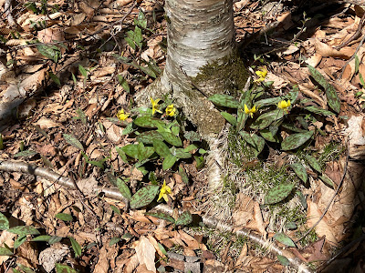
As I had hoped, there was a Trout Lily bonanza on the slopes of South Moose.
One of a number of fine rock waterbars built on this trail by DOC.
Trout lilies were everywhere...
...thousands of them!
A neat corridor leading up to the South Peak.
Trout Lilies and Spring Beauties sharing a root.
There is a spacious clearing near (but not quite at) the summit of South Moose. This was the site of a tragic airplane crash in 1968.
The summit was cleared as part of the rescue effort. The area is still
open today; it appears to be periodically re-cleared.
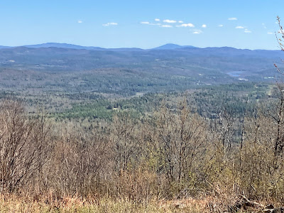
There's a nice view to the east and southeast.
Mount Cardigan and its satellite ridges sprawl beyond Goose Pond.
Ragged Mountain and Mount Kearsarge in the distance.
I made a short bushwhack to check out a lovely little ledge-meadow. There may have once been a good view to the northeast here.
The Moose Mountain Trail makes an easy-graded descent toward the col between South Moose and North Moose.
In the col the trail crosses the historic Old Wolfeboro Road. In 1772
Governor John Wentworth, the last of New Hampshire’s royal governors,
had this road built from his residence in Wolfeboro (near Lake
Winnipesaukee) to Hanover, passing through the Moose Mountain col. Some
sources say the road was built so that the governor could more easily
keep an eye on restive Connecticut River valley settlers in the
tumultuous days before the American Revolution. Another states that it
was made so that he could attend the first commencement at Dartmouth
College. Variously known as the Province Rd., Governor’s Rd. and
Wolfeboro Rd., it was at one time used as part of the Appalachian Trail. I found a geocache near the junction.
Gorgeous hardwood forest cloaks this col.
The Moose Mountain Shelter is located on a side loop path just north of the col. Having visited it several times, I kept to the main trail today.
Park-like forest.
I spotted a few Dutchman's Breeches as I headed along the ridge towards North Moose.
There are long stretches of narrow, easy-graded, leafy footway lined with hardwoods and spring wildflowers. Wonderful walking!
This sign is on the south knob of North Moose. The north knob is slightly higher.
This little ridgetop water body (Moose Mountain Pond?) resides next to the trail.
Just past the pond is an especially resplendent hardwood glade.
A band of quartzite ledges stripes the west side of the true summit of North Moose.
Here there are restricted views of Killington (R) and Shrewsbury (L) Peaks...
...along with Salt Ash Mountain (R) and Dorset Peak (just peering over on in back on the L).
A lovely mini-valley beside the trail along the northerly descent off North Moose.
Impressive rock work by the DOC.
The NE viewpoint partway down the upper mountain is not as open as it used to be, but it still provides an excellent view of massive Smarts Mountain, framed between Holts Ledge (L) and Winslow Ledge (R).
There's also a distant look at Mount Tecusmeh, Mount Tripyramid, the Sleepers, Stinson Mountain and Sandwich Dome.
Farther down is a section where the trail descends over neat quartzite ledges.
Red Trillium!
Reaching the trailhead on Goose Pond Road, where Carol was waiting after a successful geocaching jaunt.


No comments:
Post a Comment