
MOOSILAUKE SOUTH PEAK: 8/27/15
On a cool, cloudy day I enjoyed an interesting hike up the Moosilauke Carriage Road with Linda Moore, featuring visits to several historic sites and dramatic views on the South Peak with clouds racing by.
Just a short way in from the scenic trailhead at Breezy Point, we visited the site of Merrill's Mountain Home, a farmhouse converted to an inn that welcomed guests from about 1860 to 1915. The foundation of the main house can be seen to the left of the trail.

A moss-grown well near the foundation.

A twisted bedframe and a handle from ?

There were quite a few blowdowns approaching the lower Hurricane Trail junction. We took some of them out with our Silky saw. This is a before photo of a fresh, leafy blowdown.

Good work by the sharp Silky saw.

Just past the lower Hurricane Trail junction we crossed the Camp Misery Memorial Bridge over Big Brook, built by the Dartmouth Outing Club in the mid-1990s. We tried without success to pinpoint the location of the 1930s vintage Camp Misery shelter, which was just beyond the bridge on the left.

There were some fine patches of late summer wildflowers along the Carriage Road, including the trumpet-shaped orange blooms of jewelweed or "touch-me-not." We also saw turtlehead, lance-leaved goldenrod, pearly everlasting, and, on South Peak, a single bloom of mountain sandwort.

A gorgeous mature hardwood forest lines the middle section of the Carriage Road.

We thought that the water seep in this wet spot may have been the "Halfway Spring" referred to in 19th century descriptions of the Carriage Road. There were also several candidate water flows for the "Cold Spring" that was reportedly located along the road shortly before it reaches the crest of the ridge.

An inviting corridor at 2950 ft.

White-blooming asters were prolific in places beside the trail.

The first of several views looking back from the Carriage Road, with Mount Cushman in the foreground.

Not far off the trail are the collapsed remains of the Wadchu Shelter, built by the DOC in 1935 at the top of the notoriously steep ski trail known as Hell's Highway.

What may have been the uppermost part of Hell's Highway.

A DOC sign points the way to the South Peak of Moosilauke, our objective for the day.

Lovely mossy trail leading across a little col.

This plaque atop South Peak honors Pennington Haile, an alumnus whose funding enabled Dartmouth to purchase a majority of the 4500 acres it owns on the east side of Moosilauke. One tract was purchased in 1965, another in 1979.

We opted not to go across to the main summit, which remained mostly in cloud with a chilly wind.

Linda takes a photo of thru-hiker "Rainbow," who was very excited to be in the Whites.

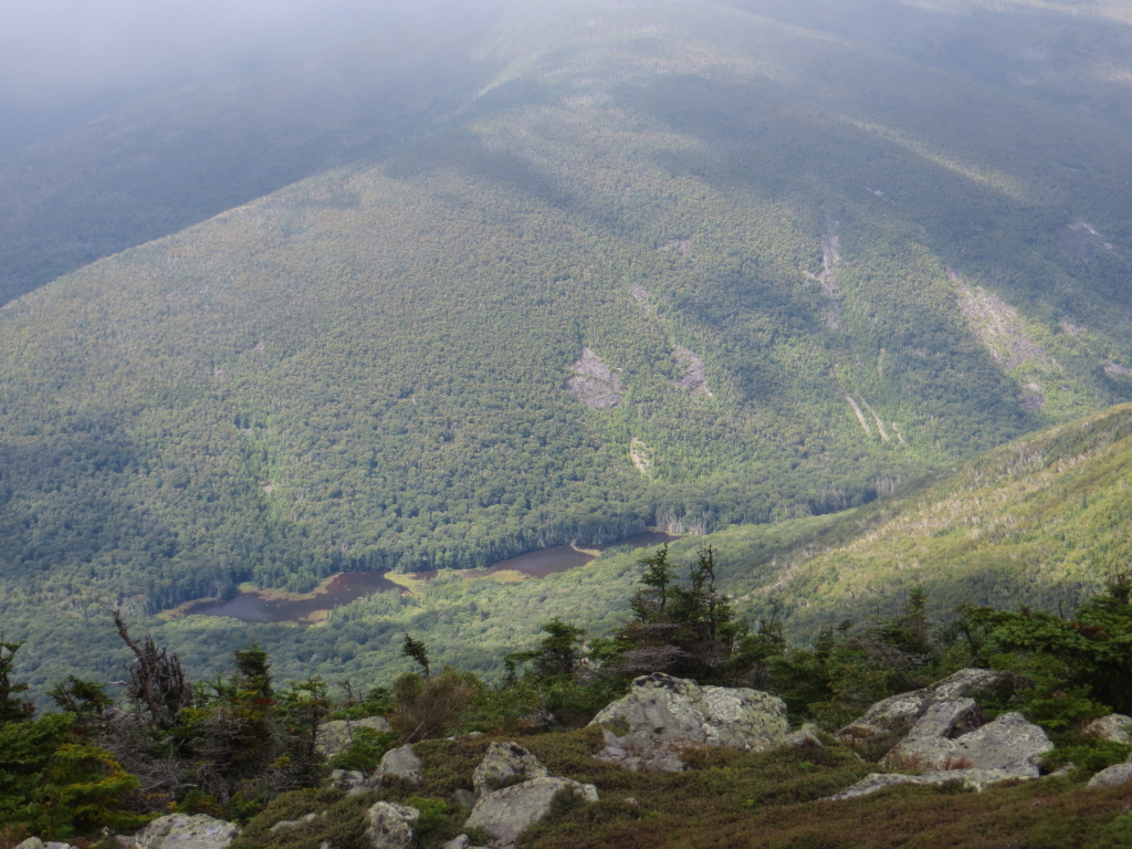
The classic view from South Peak peers down at Mud Pond and adjacent beaver ponds in Tunnel Brook Notch, with the slides of Mount Clough above.
The view to the east, which has been enhanced recently by a bit of scrub-trimming.

Clouds were racing over and sometimes across the peak, creating some interesting visuals.

Looking west to Mount Clough, Black Mountain in the Benton Range, and distant ridges in Vermont. When the cloud deck lifted just a bit, it was clear enough that we were able to spot Camel's Hump and other summits in the Green Mountains, as well as several far-off Adirondack high peaks such as Giant, Rocky Peak Ridge and Marcy.

The orange DOC signs at the Glencliff Trail junction are bright on a gray day. These replaced signs that were stolen last winter by unknown parties.

More good views on the way down the Carriage Road. We could see Mount Monadnock in the distance just to the right of Mount Cardigan.

Looking towards the Sandwich Range.

It's always enjoyable walking this historic trail.

The abandoned nest of a small songbird.

A beautiful corridor.

A scene along Big Brook above Camp Misery Bridge.

We went a short way up the Hurricane Trail to visit the site of Camp #1 of the early 1900s Park Lumber Company operation. Right by the junction we saw a bear, who peered at us for a second, then took off at a run. At the camp location we looked at several artifacts, including this head of a logging tool known as a peavey, with its point and hook missing.

The view of Big Brook from the camp location.

Evening view of Mount Kineo and Carr Mountain from Breezy Point.

South Peak, a worthy destination in its own right, looks far away from here. It's about a 9-mile round trip with 2850 ft. of elevation gain.

Thanks for the pictorial, thoughtful and pretty. I haven't been on the upper Carriage Rd above Snapper in over 10yrs and am amazed at how grown in the Carriage trail is from the 1st time I was on it in 1993. Hiked down the lower section of Carriage Rd from Snapper on 10/28 and it gradually gets wider and more grassy like days of old. Down at Camp Misery bridge, we couldn't find signs of the old camp around there either. Again, that's for the post!
ReplyDelete