
John "1HappyHiker" Compton, John Gutowski (one half of "J & J"), and I headed over to the wild country east of Evans Notch for a 10.3 mi. loop (with a surprising 2900 ft. of elevation gain) over Red Rock and Butters Mountains via the Miles Notch, Red Rock and Great Brook Trails. For both Johns, this would be new territory traversed, and would bring John G.'s reamaining White Mountain redlining mileage down to 183. For me, it would be a return to a favorite area in the Caribou-Speckled Wilderness, a trail check for the White Mountain Guide, and a chance to show friends the amazing spot atop the Red Rock Cliff. These trails are remote, wild, and lightly traveled. They are only intermittently marked with old blazes and small cairns , and following them can be a bit puzzling at times.
We rendezvoused at the Miles Notch/Great Brook trailhead (elevation 490 ft.) on Hut Rd. in Stoneham, Maine. The Miles Notch Trail sign was missing, but the trail starts up an old woods road across from a grassy parking area. Things were greening up at the lower elevations.
 The route starts with a 500-ft. climb up a ridge, leading into a red pine/oak/ledge area.
 We found some early saxifrage in bloom.
 Trailing arbutus was also flowering along the trail. John G. demonstrated the proper technique for sniffing these sweet-scented flowers.
 After cresting the ridge, you begin a rather disheartening 400-ft. descent into the valley of Beaver Brook, which drains south from Miles Notch.
 This was the first painted trillium I'd seen this spring.
 At the bottom of the descent we followed and then crossed a branch of Beaver Brook.
 Then we made a steady climb through hardwood forest up towards Miles Notch.
 This large oak was on the rim of a beautiful bowl of open hardwoods.
Farther up the valley we crossed Beaver Brook itself, here a tiny, rocky stream.
 This area was hit hard by the January, 1998 ice storm, with many large trees toppled. Many of these old blowdowns are still strewn beside and even across the trail, and the undergrowth is thriving under the open canopy. In April '98 I bushwhacked up the long south ridge of Miles Knob, visiting a number of ledgy viewpoints. Coming down the Miles Notch Trail, I descended into a maelstrom of fallen trees and limbs. It was a long struggle from the notch at 1850 ft. down to where the ice damage ended at 1000 ft., and for a while I thought I would be benighted.
 The trail approaches the upper notch along the eastern slope of the ravine, with a long line of cliffs looming across on the west side.
 Several openings give you clear looks up at the cliffs.
 What a wild and impressive place!
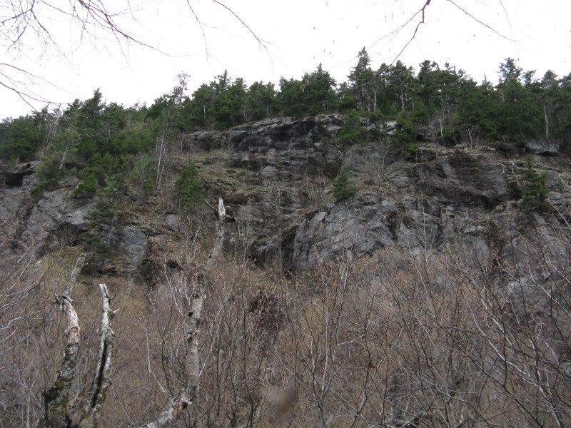 The floor of the notch is littered with talus. Geologists believe this narrow cut may have been carved by glacial meltwater. According to a Forest Service report, Miles Notch (along with Haystack Notch to the west) is home to an enriched hardwood forest community. We had hopes for some good wildflower sightings.
 As we neared the top of the notch, colonies of Dutchman's breeches appeared in the rocky area to the L. We took a break here for viewing and photographing these beautiful flowers, taking care not to trample any plants.
Some of the boulders on the floor of the notch sported cool fern gardens.
 This little wet spot is the source of Beaver Brook, with the actual height-of-land in the notch (1850 ft.) just beyond.
 Descending on the north side of the notch, there were colonies of bright green Indian poke in a wet area at the head of Miles Brook.
 We soon entered the Caribou-Speckled Wilderness.
 The forest changed from mature hardwoods on the south side of Miles Notch to a scruffy mix of birch and conifer on the north side.
 Near the junction with the Red Rock Trail we came upon the first of several old painted metal mileage signs. White Mountain historians Dave Govatski and Ben English note that these signs were commonly used by the USFS, especially in the eastern White Mountains, in the 1930s and possibly up through the 1950s.
 We turned onto the Red Rock Trail and descended to cross Miles Brook.
 After a 400-ft. climb we reached the ridgecrest on Miles Knob and headed westward through nice spruce forest.
 In some spots the trail was carpeted with moose nuggets.
 We even encountered a few random patches of snow, pretty late in the spring to see it at 2000 ft. John fashioned a mini-snowman, who wouldn't be lasting long now that the sun had emerged after a cloudy morning.
 A neat hardwood col between Miles Knob and Red Rock Mountain.
 We climbed to the east knob of Red Rock, and with a bit of searching found the obscure, little-travelled path that descends a short distance to one of the premier perches in all the White Mountains.
We were pretty amazed when we emerged in the bright spring sun onto this airy clifftop. Finding a comfortable seat, John C. takes in the vast view south to Kezar Lake and Pleasant Mountain.
 The cliff drops off a couple hundred feet to beautiful hardwood forest at the head of Red Rock Brook.
 Most striking, perhaps, is the side view of the main Red Rock Cliff. Here the origin of
the mountain's name becomes apparent.
 A long view down the Red Rock Brook valley.
The vista looking more to the SW.
 Not a bad lunch spot!
 Close by to the east is Miles Knob, with its own cliff face that is accessible only by bushwhacking.
 To the west, Speckled Mountain rises above Durgin Mountain; in the distance are Carter Dome, Hight, Washington and the Royces.
 A zoom on Carter Dome/Hight/Washington/West Royce.
 This photo, taken a few years ago from an off-trail ledge near the true summit of Red Rock, shows the location of our perch. Although it looks precarious from this angle, the ledges are very grippy and perfectly safe when dry. However, anyone queasy about heights should stay back from the edge!
 Saddled up after a wonderful hour and a half stay in the brilliant spring sun.
The true summit of Red Rock (2141 ft.) is open and ledgy.
 There are some pretty good views to the north, such as this look through Tyler Notch to Old Speck in the distance.
 Looking NE to Puzzle Mountain and distant peaks in the Weld, Maine region.
 John G. tags the summit.
 Descending towards the Red Rock-Butters col, we had nice views of Caribou Mountain.
 Looking up at the east knob of Butters.
 In the col we found one of the biggest snow patches of the day. It was very firm with no postholing.
 Another old Forest Service sign marked a tricky left-then-right turn in the col; a more obvious path leads north through the col, but soon dead-ends.
 Partway up the ascent to the east knob of Butters, John C. spotted this viewpoint just 20 yards L of the trail, looking back at the ledgy flank of Red Rock.
 A nice vista of Kezar Lake, too.
 The long, rolling ridge walk on Butters featured varied woods: some dense spruce, patches of hardwoods, and occasional grassy spots such as this.
 One of the nice hardwood sections.
 I wanted to show the two Johns a unique view from a ledgy patch on the north edge of Butters Mountain's flat, sprucey crest (near the 2246-ft. high point) that I had visited a couple of times over the years. Due to a slight map transcribing error on my part, we came out a little too far to the west and thrashed around for a while in thick spruces, passing this deep old snowdrift.
 Working our way back to the east, we eventually found the ledge and stopped for a break in the late afternoon sun.
 This spot opens one of my favorite views in this region, across the broad valley of the West Branch of the Pleasant River - a forest seldom-trodden - to the spreading hulk of Caribou Mountain.
 A bit farther east, seen in the center of the picture under Tyler Notch, is a remote beaver meadow that Keith D'Alessandro and I visited last November.
 Looking NW to the cliffs of Haystack Mountain above Haystack Notch, with the Pilot Range in the distance.
We whacked back to the trail, east of where we left it, which assured John G. of covering every step for his redlining. I paused to take this picture of a particularly nice glade of ridge hardwoods.
 After a couple more ups and downs, we approached the junction with the Great Brook Trail in an open, park-like hardwood glade.
 From here it would be 3.7 mi. back to the cars.
 This col is one of my favorite spots on the ridge.
 A little ways down we passed this interesting ledge formation. For quite a ways the trail was fairly steep with poor footing and little marking; in a few spots it was difficult to discern the footway.
 At the bottom of the long descent was another reward on this interesting loop - a series of cascades on Great Brook, located just off the trail.
John gets the shot.
 This was the highest of the cascades. A beautiful spot!
 It was not much farther to where the trail merges onto an old logging road for an easy 2+ mile runout. We passed by the stone wall marking the old Butters homestead from the mid-1800s (also featuring a cellar hole and slate tombstone) and strolled down the road, which became gravel for the last 0.8 mi. (This section is driveable in summer.) A chorus of spring peepers and wood thrushes serenaded us along the last stretch, and we made it out about 8:15, finishing a long and extremely rewarding day!
 Here is a Google Earth overview of the terrain we covered. Definitely a walk on the wild side!
Nice report Steve. I see you were able to use a fair number of the pictures you took that day. Good thing you cut the count down or it would take two days to look through all the pictures! Thanks for a very fun day with lots of great exploring!
ReplyDeleteDefinitely a repeat visit though next time with June.
John
Thanks, John - could be the longest post ever! 'Twas a fine day all around.
ReplyDeleteSteve
Very neat. Love the old signs. Didn't know about this area at all. So much to explore when you don't worry about only hiking mountains above 4K.
ReplyDeleteHi Chris,
ReplyDeleteThis is a great area - would go there more often if it wasn't so far. Two of the other fine trips are the loop over Caribou from Rt. 113 and the ascent of Speckled via Evergreen Link and Cold Brook Trail.
Steve
Great report and photos Steve. That looks like an awesome loop. I've ventured into the Caribou-Speckled Wilderness only once. I did a short traverse over Speckled and Blueberry mountains last year. I love the area. I'm going to try and do some sort of hike in there every year.
ReplyDeleteI really like this one.
Thanks for sharing,
Joe
Thanks, Joe. Caribou-Speckled is a uniquely appealing corner of the Whites. The Red Rock loop has lots of variety, and at 10.3/2900 gives you a pretty good workout. Hope you can get over there this year!
ReplyDeleteSteve
does the cliff/ledge below the summit of Red Rock mountain have any flat area? or in the woods directly behind it? large enough to pitch a small tent?
ReplyDeleteYou might be able a spot on the ridge up behind the cliff, or somewhere in that neighborhood.
Delete