
In my quest to "redline" the trails in the AMC White Mountain Guide, two of the three biggest gaps I had left were two-mile segments of the Mahoosuc Trail on either side of Mt. Success. With a great forecast of sunny, cool and breezy weather, Carol covered the store for me and Keith D'Alessandro signed on for this carspot trek off the Success Pond Road.
The original plan was to spot one car at Carlo Col Trail on Success Pond Road and then head over to Shelburne, drive partway up the Mill Brook Road, and ascend the Austin Brook Trail to the Mahoosuc Trail at Gentian Pond. But Keith, an avid bushwhacker who is adept at coming up with unusual routes, proposed an alternative plan with a much shorter carspot: ascend via Carlo Col Trail, then descend back to Success Pond Road from the hump just N of Gentian Pond. He and his girlfriend Julie had whacked to the clifftop ledges of North Bald Cap earlier this year, and from there and on Google Earth he noted that logging roads and clearcuts had been extended up almost to the Mahoosuc Trail/Appalachian Trail in the valley under the North Bald Cap cliffs. As luck would have it, this would work for my redlining purposes, since twenty years ago two friends and I had bushwhacked up Lary Flume, east of the Austin Brook Trail, and emerged on the Mahoosuc Trail to the N of the hump, and then gone down the trail to Gentian Pond. So I had already hiked that half-mile section. While the descent under North Bald Cap would lack in aesthetics, it would save alot of driving, and offer interesting closeup views of the cliffs.
The contrast between cutover areas on the lower slopes and wild scenery along the ridge has long been a theme in hiking the Mahoosucs from the west and south sides. Beauty and desolation, all in the same hike. That contrast has been heightened in recent years by the wholesale clearcutting of the TR Dillon Co., known in the industry as a "timber liquidator." You can see for yourself in the photos below.
We caravaned up the dusty, washboarded Success Pond Road out of Berlin and spotted Keith's truck a short way in on the main haul road that we would use at the end of our descent, shortly before the trailhead for the Success Trail. Then I drove us another 3 1/2 miles to the logging road that is the start of the Carlo Col Trail, marked by an AMC trail sign. There is space for a couple cars a short way up this road on the L, and another spot on the R, where we backed in. Parking on the main road is not recommended as there is not much room and the corridor is used by large logging trucks.

We started out a little after 9 am. Accompanying us on the hike was Keith's chocolate lab, Katahdin, a great hiking companion, very friendly and lovable.

The first 0.6 mile is on a solid logging road through an area that was cut over about five years ago. The sharp peak of Goose Eye Mountain can be seen ahead. Where the main road bears R and more steeply uphill, a short branch road diverges L and downhill. The trail follows the L road, an easy turn to miss. We shouted up to two guys just ahead of us who had kept on the main road, saving them some miserable extra walking.

After a brook crossing and a short stretch through a strip of woods, the Carlo Col Trail ascends for nearly a mile through a vast, brushy clearcut, certainly one of the least appealing stretches of trail we've been on. On a rainy day you would be soaked in seconds.

The trail opens up briefly on a skidder road.

In these areas you have to blaze wherever you can.
 An area of slash next to the trail.
 Back into the brush for a long stretch.
At 1.7 miles we abruptly entered uncut woods, crossed a brook, and ascended through a beautiful mid-elevation forest.
 A quarter mile below the ridgecrest we made a short side trip to check out the Carlo Col Shelter and Campsite. A fine place to spend a night. There was no one there at the moment, though a large group of youths we had passed on the way up had camped here the previous night, and later in the day we met plenty of folks planning to spend that night at Carlo Col.
This bear box was right behind the shelter.

On to the Mahoosuc Trail, where we turned R to head south, new trail mileage for us.
 Almost immediately we faced our toughest scramble of the day (and there are many such scrambles across the Mahoosucs).
Keith had to help Katahdin up through these jumbled boulders and broken ledges.
 At the top was an open ledge with a wide NW view. Visibility was excellent on this cool, crisp, windy day - a welcome break from the prevailing hot weather this summer.
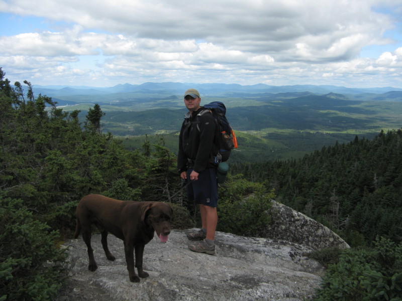
A mostly easy stretch along the wooded ridge brought us to the state line.
 A steep slab coming up from a col on the ridge.
 Fine trail work by the AMC trail crew is evident in many places along the Mahoosuc Trail.
 There's another boulder scramble coming out of the main col between Mt. Carlo and Mt. Success.
Some recent rock step work.

After passing the Success Trail junction, we had a glimpse of the summit of Mt. Success ahead.

There's a surprise short, steep down-scramble on the way up to Mt. Success.

Looking back up at the scramble.
 The final approach to the open summit, where Keith was chatting with a southbound AT thru-hiker, "Veggie."
"Veggie" heads across the alpine bog on the south side of the summit.

The summit ledge bears a triangle and bolt from the U.S. Coastal Survey dating back to 1878, and a newer U.S. Geological Survey benchmark.
 The top of Success is an excellent viewpoint, as evidenced by a panorama appearing in Scudder's White Mountain Viewing Guide. To the NE are the higher Mahoosuc peaks; L to R, Mahoosuc Arm, Old Speck, Goose Eye and Goose Eye, East Peak.
 To the N and NW are vast views into northern NH and NW Maine; Success Pond in the center.
 A great profile on the Pliny and Pilot Ranges to the W.
To the E, Bear Mtn. (R of center) and other intriguing peaks in the little-known eastern arm of the Mahoosucs. A bit of Sunday River Ski Area on the L end of the ridge.
 A north-bound thru-hiker, "Son-Dance," stopped by briefly. He is hiking to raise money for Alzheimer's research; see his blog at www.paultravers.com.
 It was chilly and windy on the summit, more like September than July. (No complaints!) After an hour of enjoying the panoramic views, we headed south across the bog on walkways placed recently by the AMC trail crew.
 Looking back at the summit knob.
After passing through a belt of woods, we emerged on the spacious south ledges of Mt. Success. What a great area!
 Looking out to the Carter-Moriah Range and the Presidentials.
 A close-up look at the ledgy Outlook on the flank of Mt. Success.
 To the SW along the Mahoosuc Range is the lower group of Bald Cap summits. Before entering the woods, we made one attempt at following a herd path down to the AT boundary swath to look for the wreckage from a 1954 plane crash. No luck - either we followed the wrong path or didn't go far enough along the boundary, and we didn't have enough time to keep looking for long.
Soon after entering the woods, we passed underneath this watchful male Spruce Grouse.
 We crossed a high plateau and came to the brink of a long, steep descent, where we caught a glimpse of North Bald Cap.
A couple of northbound guys we passed called this section "unrelenting" and another name that can't be repeated here. They were right - the trail drops 800 ft. in about 0.5 mi.
 After bottoming out, we climbed over two humps and then up to the top of a third, where Keith found this off-trail peek at the bog at the N end of Gentian Pond.
This hump was the departure point for our off-trail descent to Success Pond Road. We started with a very short bushwhack through open woods, where Keith found a moose antler. It was a little chewed up and stinky, not worth hauling out.

In a couple of minutes we were at the top of the clearcuts, with North Bald Cap ahead.
 As we headed down a faint, slash-strewn skid road, we had numerous views of the cliffs.
The Outlook of Mt. Success loomed on the other side of the valley.

 The western slopes of the Mahoosucs in 2010 - beauty and desolation. In a sense this is a throwback - many areas in the main part of the White Mountains were like this 100 years ago. Traveling through heavily logged areas was part and parcel of "tramping" in those days.
 After a long and at times tedious descent through the logged area, with careful foot placement required in the slash-filled spots, we ended up on the well-built main haul road, where we could look back at the ridges of Mt. Success. It was a long and interesting day, about 10 miles with 3000 ft. of elevation gain. The Mahoosucs are certainly unique among the hiking areas of the White Mountains.
"Beauty and Desolation in the Mahoosucs" is certainly an appropriate title!
ReplyDeleteI suppose that "Beauty and the Beast" might also work . . . the "beast" being the TR Dillon Company!
Beyond excellent report! Congratulations to you and Keith for a job well-done!
John
1HappyHiker
Sorry, but I just now (several days later!!) remembered that I also meant to comment on a something else you said in your report. I'm referring to the quote below:
ReplyDelete"In a sense this is a throwback - many areas in the main part of the White Mountains were like this 100 years ago. Traveling through heavily logged areas was part and parcel of "tramping" in those days."
My comment, although not that profound, is simply that I had never thought about this until now. How lucky we are in today's world where conditions such as you described are more the exception than the rule!
John
1HappyHiker
Your blog as really opened my eyes to so many different trails and areas in NH. Thanks for all these great posts. I really had never even heard of the Mahoosucs.
ReplyDelete