
On another of the many fine, partly sunny days we've had this August, Carol and I decided to head north to one of our favorite destinations: Rogers Ledge, a 2965-ft. peak at the northern end of the Kilkenny. This small mountain features a great south-facing cliff that offers wide views over the nearby backcountry and out to several distant ranges. It's reached by a moderate 8+ mile round trip hike from either the York Pond Road and Berlin Fish Hatchery to the SE or from the WMNF South Pond Recreation Area to the north. We chose the northern approach for this trek.
Here is a view of Rogers Ledge taken from The Horn.
 We arrived at South Pond, accessed by a side road off Rt. 110, just after the gate opened at 10 am. If you start before 10 am there is a 1.1 mi. road walk from the gate to South Pond. During the summer the gate remains open til 8 pm. Although there is a $5 per car fee for day use of the beach and picnic area, the attendant told us that there is no charge for hikers to park (assuming the vehicle has a WMNF parking pass.)
This 124-acre pond is almost fully surrounded by WMNF land. There is an expansive picnic area and a fine sand beach with a marked swimming area. There is a short carry to the boat launch. Small motorboats are allowed.

The 20-mile Kilkenny Ridge Trail starts at the south end of the picnic area.

The first 0.2 mi. of the trail is wheelechair accessible, with a graded gravel surface and several access points on the shore of the pond.

 From the water's edge there are views across to the little mountain known as Location Hill.
 Farther along you get a peek back at the east end of massive Long Mountain.
 After leaving the shore of South Pond, the trail offers easy walking through hardwood forest.
After passing the side trail to the Devil's Hopyard, an interesting mossy, rocky gorge similar to the Ice Gulch but on a smaller scale, the Kilkenny Ridge Trail briefly comes beside Cold Stream, and then crosses it.
 Definitely moose country out here.
 The Kilkenny Ridge Trail makes a long, meandering, mostly gradual climb up the valley of Cold Stream. About 2 1/2 miles in, you enter a beautiful, wild mixed conifer forest, and really feel like you are now in The Kilkenny.
 Somewhere past the three-mile mark you wander through this beautiful mossy conifer grove.
 These are Carol's favorite kind of woods, so we take it slow to soak in the forest scenery.
 There are some steeper and rockier pitches along the last 0.7 mi., but nothing too strenuous. Here, on the north slope of Rogers Ledge, we passed through some of the gorgeous paper birch glades so typical of The Kilkenny. The birches grew in after the great 1903 forest fire, which burned about 30,000 acres.
The fern growth is luxuriant in some of these glades.

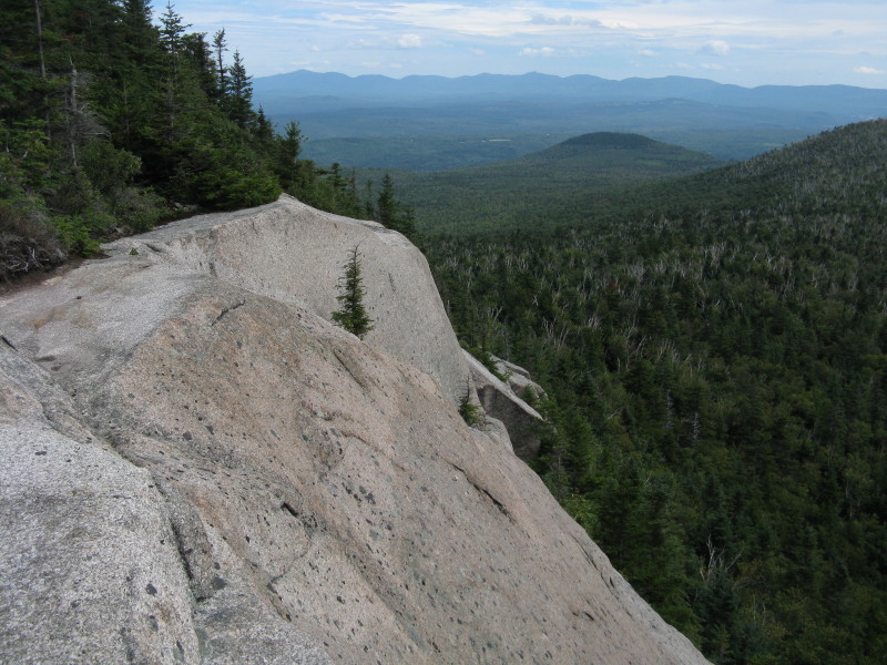
Arriving at the summit, we had our first peek out at the great granite shelf atop the Rogers Ledge cliff.

We followed a short side path out to the shelf, where we found a refreshing breeze. We had passed one pair of runners and one camp group of backpackers on the way in, but, as is often the case, there was no one here when we arrived.

Behind the cliff is a small plaque bearing the name of the mountain. It was placed there by the Rt. Rev. Robert McConnell Hatch, an Episcopal Bishop from Connecticut and Massachusetts, and his friend Jack Farr, who spent many happy days exploring The Kilkenny in the 1950s and 1960s. Bob Hatch led a campaign to change the offensive former name of this mountain and succeeded in having it renamed for Major Robert Rogers of Rogers' Rangers fame (in the French and Indian Wars). His eloquent story about that effort appeared in the December 1965 issue of Appalachia.

Rogers Ledge is, simply, one of the great perches in the White Mountains. The view east looks beyond little Round Mountain to the long profile of the Mahoosuc Range.
 Nearby to the SE is birch-cloaked Deer Ridge.
To the south the Carter Range and Northern Presidentials rise beyond the Crescent Range and the upland plateau at the base of Rogers Ledge.
 With a zoom lens or binoculars there's a great look into King Ravine under Mt. Adams.
 Close by to the SW is the broad-spreading "Unknown Pond Ridge," with the peaks of The Horn and The Bulge peeking over on the R. The Kilkenny Ridge Trail climbs over this mountain between the main summit and a lower NW spur. If you look closely at the base of this ridge you might catch a glimpse of little Kilback Pond, which the KRT passes in a muddy but very beautiful section.
 To the west is the wild, trailless ridge of the northern Pilot Range, with Hutchins Mtn. prominent on the R. The beaver meadows down below look promising for moose spotting, though we didn't see any.
 This ledge was made for summer snoozing.
After a relaxing two-hour sojourn atop the cliff - during which no other hikers came by - we paid a visit to the true summit, located just a short distance away and bearing a benchmark.

The summit ledge also has a good view south.
 This slightly higher vantage point reveals the summit of North Weeks and the ridge leading out to its east knob.
Apparently a moose was enjoying the view at some point.

Heading back down the trail, we again marveled at the birch-and-fern glades.
 Before heading down the valley, we left the trail and bushwhacked towards the North Peak of Rogers Ledge. I had snowshoed to ledges on this small summit with friends in the 1990s and wanted to pay a return visit. Wooded cliffs loomed at the base of the peak. Carol waited here while I made a fairly steep and thick whack up a gully between the cliffs.
 On the east flank of the North Peak I emerged on a clifftop with an open profile view of trailless Square Mountain, which boasts the largest cliff face in the Kilkenny, and is a nesting site for peregrine falcons.
 After our hike, it was interesting to read an account of a trek in this area in the December 1888 issue of Appalachia. In the final of a three-part installment about explorations in the Pilot Range, noted AMC trailbuilder William H. Peek recounted a July trip into the "Peaked Hills," the name then used for the small, steep-faced mountains in the northern Kilkenny region. Peek's party of four (which also included Eugene B. Cook) climbed Mill Mountain on the first day. The next day they visited the Devil's Hopyard and South Pond (then known as Percy Pond), then followed a logging road northward. After a "considerable scramble" they reached the summit of Peaked Hill (North), known today as the North Peak of Rogers Ledge. He described the views of Square Mountain (then called Green's Ledge, a name now applied to the smaller cliff-faced mountain east of Square) and south to the Presidentials between the ridges of Peaked Hill (South) (today's Rogers Ledge) and Deer Mountain (today's "Unknown Pond Ridge"). After camping below the North Peak, the third day they climbed Square Mountain and bushwhacked out through logging slash and along logging roads out to West Milan.
After pushing through some dense growth I found a small south-facing ledge where I could look over at the wooded backside of Rogers Ledge/"Peaked Hill (South)".

There was an unusual view of the Northern Presidentials framed by the ridges of Rogers Ledge and Unknown Pond Ridge.

From here you can see the entire sweep of Unknown Pond Ridge, too long to capture in a single photo. The old Deer Mountain name that was used for this eminence now resides on the lower ridge nearby to the east.

We returned to the trail and savored the mostly easy walk out through the beautiful Kilkenny woods. This is an area that beckons again and again.
 The round trip to Rogers Ledge from South Pond is 8.2 mi. with 1850 ft. of elevation gain.
No comments:
Post a Comment