
Some of our favorite trails are in the fine network branching out into the Sandwich Range from the Ferncroft trailhead in Wonalancet, most of which are admirably maintained by the local Wonalancet Out Door Club. On this day the forecast looked better to the south, and it turned out be be a beautiful cool, partly sunny day.
We arrived at Ferncroft with no definite plan in mind. At the trailhead we decided to head up the Kelley Trail, which leads through a scenic and geologically interesting brook ravine. From there we would have options to climb Mt. Paugus to the east or loop over the Wonalancet Range to the west.
 The hike starts off on the wide woodsy corridor of the Old Mast Road.
Just after turning off on the Kelley Trail we passed this interesting rock with a small tree growing on its flank.
 The Kelley Trail climbs gently up the valley of a small brook shaded by towering hardwoods.

After climbing up the slope above the brook,you enter the Sandwich Range Wilderness.

The trail comes back to the tiny brook, variously called Cold Brook or Kelley Brook, and follows it through a wonderfully secluded little ravine. In some places miniature meadows border the stream.

One of the several crossings is made over nicely placed rock slabs.

The brook here was once much larger. At the end of the last Ice Age, there was a meltwater lake in the broad Albany Intervale on the north side of the Sandwich Range. For a time the eastern outlet of the lake, where the Swift River flows out now, was blocked by an ice dam, forcing the water to pour down through the Kelley Trail ravine. This powerful surge carved out several small gorges and amphitheatres, where little flowing water is found today. The trail leads by several of these interesting rock formations.
 We took a break in this elfin streamside glade.
 Farther up, the brookbed went dry, and we clambered up over slippery rocks.
At the head of the valley we climbed steeply out of a small natural amphitheatre known as the "Pleistocene Plunge Pool," where once there was a high waterfall.

We saw some good axework by the WODC crew.
 We soon reached the little cut that is the gateway to Paugus Pass, the low point on the ridge between Mt. Passaconaway and Mt. Paugus.
The pass is marked by a four-way trail junction.

Having decided to tackle the steep climb up the "Wonalancet Hedgehog" on the Walden Trail, we headed west on a gentle leafy stretch of the Lawrence Trail.
 We soon arrived at another quadruple trail junction, this one officially known as "Four-Way."
The Walden Trail immediately begins a steep climb, at first on a series of rock steps. This trail, which had become severely eroded, was largely reconstructed by the WODC from 1997-2001. Over 10,000 hours of work went into the project, and over 500 rock steps were placed.
 There is a series of short, steep scrambles, with gravelly footing adding to the challenge.
 Partway up there's a peek back at the wild cliffs and gravel slopes on the SW flank of Mt. Paugus.
This broken ledge is the trickiest spot on the steep climb up Wonalancet Hedgehog. Luckily it has good footholds and handholds, though I wouldn't want to do it in the rain.

Early AMC guides mentioned a side path to a small flume somewhere along this stretch of trail. A few years ago I found it, though it might take some doing to locate it again.

The trail levels on the shoulder of the Hedgehog in fine softwood forest.

Then you climb steeply again, scrambling up this slab at the top of the pitch.

Here a side path leads right to a fine viewpoint looking east to the wild sprawl of Mt. Paugus, with Mt. Chocorua peering over in back.

 The NE view looks out to the Moats, Kearsarge North and the distant Baldface Range. This is a great place for a break after the steep climb.
 Easy climbing led us to a side path near the summit of Wonalancet Hedgehog, leading 100 yards down to a clifftop perch with a sweeping southerly view.
 From here there's a good perspective on the Ossipee Range, with the fields of Wonalancet in the foreground.
 Our next two objectives, Hibbard Mtn. (R) and Mt. Wonalancet (L), could be seen nearby to the SSW. These peaks and the Wonalancet Hedgehog make up the Wonalancet Range, which is a southeastern extension of Mt. Passaconaway.
A large boulder marks the 3140-ft. summit of the Hedgehog. Many years ago I somehow managed to scramble up on this, but it's too much work for a repeat visit.
 Gentle walking along the flat crest of the Hedgehog brought us to the Wonalancet Range Trail.
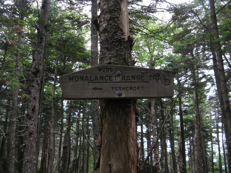 The upper section of this trail, leading down towards Hibbard Mtn., is delightful wooded ridge walking, with easy grades and soft footing.
The climb to the little ledgy 2940-ft. summit of Hibbard is trivial. Unfortunately what was once a dramatic vista of Mt. Whiteface rising from the depths of The Bowl has become increasingly obscured by trees, even when standing on the top of a tippy boulder. In late winter, with deep snowpack, the view is improved.

A short distance down the trail a short side path left leads to a ledge with a good open view south.

The wooded hulk of Mt. Wonalancet is just ahead.

The moderate descent off Hibbard leads through beautiful spruce woods.

We opted to continue on the Wonalancet Range Trail over Mt. Wonalancet rather than take the sidehill "Short Cut" trail that bypasses the wooded summit (2780 ft.) and the view ledge down on the mountain's flank. Along the easy climb to the top of Wonalancet we passed this gnarled old maple in a high hardwood glade.

From the summit the trail descended fairly steeply to the slab at 2550 ft. Here there is a wide lowland view to the SE....

...and a neat look at Paugus and Chocorua.

The descent below the view ledge is wickedly steep and rough -- slow going.
 It continues that way for a while below the lower junction with the Short Cut.
 Once into the hardwoods, things get a little easier, though the footing is rocky at times. In one section the trail leads through an interesting collection of boulders strewn all through the woods.
The last half-mile or so of the descent is very mellow with good footing. This 7-mile loop hike, with 2250 ft. of elevation gain, was just right - an interesting ravine, wild and beautiful woodlands, several good views, and some challenging ascents and descents. Highly recommended!
WODC does do a fine job of trail maintenance. I was up on the Sleepers this weekend and they do a fine job of keeping the trails clear throughout the Sandwich Range. I wish there were more small clubs like them still in existence. Big is not necessarily better.
ReplyDeleteWODC does a great job on the trails, and they have an interesting newsletter and a great map. It is a great benefit to hikers that small clubs like WODC, RMC, WVAIA, CMC and CTA each looks after a fine network of trails on their home turf.
ReplyDeleteSteve
The Wonalancet Range Trail is no longer accessible from the Hedgehog. Looks like blowdowns from Hurricane Irene? might be responsible for closing the upper part of the Wonalancet Range Trail.
ReplyDeleteThanks for the info. I hadn't heard about this blowdown. Has that section of the trail been closed?
ReplyDeleteSteve