
The ascent of Mt. Tecumseh, the lowliest NH 4000-footer at 4003 ft., is longer and a bit more strenuous via the NW approach from Tripoli Road than it is on the "front" side from the Waterville Valley Ski Area. But some hikers, myself included, consider the Tripoli Road approach to be a much better hike overall due to its beautiful woods, its interesting climb over West Tecumseh, and its lack of hiker traffic. This is the quiet side of the mountain.
This end of the Mount Tecumseh Trail starts from a parking area off Tripoli Rd., 5.7 mi. up from I-93.

After crossings of Eastman Brook and a tributary, the first part of the trail climbs easily, then moderately with good footing, through a fine mature hardwood forest.

Higher up there are some large old yellow birches.

Above 2400 ft. white birches enter the forest mix. More good walking here.

At about 3000 ft. the trail eases off on a plateau between West Tecumseh and a 3156-ft. spur that was once on the 3000-footer list. Beautiful open mixed woods here, with plenty of ferns.

The trail turns L and after a while climbs more steeply, with a few mildly rough pitches.

You top out at the west end of the 0.2-mile long crest of West Tecumseh, where a side path leads up to a view of Mt. Moosilauke from a densely grown blowdown area.

The trail meanders along the wild ridge of West Tecumseh, passing through blowdown areas and climbing over several minor knobs.
 The actual summit of West Tecumseh is just off the trail at the E end of the summit ridge. For a few years this peak was on the New England Hundred Highest list, but a new USGS map in the early 1980s showed that it came up short for the 200-ft. col requirement with its parent peak.
There's one pretty steep and rough section on the climb up to the summit of Mt. Tecumseh itself.

About 0.1 mi. below the summit, there's a ledge on the east side of the trail that offers a restricted but interesting view N.

Beyond the nearby humps of Scar Ridge you look out to the peaks around the western Pemigewasset Wilderness, including the four Franconias, Owl's Head and Mt. Garfield.

By leaning a little you can spot Galehead, the Twins and West Bond.

From here it's a short climb to the summit ledge and cairn.

The eastern view from the ledge beside the cairn seems to have improved in recent years. There's a fine look into the remote backcountry N and NE of Waterville Valley.
 The Tripyramids take center stage to the E.
Down in front you can see the Sleepers and Mt. Whiteface.

And from a little side path there's a peek out to the Osceolas with Mt. Carrigain and the Presidentials between them.
 I wanted to check the outlooks on the Sosman Trail along the mountain's south ridge. It had been a while since I had descended the upper part of the Mount Tecumseh Trail on this side. This little segment drops steeply, then swings around the base of the summit cone.
There's one peek-a-boo view of Sandwich Dome.
 In 0.2 mile from the summit I reached the second junction with the Sosman Trail (the first being at the summit). Ascending from Waterville, L is Sosman Trail, R is Mt. Tecumseh Trail, both leading to the summit.
A short, flat walk leads to the third Sosman/Mt. Tecumseh Trail junction.

I continued south along the level ridge on the Sosman Trail.

A short, rocky climb leads to this view back at the steep cone of Tecumseh.
 Just ahead is a NW outlook that is growing up but still good if you stand.
Moosilauke is the most prominent feature of this vista.

Mt. Wolf can be seen beyond the crest of West Tecumseh with its fir waves.
 A few yards farther along the Sosman Trail is an eastern outlook, where a bench that once provided a resting place has fallen victim to the harsh mountaintop climate.
This vantage point has become seriously grown in over the last few years.

But you can still get some decent standing views through gaps in the trees.


I retraced my steps back along the Sosman Trail, then followed it up along the west side of Tecumseh's cone, where an opening provides a western view. Mt. Kineo (L) and Mt. Cushman (R) are prominent in the center, with the Green Mountains on the horizon.

There are numerous talus patches on the steep slope of the long SW ridge coming off West Tecumseh. Moses Sweetser's 1876 guidebook called this "Mt. Avalanche." I made a long bushwhack up Haselton Brook to visit one of these about ten years ago.
 After a brief re-visit at the summit of Tecumseh, I descended to the col and climbed back up to West Tecumseh. On the way back I hoped to find some small ledges on the shoulder of this ridge off its west end. The direct approach from the summit crest looked like an impenetrable mess of scrub and blowdown. A flanking maneuver was in order to avoid this tangle.
As luck would have it, my circling route brought me out to the top of a triple-decker ledge I had spotted from the Sosman Trail west outlook. From a distance it had looked like a giant natural cairn.

This spot had a unique view of the wild backside of Tecumseh, rising at the head of the Haselton Brook valley.

The Tripyramids were nicely framed through the Tecumseh-West Tecumseh col.

Looking down the valley, the several trailless ledgy SW spurs of the Tecumseh range were in view. Welch and Dickey Mountains can be seen in the middle distance, in the center of the photo.

A closer look at those wild spurs. The rocky one in the foreground is, I believe, what guidebook editor Sweetser referred to as "Spring Mtn.," because a mineral spring house was located at its base in the late 1800s. Sweetser outlined three routes up Tecumseh from this valley, one of them going up over Spring Mtn. In the mid-1990s two friends and I made a snowshoe journey up the Haselton Brook valley and visited the first three sets of granite ledges on "Spring Mtn."

The triple-decker ledge also had a fine distant view to the south. I could see the sun glinting off many cars heading north on I-93 for the long July 4th weekend.
 I returned to the trail and enjoyed the descent down to the plateau at 3000 ft., where there were long views into the forest.
 Down in the hardwoods I stopped to admire this unusually-formed maple. On this gorgeous Friday before a holiday weekend I saw only one family of three and one solo hiker, both at the summit of Tecumseh. I met no one along the trail from Tripoli Road, in either direction. The quiet side, indeed.
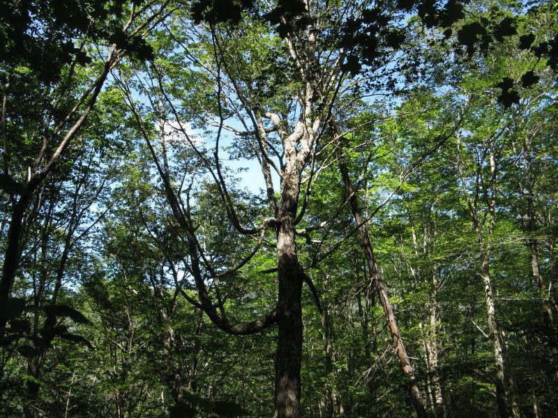
Great photos Steve. It's easy to follow your hike with them. I've got to try that in my own trip reports.
ReplyDeleteThanks, Phil - keep up the great work on scetionhiker.com!
ReplyDeleteSteve