The Dry River Valley has long held a special fascination for me. This huge basin on the south side of Mt. Washington, between the
Southern Presidentials and Montalban Ridge, has an aura of remoteness,
mystery and even spookiness, perhaps harking back to Nathaniel
Hawthorne's story, "The Great Carbuncle." From 1892-1898 the valley was logged by crews working for the Saco Valley Railroad, which ran a tortuous course up the canyon-like lower half of the valley, crossing the river 13 times on trestles. This misnamed river rises fast and furious after heavy rainfall, and the trestles were washed out within a few years after the railroad ceased operations.
When it was opened in the 1930s along the bed of the railroad, the Dry River Trail also had numerous
crossings. But after two hikers drowned in 1971, a footbridge was built at the first crossing and
numerous relocations were made to eliminate most of the other crossings.
As a result the trail sports many rough ups and downs, making it much more
difficult than a typical valley trail.

In recent years the Dry River Trail has been ravaged by three epic storms: Tropical Storm Irene in August 2011, the "Halloween Storm" of October
2017, and a prodigious rainstorm just last December. The floodwaters of these storms doubled the
width of the river in many locations and wiped out several sections of
the trail bed. After Irene and the Halloween Storm, the USFS Saco Ranger District made several new steep up-and-down relocations, making
the trail rougher than ever. The Halloween Storm also added a sketchy crossing of a loose gravel slide beyond the Mount Clinton Trail junction.
The December 2023 storm caused still more washouts, including a major one about a mile in on the trail, which I took a look at in January. I had seen reports of a new relocation there, and of a second gravel slide crossing beyond the one mentioned above. I wanted to check out these new features for future trail descriptions. Combined with a bushwhack farther up the valley to a hidden cliff with an unusual view, it would make for a rewarding full day's outing.
Note: There are still a few short stretches of good
railroad grade walking on this trail, but overall it is quite rough with a number of narrow sidehill sections above steep dropoffs. It takes
significantly longer to walk than the stats would suggest. There are no major stream crossings in the first five miles, but the river must be crossed to connect to the Mount Clinton Trail or Mount Eisenhower Trail, and also on the Dry River Trail above Dry River Falls. These crossings are dangerous in high water. Though it is an alluring, remote Wilderness area for backcountry camping, it is not a suitable backpack for beginners. The USFS sign
in the photo is truth in advertising. As noted in the AMC White Mountain Guide, "Perhaps no other trail in the White Mountains better demonstrates the power of raging water."
The trail starts out innocuously with an easy half-mile through a fine hardwood forest. The area near the junction with the Saco River Trail was never logged.
The trail enters the Presidential Range-Dry River Wilderness at a huge washout caused by the 2017 Halloween Storm. This is Wilderness with a capital "W."
The river was significantly widened here.
When I came through here in 2021, there was a lovely cascade and pool at this spot created by the 2017 storm. The December 2023 storm rearranged the river again, and now this spot is mostly dry.
About a mile in, the new relocation splits to the left.
The old trail route to the right leads to this dead-end.

By necessity, the relocation ascends a steep sidehill, with poor footing, especially on the descent. The Dry River Trail has gotten a little more difficult, again.
After the new relocation, the trail skirts another washout, rather precariously. There is a muddy bypass around this spot to the left.
A startling view down to the river at yet another washout.
And another.
After a steep and rough up and down over a high bluff with a restricted view up the valley (fogged in this morning), the trail crosses the river on a suspension footbridge. The bridge has been damaged and repaired several times in the last fifteen years.
View upstream from the bridge.
There are numerous gravel slides along the steep slopes of the narrow lower Dry River valley. This is the largest of them, 300 feet long and very steep with a slope of 40 degrees. This slide is old, its lower part appearing in a 1939 aerial photo. It apparently expanded upslope sometimes during the 1960s or 1970s. In 1997 I bushwhacked to a smaller, higher gravel slope farther up the valley (which offered a unique view of Mount Isolation) and went partway up this one on the way back. Not surprisingly, the footing is very loose and treacherous.
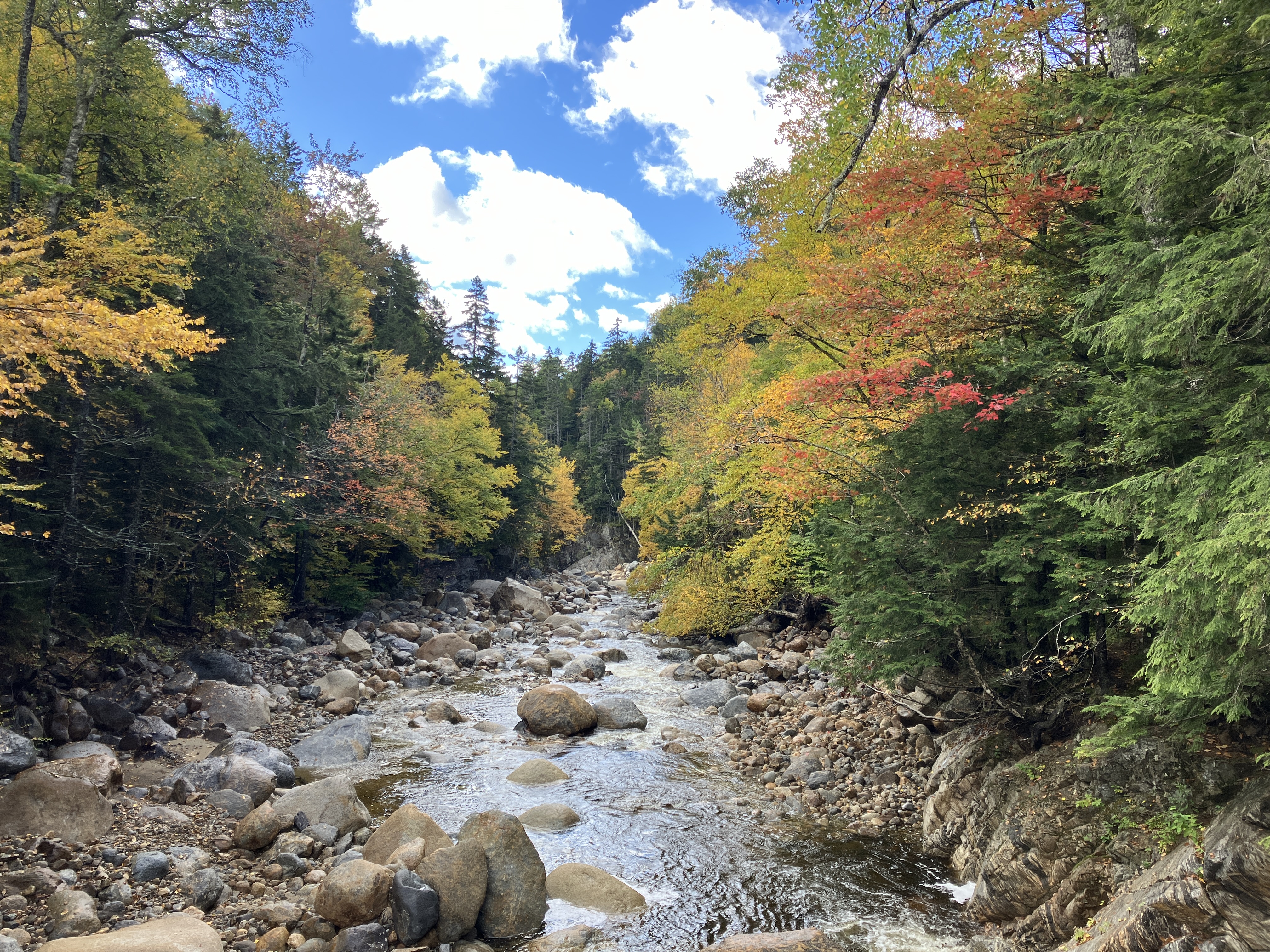
There are many scenic views of the river along the trail.
One of the few pleasant sections of railroad grade walking.
There are two steep, rough up-and-down relocations around washouts leading up to the junction with Mount Clinton Trail. The north end of the second relocation is a tad sketchy.
View downstream to Mount Bemis where the trail skirts the edge of a smaller washout.
I made a short side trip to check out the river crossing on the Mount Clinton Trail. Irene significantly widened the riverbed here in 2011, creating a vast field of rocks and gravel.
After crossing a water channel on the eastern side, which was a fairly easy rock-hop this day, the crossing follows cairns 100 yards north along the outwash area.
The route then crosses a water channel on the west side (newly created by the 2017 storm) and climbs a low, steep bank, marked by cairns, into the woods.
About 0.3 mile north of the Mount Clinton Trail junction, you approach the diciest stretch on the Dry River Trail, where you cross two steep gravelly washouts and tightrope across the top of a third..
The first of these washouts, opened by the 2017 storm, is the trickiest to traverse, as there are few reliable footholds.
There is a long drop to the river, a no-fall zone. In 2019 a hiker fell down this slope and sustained injuries serious enough to require a carryout.
In a few yards the trail descends across a second washout, carved out by last December's storm.
View from the washout.
It then descends along the edge of an older, revegetating washout.
A half-mile or so farther, I left the trail and began ascending the lower part of a long SW ridge off Mount Isolation.
After climbing a steep slope with mildly scrappy woods, I emerged in a gorgeous hardwood forest that I remembered from two previous whacks up this ridge.
A golden glade.
A champion yellow birch.
This steep pitch was the gateway to the obscure clifftop viewpoint. I hadn't been to this spot in 15 years, and hoped there would still be an open view.
There is!
Mount Carrigain and Mount Hancock rise beyond the canyon-like windings of the lower Dry River valley. Mount Whiteface, the Sleepers, and Mount Tripyramid are seen in the distance to the left.
Across the valley is Mount Jackson, seen from a unique angle that reveals a very broad profile.
A moose has apparently been checking out the view, too.
After an all too brief sojourn at the viewpoint, I did some spruce swimming to get down off this little knob.
Heading back down through those glorious hardwoods.
Inviting.
Colorful canopy.
Nice!
A neat ledgy spot back down on the river.
Dusk view of Boott Spur and cloud-wreathed Mount Washington from the bluff south of the footbridge. The Dry River Valley can beat you up a bit, but the rewards are great.


Lovely write-up and you caught some beautiful foliage! ~Brie
ReplyDelete