On yet another hazy, humid day I combined a hike up the Jewell Trail to the great viewpoint right at treeline with a bushwhack down to the upper part of a 2017 slide at the headwaters of Jefferson Brook's south fork. These choices fit the bill for the current high water conditions, as the stream crossings on the Jewell Trail are bridged, and the lower part of this slide would likely be impassable due to the surging waters of Jefferson Brook.
I would not have wanted to cross the Ammonoosuc River on this day.
The lower half of the Jewell Trail is unusually smooth walking for a route in the Presidentials.
A rockin' cascade by the bridge over Clay Brook.
Many log steps on the climb above the brook.
Sun-dappled fir forest.
A peek at Mt. Eisenhower from a blowdown/fir wave area.
The Mount Washington Hotel stands out in the distance.
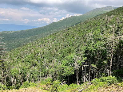
Nice boreal forest up around 4000 ft.
The descent to the slide at the head of Jefferson Brook's south branch was slow and cautious through an area of blowdowns and hidden holes.
Found the slide!
As seen on Google Earth's 2018 image, the upper part of this slide is trident-like, with three prongs. The left (eastern) prong is older and may have fallen in the October 1995 storm. The slide shown here is the western prong and surged down this valley during the October 2017 "Halloween storm." The smaller middle prong apparently was triggered by the same storm. The slide opens a view north to Mts. Starr King, Waumbek and Cabot.
I descended partway along this upper section and found a comfortable rock seat for a long lunch break. This was the view looking back up.
I really liked the unique perspective on the Ridge of the Caps rising to the summit of Mt. Jefferson. The famed light-colored "pothole ledge" can be seen on the far left.
Closer look at the Caps.
After lounging in the hazy sun for a while, I carefully descended to a point near where the three upper prongs of the slide meet. The pitch shown here is very steep, about 37 degrees, and I engaged in some butt-walking to get down it.
Looking back up.
From here there was a nice view to the NW, including Mt. Dartmouth and Cherry Mountain on the left. I could also see a little way down the scoured track of the slide, which extends more than a half-mile (!) below here.
Side view.
I picked my way across a narrow band of trees to rocks just below the point where the eastern (on the left) and middle (on the right) prongs of the slide merge. Wild terrain in here!
Looking up the eastern prong.
Looking down the combined track of these two prongs. A good flow of water here even at 4000 ft.
Bunchberry blooming beside the western prong.
Climbing back to my lunch spot.
Uh oh, dark clouds rolling in. Time to pack up.
A refreshing rain shower moved in just as I was leaving the top of the slide to whack back up to the trail.
I found a route with better woods than my descent route.
But there were plenty of wet ferns to give me a good soaking.
This patch of woods had a primeval look to it.
By the time I got back to the trail, the sun had made made a return appearance.
I continued up the trail to treeline to get some wide views, and to dry out a little bit in the sun and breeze.
The Jewell Trail abruptly pops into the open at 4600 ft., and right there is a cluster of rocks that provides a great viewing perch.
I hung out here for quite a while enjoying the hazy view, a main feature of which is the Southern Presidentials.
Across the gap of Burt Ravine is a long slide that fell during the 2017 Halloween storm. I climbed that one last summer, ending up on the Cog Railway service road.
Clouds were playing around the peaks.
Mt. Jefferson to the north.
I watched a couple of Cog trains descending. During my sojourn I exchanged greetings with numerous hikers descending via the Jewell Trail.
For the traditional railroad buffs, at 4:00 pm the Cog does a special run of the older coal-fired engine with its trademark black smoke.
Ominous clouds and a rumble of thunder to the south. Time to head down. Luckily it stayed to the south.
Partway down I bushwhacked from the trail up to the crest of the ridge and out into a fir wave area, where a faint moose path was evident.
Here I found a unique view of Burt Ravine and its two major slides - the aforementioned 2017 slide, on the right, in the south branch of the ravine, and an older gravel slide, perhaps from the October 1995 storm, on the left, in the north branch of the ravine.
The rocky swath on the left and the thumb-like protrusion on the right were added during the 2017 Halloween storm.
A nice angle on the 2017 slide in the south branch of the ravine, with Mt. Monroe rising beyond..
Last look at the Southern Presys and the Willey Range before heading back to the trail and home.


No comments:
Post a Comment