Joined Ray "Jazzbo" Caron, Dan Newton and Dan's canine companion,
Friday, for a bushwhack route that included an ascent of the big SW
slide on Mt. Osceola. It was a day to remember.
Making the initial approach on Waterville Valley X-C ski trails.
We bushwhacked alongside the impressive boulder train that the slide deposited a mile and a half down the valley.
Ray leads the way through open hardwoods on a southern ridge of Osceola.
We came upon a most unusual tree.
Pleasant whacking continued.
We crossed this clear old sled road running across the slope, probably from Parker-Young Co. logging operations in the 1940s.
High up in the valley we followed another old sled road, mostly overgrown with prickly small conifers.
We dropped down to the outflow brook not far below the slide.
Making our way up the brook.
A massive ledge slab - too steep and wet to climb - guards the bottom of the slide proper. We found a route around it.
Dan emerges at the top of the slab.
Taking it in.
First look up at the main part of the slide.Yikes!
Dan does some botanizing at an island of vegetation.
Great find by Dan - one of several colonies of sundew, a tiny carnivorous plant.
View out to Sandwich Dome and the Green Peak ski trails on Mt. Tecumseh.
There were deer tracks in the gravel!
This slide is expansive. In a 1958 study of White Mountain landslides and their revegetation, Edward Flaccus measured the slope of this slide as 29 degrees on the average with a maximum of 34 degrees. It was 367 yards long with an average width of 75 yards, and covered 5.7 acres, with its track extending 1.5 miles down the brook. He estimated that 29,724 tons of debris were moved by the slide. This was one of 6 slides that crashed down the slopes of Osceola during Hurricane Carol on August 31, 1954. There were also two in the ravine of Osceola Brook (which I visited this spring) and three on the northern slopes.
When Mark Klim and I visited this slide three winters ago, these slabs were cloaked in picturesque icefalls.
Wide slabs.
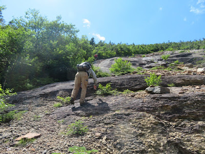
Making our way up, paying careful attention to footing.
Ray is enjoying it.
Down-look.
Early-blooming asters.
A bit more than halfway up the slide, a shelf beckoned for a long lunch break.
Summertime, and the livin' is easy.
Ray savors the lunchtime vista.
On the lookout.
The ledge-dotted summit of Mt. Osceola looms above.
Heading up.
Dan checks photos....
...then scrambles up one of the steeper pitches on the slide. The ledges were dry and grippy on the upper slide.
Tripyramids and Scaur Peak in full view, with the Sleepers and Mt. Whiteface to the right.
Now on the other side, Dan and Friday are tiny figures in the slide-scape.
Zoomed.
Top of the slide.
View from the top.
Dan says that bushwhacks are sweet and sour. The whack from the top of the slide to the Mt. Osceola Trail was the sour part. It took more than an hour for a mere 0.3 mile.
The guys are smiling because we can actually see each other for a moment.
We looped up onto the crest of the ridge in hope of better going, and instead found massive blowdown.
After we emerged from the claustrophobic conifers onto the open trail, we felt like we could almost glide to the summit.
When we arrived at the top, the only occupant of the big summit ledge was a raven, apparently admiring the view.
It was a spectacular summer evening on one of the best summits.
Perfect.
Dan points out the slide down in the Osceola Brook ravine.
The mighty Carrigain.
Pemi Wilderness vista, obtained by descending a short distance on the trail towards East Osceola. This northerly view is now better then the increasingly obscured vista on the side path by the true summit. All told, you can see 41 NH 4000-footers from the Osceola summit area.
We had the place to ourselves for most of our 50-minute summit stay. Then it was time to make the rocky descent to Tripoli Road, followed by a headlamp walk down the road to the Waterville Valley end, as we had not spotted a vehicle at the Osceola trailhead. We reached our vehicles at 10 pm, footsore but happy.


Tremendous! Great view of the Pemi wilderness. Offers a clear reminder why climbing Garfield from the east is tough going.
ReplyDelete