
FIRST SISTER: 2/21/17
It was a good day for views up on the ridge of Mt. Chocorua! I Microspiked up the familiar Champney Falls Trail, went partway up the cone of Mt. Chocorua until it got icy, then snowshoed up to First Sister and took in the 90-mile vistas for an hour and a half.
Despite the recent thawing, there was still good snow depth at the trailhead.

Twin Brook was solidly buried. Sadly, that will be changed by the forecasted spring-like weather spell.

Champney Brook, beside the trail.

The track on the trail was solidly frozen, but choppy with numerous boot divots and occasional deep postholes, most likely created on Sunday when temps soared into the 50s.

Some backcountry skiers had been on the trail as well.

An open glade at 2750 ft., along the first of the upper switchbacks on the Champney Falls Trail.

Some serious sidehilling on the switchbacks.

The sidehilly Middle Sister Cutoff (aka Champney Falls Cutoff) was unbroken and uninviting.

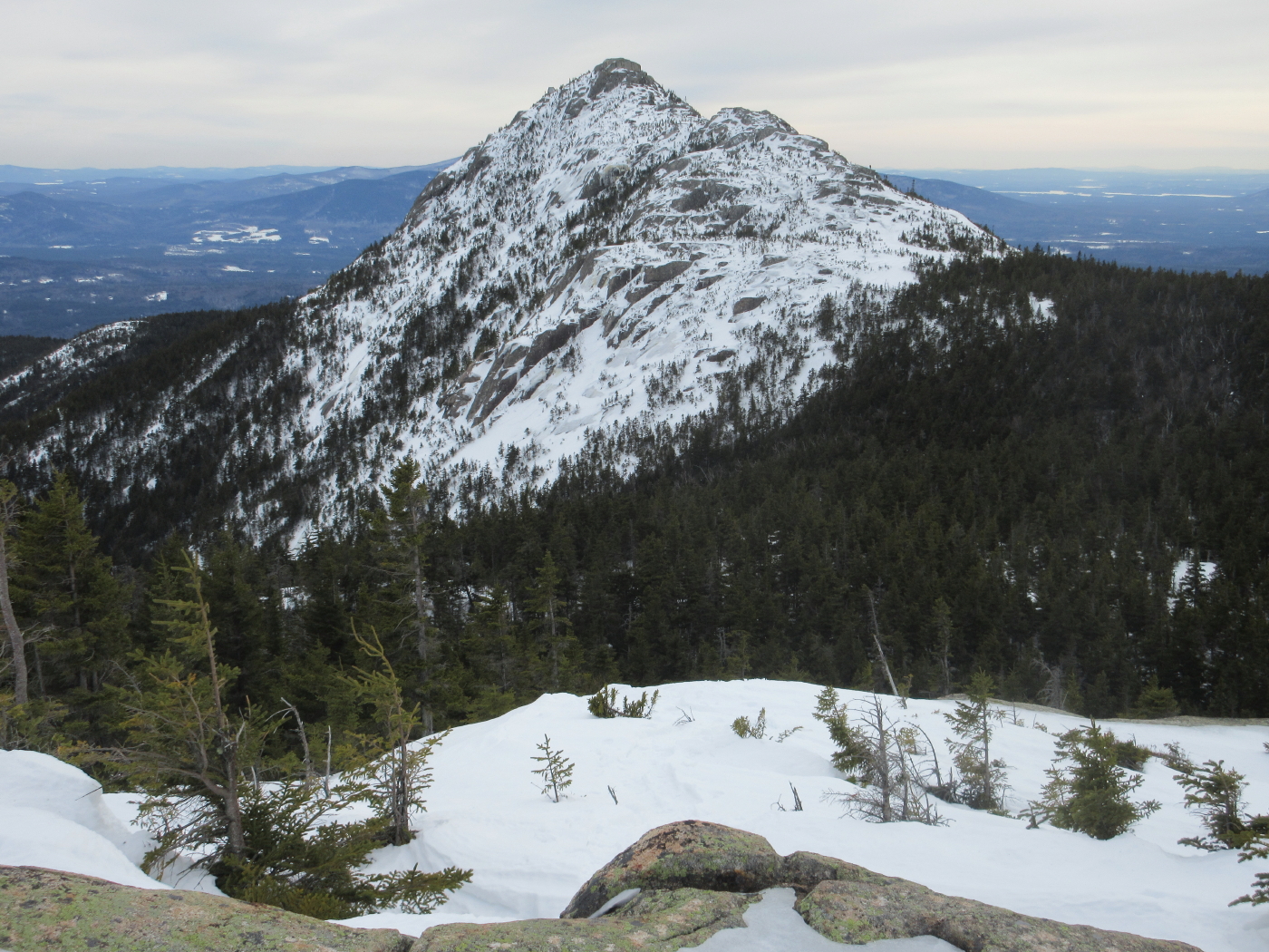
Just before the Champney Falls Trail reaches the ridgecrest, a side path leads to an excellent open ledge viewpoint, which provides this look at nearby First Sister.

Subalpine terrain encased in crusty snow.

Passaconaway and Tripyramid.

What a day!

The Presidentials shone as a snowy beacon to the north.

The major junction where the Champney Falls & Piper Trails meet.

I followed the Piper Trail along the wooded ridgecrest towards the summit of Mt. Chocorua.

After passing the West Side Trail, Piper Trail emerges in the open.

Western view across a snowslope.

Looking back at First Sister and the Presidentials.

I picked my way partway up the cone of Mt. Chocorua until I hit some tricky ice patches. I was wearing 'spikes but did not have full crampons with me as I was planning on only doing First Sister, so it was time to turn around.

A framed view of the Presys.

Sighting on the Sandwich Range.

Peering down the Bee Line valley, cloaked in hardwoods.

Heading back across, I snowshoed up the Middle Sister Trail towards First Sister, following a previous snowshoer's tracks from a couple of days ago.

Looking back at the sprawling Sandwich Range.


Approaching the broad, open summit of First Sister.

The north view down the Champney Brook valley from the top of First Sister. The summits of 33 4000-footers can be seen from here.

The western view from First Sister.

Looking across at Middle Sister, its summit adorned with the foundation of an old fire lookout station, and a new radio repeater used by the Forest Service.

The southeast view beyond Carter Ledge. The buildings of Portland, Maine were visible on the horizon. The most visible distant point seen on this clear day was Mt. Monadnock, 86 miles south.

Deep snowpack on an off-trail ledge.

A gateway vista.

The impressive horn of Chocorua.
The outlook ledge near the top of Champney Falls Trail is part of the big white patch seen on the right in this photo.

On the way down I attempted to descend the loop path alongside Champney Falls. These overhanging ledges guard the east side of the brook.

Snow-topped rocks at the top of the falls.

Halfway down the loop I came to this dangerous icy chute covering a rock staircase. I retreated and climbed back to the main trail at the top of the falls loop and headed down from there.

No comments:
Post a Comment