
THE BACK DOOR TO MIZPAH: 9/26/16
On a spectacularly clear fall day, Mark Klim and I took the long route from the Dry River Valley to Mizaph Spring Hut and Mount Pierce, 6.8 miles to the summit. The notoriously obscure Mount Clinton Trail lived up to its reputation, if only in its lower half-mile.
We had a mix of morning sun and shade along the lower part of the Dry River Trail. Surprisingly, a group of three redliners also heading for the Mount Clinton Trail pulled up to the trailhead on Rt. 302 as we were getting geared up. They left ahead of us and hopefully had a good hike.

A washed-out bank along the first of several trail relocations necessitated by damage from Tropical Storm Irene.

The classic view from a bluff along the Dry River Trail: Mount Monroe, Mount Washington and the headwall of Oakes Gulf.

Suspension bridge over the river.

More Irene damage.

One of the few bits of railroad grade walking left along the Dry River Trail. The Saco Valley Railroad operated from 1892-1898 and crossed the Dry River 13(!) times.

One of the rougher relocations cut around washouts from Tropical Storm Irene.

A new junction with Mt. Clinton Trail, a short distance SW of the old one.

The riverbed is twice as wide here as it was before Irene. The water level was low, as expected, and the crossing easy. In high water, forget it. We took a long break in the morning sun on the far side.

Looking downstream along the widened river.

A nice place to hang out!

To find the trail on the west side of the river, we followed cairns about 100 yards north along the outwash and rocky rubble.

Here's where the current route hops up into the woods. Then, following orange flagging with little discernible footway, we went 15 yards to the right, 15 yards to the left, then 30 yards again to the right to meet the original trail route (which, going back, shortly ends at a high washed-out bank).

The trail was overgrown but followable for 0.3 mile until it passed under a large spruce blowdown. Just past this obstacle, beaten paths led uphill to the left (with, as it turns out, bogus flagging) and downhill to the right. After investigating both of these at some length, it was obvious that neither of these was the trail.

The real trail continued across the slope but had no visible foot bed at this point and was disguised by what might have been a very old washout.

Once on the real trail, we soon came to the first of the 7 crossings of the brook that drains this remote valley (plus several additional tributary crossings). From here on there were no serious issues in following the trail.

There was a fine stretch through hardwoods along an old tote road after the first crossing.

Dropping down to the fourth crossing.

A nice little cascade and pool.

Yup, that's the trail.

An Irene washout along the brook.

High in the valley is this designated tentsite.

A peaceful brook crossing.

This fern meadow almost looked like an old logging camp site.

Colorful hobblebush hanging over the trail.

The junction with Dry River Cutoff, a half-mile below Mizpah Spring Hut.

A large random erratic high on the mountainside.

Beautiful boreal forest above the Dry River Cutoff junction. Aside from the route-finding issues down low, we found the Mount Clinton Trail to be a very pleasant approach with generally decent footing and a nice feeling of remoteness. The Saco Ranger District trails folks do plan to work on this trail either later this fall or next spring to clear out the problem areas.

Mossy!

Leaving the Wilderness.

Mizpah Spring Hut, opened in 1965.

Fall hut crew member Chris, who has visited my store a number of times, offers guests a friendly greeting. The turkey-and-rice soup and peppermint/chocolate pound cake were delicious!

From byway (Mount Clinton Trail) to highway (Webster Cliff Trail/AT).

One of two short ladders on the steep climb up the south side of Mount Pierce.
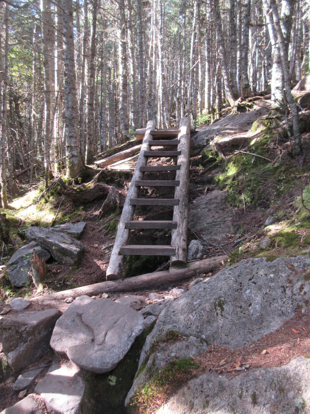
Steep and rocky.

My favorite spot on Pierce - the broad ledge with southwest views above the steep pitch.

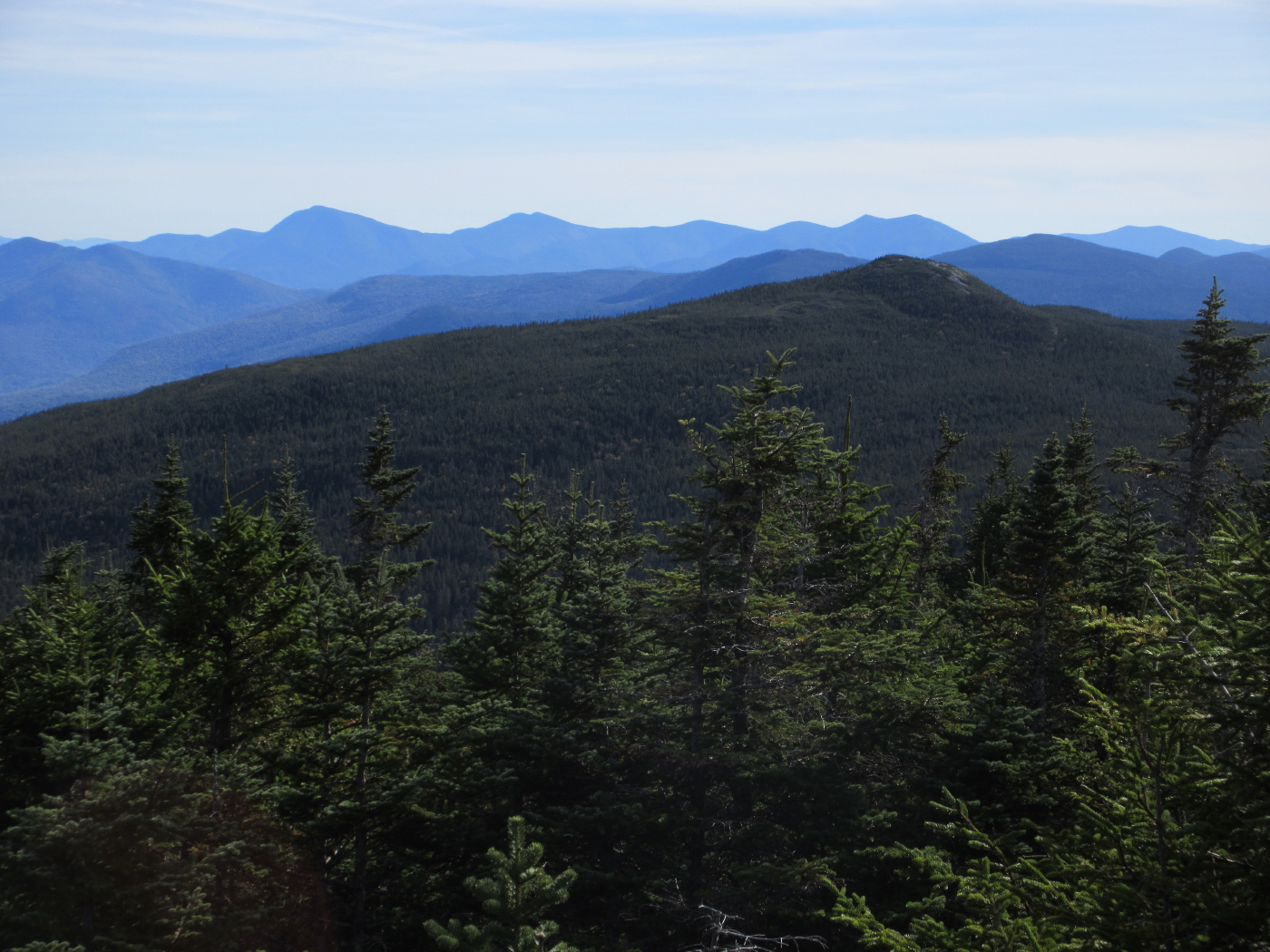
Looking out to the southern/central Whites.

Lower Montalban Ridge and Mount Chocorua.

The Sandwich Range beyond Mount Jackson.
Cheers!

Carrigain and Hancock.

An open ledge on the south summit of Pierce.

Summit benchmark.

Summit cairn.

Western view.

Ledge with a commanding Presy view.

Evening sun.

Across the upper Dry River Valley to Mount Isolation.

Time to head down.

Descending along the venerable Crawford Path.

Hi Steve,
ReplyDeleteI don't think I've ever seen a report on the Mt. Clinton Trail. Thanks for sharing. I'm shocked how much Irene damage is still out there. I wonder how many years it will take for the forest to overtake the damage and camouflage it as traditional forest again.
It was enjoyable to follow along on this trip through your pictures and captions. Thanks.
Karl
Thanks, Karl - as we were walking along the Dry River Trail we talked about what it would have been like to be there when Irene came roaring through, doubling the width of the riverbed in places. Amazing!
DeleteSteve
Great report - very useful for those planning to visit this area. I explored the Mt. Eisenhower Trail on Sunday and it was a really beautiful trail. I'm glad to hear that the Mt Clinton Trail is getting some love too.
ReplyDeleteThanks, Tim - I hiked the Mt. Eisenhower Trail last year and thought it was in excellent shape other than needing a trim along the upper part. Most of it has really good footing, especially for the Presys.
DeleteSteve