
MOUNT MOOSILAUKE VIA BENTON TRAIL: 6/4/15
On a fine sunny day I enjoyed an interesting hike with Linda Moore on a favorite trail, enjoying the quiet side of the Moose. We started around 9:00 am from the gate on Tunnel Brook Road after checking out a foundation from an 1800s sawmill beside the bridge over Tunnel Brook.

After several walks up the Irene-damaged portion of Tunnel Brook Road, I (and others) have still not been able to figure out exactly what's going on with the rehabilitation and subsequent decommissioning of the road. This part has been expanded to almost interstate width and slopes down towards the brook.

Currently you must either wade through this 200 yard mess of logs and branches, or bushwhack around it. I don't recommend this route for hikers or dogs until the planned bypass trail is cut. An injury is a real possibility.

Once past this oddly-placed sign, the road provides good walking for the last half-mile to the Benton Trail.

Along the next stretch we detoured into the woods to see some reminders of the interesting history of this valley, including these old gearwheels surrounded by foamflower.

It's always fun to visit this old car, identified as a 1926 Dodge coupe by photographer Erin Paul Donovan. That sounds about right, as the old road through Tunnel Brook Notch was closed by landslides in 1927.

Erin pegged this dashboard as a 1920 International truck.

We visited one more historic site - the foundation of the Parker House, a small inn that operated here from 1904 until around 1930.

One of the recent trail signs made of a composite material.

An old Dartmouth Outing Club hiker register, not in use anymore.

Due to rain earlier in the week, we had to wade the crossing of Tunnel Brook a short way in on the Benton Trail.

Looking downstream.

The beautiful hardwood forest along the Benton Trail above the brook crossing has long been a favorite trail section.

Sadly, logging is coming here, right up to the edge of the trail (blue marking), in this instance not even adhering to the paltry 20-foot buffer the Forest Service has designated along the route. Ironically, as the hiker enters the harvest unit there is a Forest Protection Area sign prohibiting camping within 200 feet of the trail and urging the practice of Leave No Trace. Yet there are numerous orange paint slashes on trees along the edge of the trail that will be visible for years. Sorry about the rant, I don't like to criticize the Forest Service, but it just seems wholly unnecessary to impact the trail like this....

After a left turn the trail continues up for a bit through hardwoods not marked for harvest.

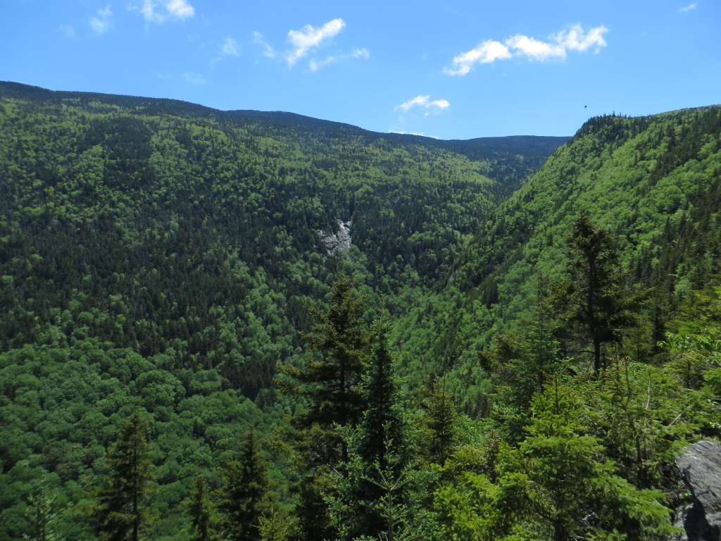
After an abrupt transition to conifer forest at 2400 ft., the trail continues up to a ledge outcrop overlooking Little Tunnel Ravine.

There's also a distant vista to the north.

The Kinsmans beyond a fir wave nub, with Mount Cabot on the horizon.

After a long break taking in the wild vista, we continued up through fine conifer forest behind the steep edge of the ridge.

Up at 4000 ft., some knuckleheads thought this was a cool way to camp. Not cool! We probably should have taken the time to dismantle it. but we were anxious to reach the summit.

A beautiful stretch of trail on a high shoulder.

The view from a western outlook at 4400 ft. This may have been the upper end of the long-abandoned DOC Tunnel Ravine Trail. The inimitable bushwhacker J.R. Stockwell went down from this spot, I think last summer. He said it was pretty rough going, and he did not find much trace of the old slide or the trail while dropping to the floor of the ravine.

Another level stretch with the summit ridge in sight ahead.

Lazy/thoughtless hikers have beaten a parallel path through the alpine vegetation as the trail climbs to the summit crest. It was a quiet afternoon on the summit, but of four parties we encountered at the top, I had to ask three to please stay on the trail and off the vegetation.

We wish more people would heed these signs.

Endless horizons to the north.

A marvelous walk along the broad and bare north ridge, with virtually no wind.

The classic summit sign shot, looking east.

The survey mark from the U.S. Coastal Survey station crew that occupied the summit in 1873 under the direction of Dartmouth professor E.T. Quimby. We thought the three circular gouges in the rock might have been for a tripod.

The more recent summit benchmark.

Linda captures the scene.

We found this neat rock behind the old summit house foundation. The top line reads "PROSPECT HOUSE," the original name for the summit hotel, and the bottom right line reads "1860," the year it was built.

We're not sure what these inverted "T"'s stood for.

A nice rendering of the summit hotel (renamed Summit Camp by DOC when they ran it from 1920-1942) adorns the top of this plaque.

Another plaque honors the two Dartmouth alums who donated the summit hotel and a circular tract around the summit to the college in 1920.

After two hours taking in the views over thousands of square miles, it was time to head down.

J.R. Stockwell once bushwhacked up that long bumpy north ridge of Mount Blue. Yikes!

In the emerald forest.

Quiet beauty abounds along the Benton Trail.

Shadows falling on Little Tunnel Ravine.

A forbidding cliff rises above the Nine Cascades, presumably the reason the tallest waterfall was sometimes called "Cliff Cascade." What a wild area!

No comments:
Post a Comment