
EASTER SUNDAY GEOCACHING: 4/5/15
Carol and I enjoyed a geocaching tour through the Baker and Connecticut River valleys with a nice variety of scenery on a chilly, partly sunny Easter Sunday.
We made our first few stops late morning in Rumney, including one at the Old Town Pound, where there is an impressive collection of boulders.

One of the day's most interesting caches was at the famous Warren Redstone rocket (aka the Redstone missile).

A nearby kiosk tells the story of how this unusual landmark came to Warren.

Farther along Route 25 we stopped at the "Old Man of the Dam."

Near here there was a fine view of the snow-caked South Peak of Mount Moosilauke. There were several inches of fresh snow up there, and that morning we had a two-inch snowfall in Lincoln.

Another cache took us on a short walk down to an old abandoned WMNF campground near Oliverian Pond, where Oliverian Brook was looking springlike.

The campground site is still maintained as an open area.

The Oliverian Pond dam is a fine vantage point for viewing the surrounding scenery.


Looking east to the South Ridge of Mount Moosilauke and Hurricane Mountain, Chokecherry Hill and Bald Hill.

We continued on to Haverhill Corner, where there was a cache in the beautiful historic district.

Then it was on to some border-hopping between New Hampshire and Vermont along the Connecticut River.

A fine view of the Benton Range and Mount Moosilauke from Newbury, Vermont.

Moosilauke and its South Peak, with the sharp nubble of Sugarloaf on the left.

Late in the afternoon we hiked up the Lackie Lone Oak Trail in Bath, which climbs to an overlook on private land protected by conservation easement by the Upper Valley Land Trust.

The south-facing trail was mostly dry and snow-free. It climbs 700+ feet in 0.8 mile. In its uppermost section the blue-blazed trail shoots up very steeply.

The outlook offers a long view over Woodsville and down the Connecticut River valley. The Middle Connecticut River Mountains - Piermont, Cube, Smarts, Moose - can be seen on the left. UVLT Stewardship Director Jason Berard notes that "from this lookout, you can see over 2,000 acres of UVLT conserved land. Nearly all of the farm fields visible in this photograph are conserved, as well as permanent public access to the Lone Oak Trail."
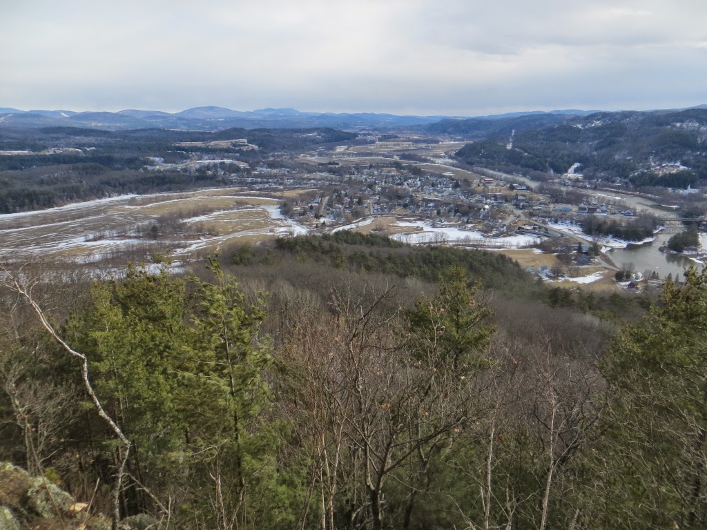
Moosilauke and the Benton Range are seen to the southeast.

Another great angle on the Moose and Benton (Tunnel) Ravine.

The "Lone Oak" from which the trail takes its name.

A nice perch to hang out for a while.

Evening sun on the Lone Oak Trail.

Wild turkey tracks in a patch of snow.

Carol heading into the Haverhill-Bath Covered Bridge, where we snagged our last cache of the day before heading home.

No comments:
Post a Comment