CATSKILLS - GRAHAM MOUNTAIN & BALSAM LAKE MOUNTAIN: 4/25/13
After considering several hike options for the final full day of our Catskill vacation, we decided to head for Graham Mountain, one of two 3500-ft. peaks located on private land. As recommended by the Catskill 3500 Club, we called the caretaker of this property, which is owned by the Gould family (of railroad fame in earlier days). We were fortunate to get through on such short notice, and permission was readily and graciously granted.
We turned off NY Rt. 28 at the Belleayre ski resort and navigated several back roads to the trailhead for the Dry Brook Ridge Trail on Mill Brook Rd. Along Mill Brook Rd. we enjoyed a good view of Graham Mountain in the distance.
At 2600 ft., this is one of the highest trailheads in the Catskills.
We followed the trail along an old jeep road for two miles through private land, climbing at moderate, then easy grades.
Private land is heavily posted in the Catskill Park, where there is a hopscotch mix of public and private holdings. But a trail easement provides access through here for hikers.The second mile of the trail rolls along at gentle grades.
At 2.1 mi. we reached the junction with the unmaintained trail (on the right in this photo) that leads through the Gould property to Graham Mountain. It should be emphasized again that to ensure future access, permission should be obtained before hiking this trail. Other than one sign at the beginning of this route, there were no more private land postings on the two miles across to Graham.
We were pleasantly surprised by the pleasant walking on this unmaintained route. It was easy to follow at this time of year, and other than the last steady half-mile, grades were quite gentle.
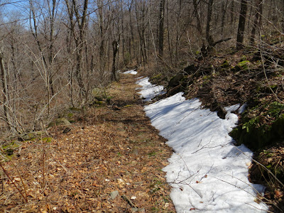
A remnant swath of snow along the first part of the route, which follows the historic Old Tappan Road.
There were some beautiful hardwood glades along the way.
A nice remote feeling out here.
As the trail climbed up the broad summit dome of Graham, it entered a forest of small, twisted hardwoods. In his excellent tome The Catskill Forest: A History (a must-have for devoted Catskill hikers), forest historian Michael Kudish makes note of the unique "pygmy" hardwood forest on the top of Graham.
A neat corridor leads onward towards the summit.
Near the top a short side path on the left opened a view over the pastoral Dry Brook valley.
The 3868-ft. summit of Graham is host to the remains of a 1960s vintage television relay station. Views from the summit clearing are limited to what you can see over the stunted hardwood trees. I knew there were open ledges somewhere around the summit of Graham, having seen pictures in the Catskill Forest book. So while Carol relaxed I embarked on an exploration around the rim of the summit crest, pushing through some dense brushy growth in places.
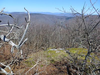
The ledges weren't where I expected to find them on the SW side of the summit, but I did find a good stand-up view looking west to the long, flat crest of Balsam Lake Mountain.
A beautiful beaver meadow could be seen to the SW in the remote valley of Gulf of Mexico Brook.
I thrashed my way around the south and east sides of the summit area, finding one framed view of Slide Mountain, King of the Catskills.
On the NE side I found a ledge with some excellent standing views, including this vista of Panther Mountain (R) and the eastern Devil's Path peaks (L).
There were some neat skeletal trees in the pygmy forest.
A look back at the NE view ledge.
On a second pass on the SW side of the summit I found a steep open ledge with a great 180-degree view, including this look at the wild, trailless Beaver Kill Range.
A view NW to Dry Brook Ridge.
A happy Catskill hiker on the way back across from Graham. Since we had some time (love these long spring days) and energy, we decided to make the side trip to the fire tower on Balsam Lake Mountain. The time I'd been there before, the views had been partly obscured by clouds, and I wanted to see them on a clear day. And this would be a new 3500 peak for Carol.
Balsam Lake was the site of the first fire tower built in New York State, back in 1887. The present tower was built in 1930 and was restored in 1998-2000 by a group of volunteers with help from NYDEC staff. (Click here for a history of the tower.) In summer and fall, volunteers under the leadership of Laurie and Tom Rankin staff the tower - click here for more info.
The view down from the top landing of the tower.
Hello down there!
No complaints about the views today. Looking south towards the Beaver Kill Range.
View NE and east towards Balsam Mountain, eastern Devil's Path, Eagle Mountain, Panther Mountain and Graham Mountain.
Looking north towards Belleayre, Vly, and Bearpen Mountains and Dry Brook Ridge.
West along Mill Brook Ridge.
Endless ridges lead out towards northeastern Pennsylvania beyond nearby Woodpecker Ridge.
Looking SE towards Doubletop, Lone, Table and Peekamoose.
A closer look at Graham Mountain. The ledges I was seeking and couldn't find were well below the summit, to the right of the conifer patch.
Graham and Doubletop, with Slide peering over between them.
A zoom on Panther Mountain and its long north ridge.
After a half-hour of view-savoring in the tower, it was time to head out. On the shoulder of Balsam Lake Mountain we passed through some neat open high-elevation glades.
Before we headed back to New Hampshire the next morning, I took a short walk up the Becker Hollow Trail, which makes a steep climb to Hunter Mountain. At the trail's beginning you walk through this stone gateway.
A footbridge leads across Becker Hollow Brook.
Less than a half-mile in there's a nice waterfall below an old concrete dam.
A little tributary of Becker Hollow Brook, one last picturesque Catskill scene before the long drive home.


Another great trip report! I'll have to get over to Graham some time. Thanks again!
ReplyDeleteThanks, Catharus - Graham turned out to be a nicer trek than I had envisioned.
DeleteSteve