
Every fall since 1989, I have joined Mike Dickerman and several other friends for a hike in the White Mountains that raises money for the hunger-fighting programs of Church World Service. There are nearly 1,600 community CROPWALKs around the country, but as far as we know ours is still the only one on that takes place on mountain trails. Over the years our generous sponsors have donated more than $54,000 to this worthy cause. Twenty-five percent of that has been distributed to the local Community Action Program food bank in Littleton.
The Church World Service CROP (Communities Responding to Overcome Poverty) program began in 1947 and the first CROP Hunger Walk was held in 1969. Over the past two decades CROP Hunger Walks have raised more than $294 million for CWS relief and development programs around the world and here at home. The CROP Walk theme is “Ending hunger, one step at a time.” For more information see www.churchworldservice.org.
This year's route followed the Appalachian Trail from Rt. 25 near Glencliff to Rt. 25A at the base of Mt. Cube, following the Wachipauka Pond, Ore Hill and Atwell Hill Trails. Also on the itinerary were side trips to Wachipauka Pond and Webster Slide Mountain.
After spotting cars at the south end of the route, we started off from the trailhead at Route 25 on a cool, cloudy morning. This year's CropWalkers included (L to R) Mike Dickerman, Roger Doucette, Dennis Lynch, David Thompson, Thom Davis and Candace Morrison, as well as this correspondent behind the camera.
 The Wachipauka Pond Trail was our first and longest AT segment.
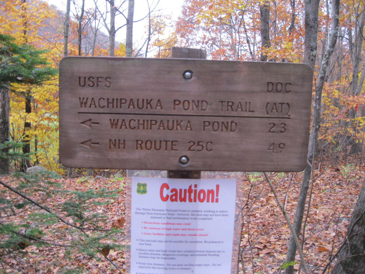 Though the foliage was well past peak, there was still some nice understory color as we climbed up the flank of Wyatt Hill.
 At the two-mile mark, we slabbed along the base of the cliffs of Webster Slide Mountain.
 We decided to climb up to Webster Slide for some views before visiting Wachipauka Pond. From the lower part of the Webster Slide Trail we could espy our objective.
 In the flat col between Webster Slide and Mt. Mist, beside a mossy stone wall, were remnants of a stove from, perhaps, an old homestead - or was it a logging camp?
 The Webster Slide Trail has one short, steep eroded section, then climbs moderately through a brushy stretch to a Dartmouth Outing Club sign near the summit.
 After a short descent, the trail emerges in a clearing where there was once a DOC shelter, and a few yards beyond that is an outlook with a startling view down to Wachipauka Pond. Thom and Dennis take in the scene.
 A true bird's eye view of the pond, with Carr Mountain in the distance.
 After enjoying this vista, we followed an unmarked 0.1 mile path down to the "Southwest View." This airy ledge perch can only be accessed by a steep, tricky down-climb (potentially dangerous for the inexperienced).
 From here you look straight down on the Webster Slide-Mist col, and out to Mt. Cube on the horizon, with part of Smarts Mountain visible on the L.
 Mt. Mist, our next objective along the AT.
Descending the Webster Slide Trail, Candace inspects what appears to be some sort of old foundation.
 Next we descended an unmarked spur trail to a clearing under a big white pine on the shore of Wachipauka Pond. This is a wonderful spot, favored by AT thru-hikers.
 Mt. Mist rises across the pond. While taking a lunch break here, we weathered a pretty heavy rain shower that lasted nearly a half-hour. So much for the forecast of partly to mostly sunny.
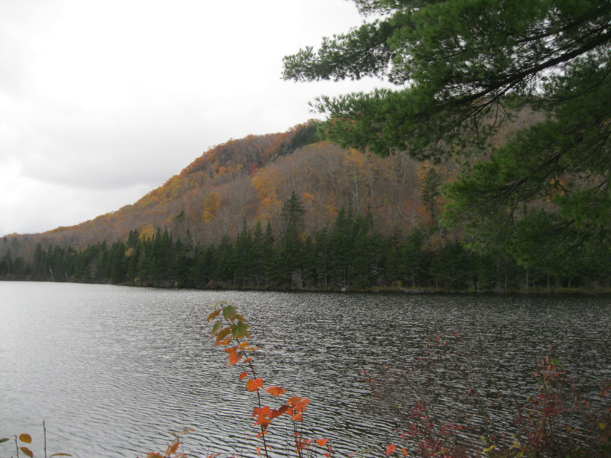 The shower persisited for a while as we headed south on the climb of Mt. Mist. Partway up I made the short side trip on a spur path to a restricted eastern viewpoint.
 With the rain stopped, we gathered for our traditional group photo at the wooded summit of Mt. Mist. L to R are Thom, Dennis, Mike, Roger, David and Candace.
 Mike was the only one of us who remembered to wear his blaze orange - moose season was underway, as well as various other hunting seasons.
 The broad crest of Mt. Mist is cloaked in a fine hardwood forest. In this section, lingering colorful beech leaves contrasted with ferns still wearing their summer green.
 Despite some muddy footing, this was a fine walk through the glowing ridgetop forest.
 This stone wall appeared beside the trail as we descended towards Route 25C.
 Next up: the Ore Hill section of the AT.
 I love the open stand of sugar maples on the top of Ore Hill. This is a great area for enriched woodland spring wildflowers such as Dutchman's Breeches and Blue Cohosh.
 The trail meanders through the open woods.
 A trailside ledge - quartzite?
 This serene little pond rests beside the trail just west of the reclaimed Ore Hill mine site (which is off limits to the public). Under various owners, this mine was in operation on and off from 1834 to 1915, producing lead, copper, zinc, and silver. Eventually the shaft was deepened to 650 feet. The haul from this mine was estimated at 50,000 to 100,000 tons. For more on the history of this operation, click here.
 After a very muddy section in conifer forest, we passed back into hardwoods on the slope of Sentinel Mountain.

We stopped for a brief break at the Ore Hill Shelter.

Descending off Sentinel Mountain, the trail led us into an enchanting spruce grove.

At Cape Moonshine Rd. (great name - a local resident says the road signs disappear regularly as souvenirs), we embarked on our final segment, Atwell Hill Trail, where super-mucky rock and log hopping alternated with pleasant leafy strolling. We all made it out with just a little daylight to spare, concluding another fine White Mountain CropWalk.

A most worthy cause + a terrific hike through some beautiful woods = a winning combination!
ReplyDeleteJohn
Thanks, John - and thank you for your generous contribution!
ReplyDeleteSteve
Love the fall foliage photos. You're lucky to live in an area with a variety of hardwood trees, and you're lucky to be able to get out on the trails and enjoy the views!
ReplyDeleteRita
http://www.onedayinameria.blogspot.com
Thank you, Rita. The hardwoods are my favorites, especially through the various stages of fall foliage. We do have a good variety of them here, and even now there's still some good color in the oaks at lower elevations.
ReplyDeleteSteve
I abosulutely love looking thorugh your pictures. I often venture in the mountains in Telluride, Colorado as well as the Catskill Mountains. Wonderful blog!!
ReplyDelete- http://jamiecarrollmusic.blogspot.com/
I agree with Steve. I love the hardwords. Lob Lolly Pines are great but they don't have the character that the big tree do.
ReplyDelete