
On a gorgeous Veteran's Day (thank you, vets, for your service) , Carol and I headed over to the Hemenway State Forest in Tamworth for a leisurely trek up through the Big Pines Natural Area to the firetower on Great Hill (1300 ft.). This mellow 2+ mile round trip brings you through a stand of ancient white pines and hemlocks with some impressively large trees, and ends up at a firetower with a magnificent view of the Sandwich Range.
On the way down Rt. 16 we had to stop for a look at the classic views from the south end of Chocorua Lake, looking towards Mt. Whiteface and Mt. Passaconaway...

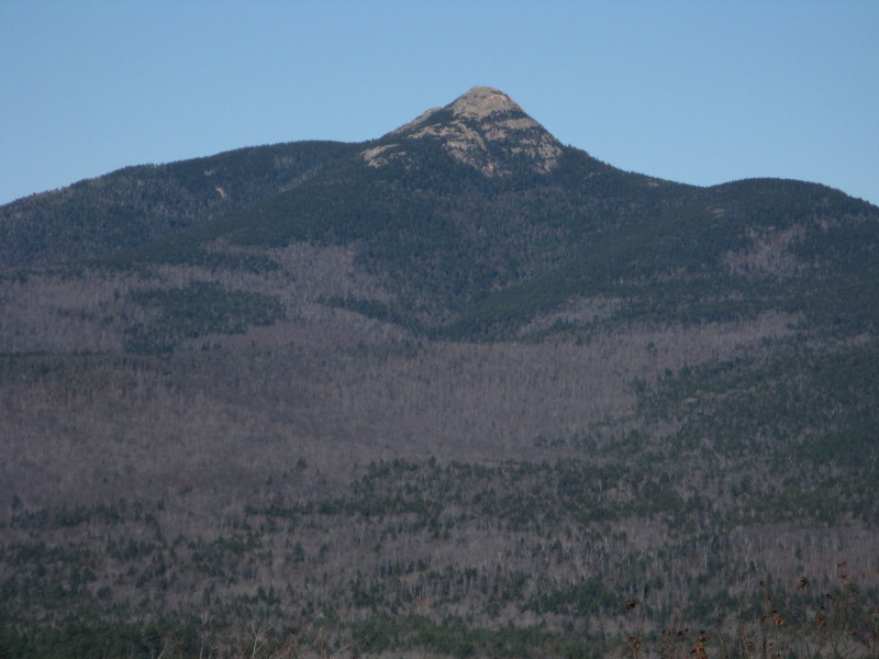
...and, of course, Mt. Chocorua.

A large sign marks the parking spot for the Big Pines Natural Area on Rt. 113A, 2.9 miles from Tamworth village.

You immediately head into the deep softwood forest.

In 0.1 mi. the trail descends to cross the Swift River on a sturdy footbridge. This bridge and the trails in this area are all the work of the Tamworth Conservation Commission. Thanks, TCC!
 Looking west up the Swift River.
A routed sign shows the trail network.

We took the R (W) fork of the Betty Steele Loop Trail, which wanders upward through those big pines.
 We believe this is the champion "Tamworth Pine," referred to in postings on the website of the Eastern Native Tree Society (ENTS). It is thought to be 150 ft. tall and has a girth of over 14 ft.!
From the upper loop junction we continued south on the newly signed Peg King Spur Trail.
 The big trees continued.
 Large hemlocks dominated from here on up, including this array of boles.
The trail passes by this mossy, tree-crowned ledge.
 A lovely stand of hemlocks on a small plateau.
 The last pitch of the trail up to the summit of Great Hill is fairly steep.
 The Great Hill tower was built in 1933 by the CCC and was taken over by the town of Tamworth in 1977. The Tamworth Conservation Commission continues to maintain it, primarily for recreational purposes. This summer a panel was affixed to the frame to provide wireless service to the town of Tamworth, but does not impede the view in any way. For more on NH firetowers, visit the website of the Forest Fire Lookout Association.
 A few years ago the Tamworth CC placed view panoramas on the four sides of the cab.
The view of the Sandwich Range from Great Hill rivals that from Mt. Israel, from a different perspective. Mt. Chocorua earns its title of "Matterhorn of the White Mountains."

 There's a head-on vista into the beautiful valley of Paugus Brook, between Mt. Chocorua and Mt. Paugus. The Bolles Trail wanders up the floor of this basin.
 Mt. Paugus displays its various ledgy lumps.
 Passaconaway (R) and Whiteface (L) are in full view, with the Wonalancet Range sweeping down in front.
 Far off to the west is the great bulk of Sandwich Dome.
 To the south is the sprawling Ossipee Range, with Whittier and Bald on the L, Mt. Shaw in the center, and the northern Black Snout on the R.
Carol scans the SE view towards Ossipee Lake and Green Mountain.

Chocorua, framed.

Heading down the stairs after a long viewing session on this crystal-clear afternoon.

On the south side of the tower there's a nice ledge to sit on in the sun, with a limited view.
 Heading back down the Peg King Spur Trail, the IPod Touch meets the big trees...
On our way home, we made a quick, easy one-mile round trip into the Bolles Preserve (owned by the Nature Conservancy) to Heron Pond. We parked at the trailhead for the Hammond Trail on Scott Rd. off Rt. 16, and followed Nature Conservancy markers across a large field in front of an old farmhouse (private property - please be respectful). On the far edge of the field a sign points L for the Heron Pond Trail, which leads through the woods, past a register, up over an esker (a small glacial ridge) and down into these nice hardwoods.

Heron Pond, also known as Lonely Lake, is a glacial kettle-hole pond with no inlet or outlet. As noted in the leaflet for the Chocorua Conservation Lands (sometimes available in the register box), the pond's "water level fluctuates in a strange manner that is not closely connected to the water table; at maximum extent it covers 8 acres, but at low levels a sand spit divides the surface into two ponds." As we approached the pond shore along a side path that ends near this gnarled old red maple, we could see that the pond level was even lower than that. The whole northern end of the pond was dry, and a large bare shoreline was exposed around the rest of the rim.
 From the end of the side path, there's a wide view of the pond. The sun is just disappearing behind the trees to the L of the low ridge known as Bickford Heights.
Here is the dried-up northern part of the pond. In a half-dozen or more visits here I've never seen the water this low.
 This is what that part of the pond looked like a few years ago in the spring.
The exposed shoreline made it possible to make my way over to the SE corner of the pond, where there is a pretty view of the Bald Mountain-Hammond Trail ridge and the cone of Chocorua rising above the pond.
 This pond inspired an entire chapter, "A Lonely Lake," in the wonderful 1893 book by the naturalist Frank Bolles, At the North of Bearcamp Water. A read of this book and a visit to Heron Pond are highly recommended. For more information on the Bolles Preserve and adjacent conservation lands, visit the websites for the NH Nature Conservancy and Chocorua Lake Association.
Hi Steve & Carol
ReplyDeleteInteresting to compare the differences in Lonely Lake now with your previous pictures.
It's kind of sad to see it like this...(after reading the book)...I'm sure it will rebound.
What great hikes thanks for the tour & the views!
Hi Tricia & Bob,
ReplyDeleteIt WAS a little sad to see the pond so low - as we approached it all we could see at first was the dry northern part. Don't know what processes are at work under there.
I'll have another Bolles-related post in a few days that you should find interesting.
Steve
Cool! I'm looking forward to it!
ReplyDelete