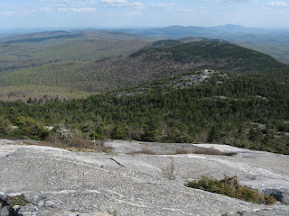
I hadn't planted my boots on the bare granite dome of Mt. Cardigan for a few years. Burned to bedrock by a forest fire in 1855, Cardigan is the iconic mountain of central New Hampshire, lording it over a vast expanse of lake-dotted hill country.
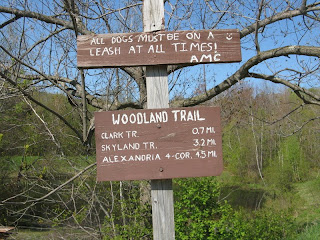
With a good forecast in hand, Wednesday seemed an ideal day to explore the less-visited ridge that extends south from Cardigan, and do some trail-checking for the AMC Southern New Hampshire Trail Guide, which covers all the Cardigan trails with an accompanying large-scale trail map. The plan was to take the reputedly obscure Woodland Trail up to the lower end of the ridge, then follow the wonderfully-named Skyland Trail to the south side of Cardigan. If time permitted, I would complete this grand tour by trekking over the summit and across to Firescrew, Cardigan's ledgy northern spur, and descending the heavily-used Manning Trail.
It's a long drive from Newfound Lake into the trailhead at AMC's Cardigan Lodge, following a succession of back roads and ending with a steep and bumpy dirt road. I parked in front of the lodge, looking spiffy after its 2005 renovation, and went inside to get some recent trail beta. The only person there was crew member Lib, and she was most helpful. For info on Cardigan Lodge, visit the AMC website at www.outdoors.org.

The Woodland Trail started right from the parking area and led me on an easy southward traverse through freshly greening hardwoods. I was pleased to find some dwarf ginseng in bloom along the way. Then the trail turned onto a grassy old logging road, which provided some very pleasant walking.


Beyond a brook the road crossed a field with an abadoned trailer. Last winter a mom and her two children took a wrong turn on a hike and ended up taking shelter in this trailer. A search was launched and this is where they were found after some anxious hours.

At 2.1 miles, after some wet footing, the old road skirted an impressive complex of beaver ponds. I took a break here on a rock seat to survey this fascinating scene. Red-winged blackbirds sang, and a great blue heron flapped by with slow, prehistoric wingbeats. Alas, the season's first swarm of black flies also made an appearance.

The beavers have fashioned quite the zig-zag dam here.

And they have felled a fair number of trees. One of their most recent breastworks has flooded the trail's crossing over the inlet brook, necessitating a short bushwhack detour to a crossing on rocks.

From here on the Woodland Trail was notably obscure, with little evident footway in places, but it was well-blazed and readily followed. Approaching the ridge, the trail was blocked by numerous fallen limbs. I pulled some off the trail, but many more await a patrol later this season by the trail crew. The Cardigan trails are maintained by professional and volunteer AMC trail crews. Spearheading the effort is the volunteer Cardigan Highlanders group.
In the open hardwood forest high up on the slope there were clusters of red trillium in bloom.

The trail topped out at a junction with the Skyland Trail near the summit of 2270-ft. Church Mountain.

I made a short side trip to the east knob of Church, where I found the outlook pretty much overgrown. This section of trail gets little use, as shown by this carpet of trout lily leaves on the footway.

Heading north towards the next summit, 2201-ft. Grafton Knob, I came across a fine display of trout lilies in bloom.

The top of Grafton Knob offered the first ridgetop view, looking south. The knob with the big ledge is Barber Mtn. Sunapee Mtn. is in the distance to the R.

Next up was Crane Mtn. (2423 ft.). From a ledge just north of the summit I got my first glimpse ahead to Mt. Cardigan and Firescrew. Ledges seen on the south shoulder of nearby Orange (Gilman) Mtn., seen on the left here, promised good vistas along the way.

The ledges on the shoulder of Orange did not disappoint. First came a big open ledge with a wide view south and west. Ragged (L) and Kearsarge (R) are on the horizon.

Five minutes farther another large slab opened a southeastern panorama. The Skyland Trail was quickly winning a new fan. What a great ridge walk - now spruce, now hardwood, now grassy ledge, and every so often an eye-popping vista.

Some more climbing led to a superb outlook near the 2684-ft. summit of Orange Mtn., hard by the junction with the Vistamont Trail. This immediately became a favorite spot, worthy of an hour's sojourn. It combined an intimate view of Cardigan and Firescrew seen across a wild valley...

...with a distant sweep north to the Whites, sprawling beyond the long ridge traversed by the Elwell Trail. Here I met the only other hiker of the day, a retired chap who was using Jeff Romano's "Best Loop Hikes" guidebook to good effect. He had come up Manning Trail and was headed down Vistamont.

A fairly steep down and the longest sustained climb of the day led on to the junction with South Ridge Trail at a place known as Rimrock. Wide views to the west here.

The South Ridge Trail was an exhilarating stroll across broad slabs, with the nearby dome of Cardigan popping into view.

An elaborate cairn/windbreak had been constructed at Cardigan's open South Peak.

From the warden's cabin the white blazes of the Clark Trail led up steep expanses of granite. I'd forgotten how exposed this dome was. Would be scary here if icy.

Higher up I got a nice look back down the ridge I had traversed on the Skyland Trail.

Soon the fire tower hove into view.

It was nearly 5 pm by the time I reached the summit, and no one else was around. I relaxed on the east side, enjoying the evening sun and the impressive view over to Firescrew, named for the towering flames seen from the lowlands during the 1855 conflagration. A few juncos were foraging among the ledges, and I got a great look at a tail-wagging American pipit, a bird that occasionally nests on the alpine tundra of the Presidentials.

The top of Cardigan is a place of vast horizons.

Some of the many inscriptions etched into the ledges are very old.

At 5:30 I headed down steep ledges on the Mowglis Trail to the broad, ledgy saddle
leading across to Firecsrew.

Heading up the easy climb on the north side, there were constant views back to Cardigan's peak.

At the summit of Firescrew I checked out a ledge with a great north view, then turned onto the Manning Trail.

The upper half-mile of the Manning Trail is one of the most scenic stretches of trail in the region, meandering across vast flat slabs with views on all sides.

A nice view north.

From the upper ledges there was a very steep and rough pitch down through the trees. Looks like the Northern Presys. This is a rugged trail!

Then the trail emerged on more ledges, with an interesting look at the Elwell Trail ridge and the valley between. These lower ledges are only about 1.7 miles up from the Lodge and would make a good objective for a shorter hike.

Once into the woods, the descent was steady, with plenty of rocks and roots, until things eased off on an old road down in the valley. Made it out by 8:00 with daylight to spare. Totals for the hike were 10.8 miles with 2550 ft. of elevation gain. A highly recommended loop!
For those interested, the bird tally for the hike was 38 species.

Steve . . . can’t say it often enough . . . your blog has provided you with a marvelous outlet to share your adventures and your knowledge with the hiking community. Your photos combined with your succinct comments are the next best thing to being there with you. They serve to take the reader along with you on your journey, and to learn a myriad of interesting things along the way.
ReplyDeleteThanks again to you and Carol for setting up this blog.
John
1HappyHiker