Saturday, May 31, 2025

Bald Peak & North Kinsman: 5/30/25


As AMC White Mountain Guide co-editor, I wanted to check out the new trailhead situation for the Mount Kinsman Trail on the west side of the mountain.  As many readers know, the trailhead that has been used since 2009 on a private land parcel has just been closed at the request of the landowner. The trailhead has been moved back to its former location at the Franconia/Easton town line on Rt. 116., next to the Tamarack Green Recreation center (formerly Tamarack Tennis Camps).  When the trailhead was located at the town line up to 2009, there was only limited parking on the shoulder of Rt. 116. That would not be adequate for the amount of usage the trail receives today. Mike Kenney, the owner of Tamarack, and owner of one side of the land that the Mount Kinsman Trail crosses for its first 1.1 mile, has built a new parking area for the trail. He will be charging a parking fee of $10 for NH residents and $20 for out-of-state hikers, with a 50% discount for veterans. When this was announced it certainly generated a lively discussion on Facebook.
 
I had spoken with Mike Kenney on the phone a week earlier, and figured I would see him at the trailhead as he lives across the street and would likely be finishing up work on the parking lot. Before setting out on my hike, I had a chance to talk with both Jeffrey Lewis, property manager for Tamarack, and Mike Kenney. Mike emphasized to me that he is approaching the trailhead access from a conservation standpoint. (He is an avid birder and naturalist, and has purchased other land in the Easton valley for conservation purposes.) He wants to keep the land open to public use, but is concerned about the heavy usage on the trail across the land that he and his brother own. I assured him that the parking fee, especially for out-of-state hikers (which I agree is too high, but he's not budging on that), would surely cut down on the usage! I am expounding on this here to suggest that there is more to this fee than a simple "money grab," as it has been portrayed on some Facebook posts. We as hikers need to keep in mind that access to trails on private land is a privilege, not an entitlement, and nearly one-third of Mount Kinsman Trail is on Kenney family land. We have the option to hike elsewhere if we don't want to pay the fee. The alternative to a fee could be to close off access to the trail. 

There is now signage at the former trailhead indicating that it has been closed.


The WMNF trail sign is now at the new parking area. There is also a hiker symbol and "Kinsman Trail" sign at the entrance on Rt. 116. The lot is accessed by a narrow gravel road that leads between two stone pillars.


The Mount Kinsman Trail begins as a woods road to the right of the trailhead kiosk.


Starting to the left of the kiosk is a new path cut by Mike Kenney, named the "Button Fern Nature Path." Mike says it's a good path for birding and nature observation as it leads through a variety of habitats. He notes that it is a "work in progress" , with further improvements needed. I headed up this way and, as expected, the first 1/4 mile was narrow and rough.


True to the name, some of the woods are quite "ferny."


The upper 1/4 mile of the path is pleasant walking on old woods roads.


The path comes out on the Mount Kinsman Trail just past the old sugarhouse.


After a long easy section the Mount Kinsman Trail makes a right turn as it enters the WMNF.


The Mount Kinsman Trail is fortunate to have Bruce Richards, one of the most dedicated trail volunteers in New Hampshire, as its longtime adopter (now a co-adopter - great to see him getting more help). A few years ago he and fellow members of the Trailwrights built this rock staircase.


I've always liked the ledgy crossing of this brook just past the site of the old Kinsman Cabin.


Nice waterbar next to an old yellow birch.


Foamflower was blooming in abundance along this section of trail.


Cascade at trail crossing of Mossy Falls Brook.


A pleasant climb through fine hardwood forest.


The spur to Bald Peak leaves at 2.1 miles, half the distance (though not half the elevation) to North Kinsman. 


This yellow-blazed 0.2 mile side path is well worth the effort.


The broad open ledges of Bald Peak (2470 ft.) are a worthy destination for a half-day hike. North Kinsman looms close by to the SE.


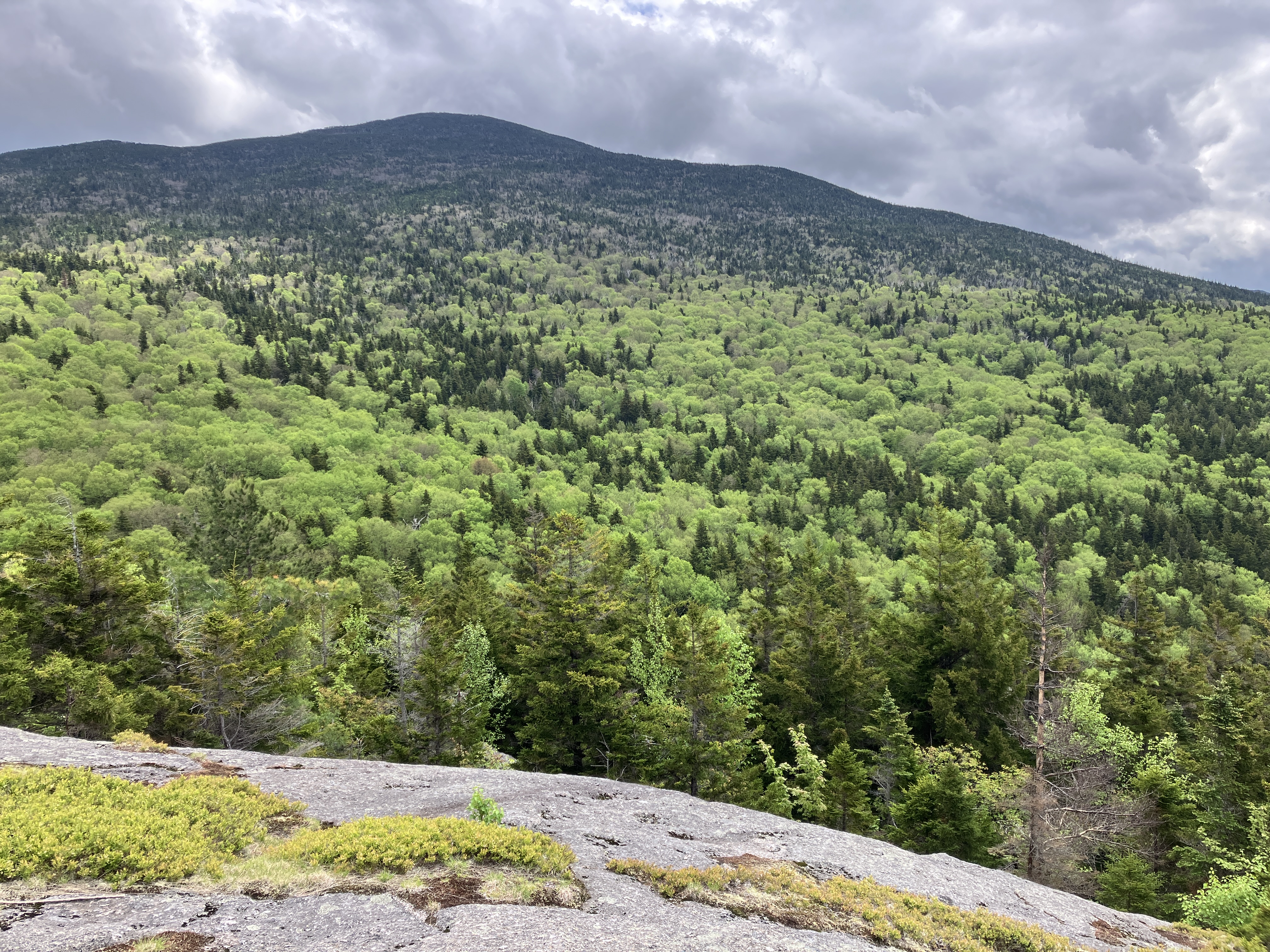
View south to Mount Moosilauke, Mount Clough and the Benton Range.


Moosilauke and Clough, zoomed. I spent an hour lounging on the ledges. No sun, but also no bugs.


I returned to the Mount Kinsman Trail and headed up towards North Kinsman, passing this patch of Painted Trilliums.


The Mount Kinsman Trail is noted for mostly moderate grades, with a few steep pitches, and even an occasional easy stretch like this.


There are rougher sections with slabs and roots.


A swath through the endless conifers.


Higher up is a relocation around a steep pitch that was abandoned. now seen as a mossy swath in the center of the photo.


Along the final angling ascent to the ridgecrest.


The Mount Kinsman Trail meets the Kinsman Ridge Trail at 3.7 miles, elevation 3850 ft.


There's a good view NE and east right by the junction.


The rough and rocky ascent (the only kind of ascent on the KRT) to North Kinsman features several scrambles up ledges, many of which always seem to be wet.


Hugging the edge here.


A scramble up to the left for this one.


Boot wedging action.


This pointy boulder is the high point of North Kinsman.


This ledge just down off the east side of the summit is one of the great viewing platforms in the Whites.


Cabot and Waumbek in the distance, Cannon and the Cannon Balls in close.


Lafayette, Lincoln and Little Haystack, of course, with Lonesome Lake nestled below.


Liberty and Flume, with Carrigain and Hancock peering over.


One of my favorite slides is tucked away in a basin between Little Haystack and Liberty.


Zoomed.


An array of southern White Mountain peaks beyond spurs of South Kinsman.


To the left of the viewing platform, a somewhat tricky scramble down a six-foot ledge provides access to...


....more great view ledges.


From here you get a fine view across to the great bulk of South Kinsman.


Best of all is the bird's eye view of Kinsman Pond, nestled at the base of the mountain's eastern cliffs.


After enjoying the summit views for an hour and a half, with nobody around, it was time to head down. I took a last look at Franconia Ridge from the Mount Kinsman Trail junction before dropping into the woods.


It was nice to be descending into the evening sun.


It was great to get back into the hardwoods after the long conifer tunnel.


This piney woods road is once again the lower part of Mount Kinsman Trail.


When I got back to the trailhead at 8:20, Mike Kenney was there, still working on the new parking lot. After a chat, it was time to head for home and a late dinner.


Thursday, May 29, 2025

Harrington Pond (Kinsman): 5/27/25

I'll introduce this lengthy report with a quote from my Ponds & Lakes of the White Mountains:  "A mile south of South Kinsman Mountain the tangled ridgecrest parts to reveal a tiny pond wrapped in a boggy mat of shrubs and sedges. Karl P. Harrington, AMC trail trail-builder extraordinaire of the early 1900s, came upon his namesake pond while laying out the rugged Kinsman Ridge Trail in 1917. Now, as then, this little lakelet enjoys a picturesque setting amidst ragged ledges and twisted firs."
 
I hadn't been to remote and beautiful Harrington Pond since 2016, and with short relocations planned in the next year or so by the WMNF on the Reel Brook Trail  and on the Kinsman Ridge Trail at the pond, it was time for a re-visit. Additional attractions for the hike would be enjoying the many cascades on Eliza Brook with a good flow of water, and seeking a unique view over the pond from the well-guarded cliffs on its north side.
 
The "official" parking area for Reel Brook Trail along the narrow, gravel Reel Brook Road is quite rough and rocky. A recent report that it had been greatly improved was not accurate. As usual, I parked in a smooth, level pulloff on the right, 0.2 mile back down the road (0.4 mile in from NH 116).


The lower two miles of Reel Brook Trail is mostly mellow and pleasant walking, with a few brook crossings mixed in. The volunteer adopter keeps this trail in tip-top shape.


At 1.4 miles the trail makes a powerline crossing where the footing is soggy. The grass was low this early in the season, but ticks are always a concern in these brushy places.


Beyond the powerline, there's a lovely trailside pool and cascade on Reel Brook.


There's an inviting broad ledge at the top of the cascade.


The planned relocation will bypass the first two of three closely-spaced crossings of Reel Brook. This is the third crossing.


As the trail climbs steadily away from the brook, there are several long sections with wet and rocky footing. In the past this old road was apparently bulldozed periodically to provide vehicle access to the powerline, and it has never recovered.


The upper section of Reel Brook Trail has easier grades along the broad ridgecrest. Here I saw perhaps the last Trout Lilies of the season.


On to the Kinsman Ridge Trail/Appalachian Trail.


The next half-mile is a series of meandering ups and downs through mossy conifer forest.


The trail re-crosses the powerline in the col between Mount Wolf and South Kinsman - the "original" Kinsman Notch.  It's believed that Nathan Kinsman, the first settler in the town of Easton, may have come through this notch on the way to establishing his family homestead in 1782.


Cliffs on the north side of the notch.


Though compromised by the powerline, there are views to the SE here towards Mount Osceola, Scar Ridge, Loon Mountain, Sandwich Dome and Bog Pond. Eversource, the power company, is proposing to rebuild this transmission line in the near future, replacing the wooden poles with steel poles that will be 15 feet taller.  This will require significant construction activity, including this spot on the AT. There will be much helicopter action. Project details are here: https://www.fs.usda.gov/r09/whitemountain/projects/67011. This project has been granted a "categorical exclusion" by the USFS, which means no Environmental Assessment is required, and thus no public comment. According to the document, work is slated to begin this September.


Zoom on the west half of Bog Pond. Before the powerline was built in the 1950s, this high, remote plateau must have been one of the wildest areas in the Whites. 


Beyond the powerline, the Kinsman Ridge Trail descends moderately into the Eliza Brook drainage.


There's a real sense of remoteness out here.
,


Eliza Brook Shelter, rebuilt by AMC in 2010, is in fine shape in its wonderfully secluded location.


There are four tent pads in addition to the shelter.


The trail crosses Eliza Brook by the shelter.


For 0.3 mile beyond the crossing, the trail follows an old logging road at a nice grade.


Then the trail drops down to follow the brook with occasional deviations away from it. It soon passes the first of multiple attractive cascades. My last trip through here was during a dry August with meager flow. The cascades were on full display on this day.


There are a few short rugged stretches along this section.


The cascade and pool theme is repeated often.


Were it closer to the road, this section of trail would be quite popular. Being 4 1/2 miles in, the cascades are less often visited except by thru-hikers, other backpackers, and peakbaggers doing the south to north traverse of the Kinsmans.


They keep on coming.


A strong flow here.


Nearly a sheer drop on this one.


Looking down at a flume-like formation.


Farther up the valley, the brook and trail level off, and the trail then crosses the stream to ascend steeply to Harrington Pond.


Recent bridging installed by the AMC trail crew.


The ascent to the pond is quite steep and rugged for a spell.


Mossy fir woods on the approach to the pond.


A hogback ledge.


A rocky portal at the top of the climb.


After tramping through the woods for 5 1/2 miles, it's exhilarating to break into the open atop this plateau at 3,390 ft., on a sunny day with puffy cumulus clouds.


The small open water area of the pond is surrounded by an extensive mat of bog vegetation. Many pitcher plants bloom out there in the summer. In his 1926 book, Walks & Climbs in the White Mountains, trail-builder Karl P. Harrington wrote, "It was to this little Harrington Pond that a frog piping his nightly serenade guided the writer through the dense darkness, when first a trail was roughly blazed along this hitherto inaccessible ridge."


Plank walkways protect the fragile vegetation and keep hikers' feet dry. However, at times the walkways are partly underwater, and the WMNF plans to re-route the trail through the woods to the east of the pond. Seen here is the high, scrubby, ledge-dotted ridge of South Kinsman rising towards the summit. The mile-long climb from here is very steep and rocky, noted as one of the most rugged sections of the AT in the Whites. There are fine views from ledges in the upper part.


One of my potential objectives for the day was to try and access a view over the pond from one of the cliffs along its north side. I knew the whacking would be thick and gnarly, and if I heard any calls or songs from a Bicknell's Thrush - an elusive and rare species that specializes in these dense subalpine forests - I would forego the mission so as not to disturb nesting activity.


All was quiet around the pond, so I headed into the thick of it.


This part was not going well.


I think I need to get up there.


It looks like there's a cliff down there.


There is, but there's no safe way to get out on it.


But with a bit of thrashing through the cripplebrush (an Adirondack term), I was able to obtain a standing view over the pond. It was worth the effort! Mount Wolf rises behind the next hump on the ridge, and Mount Moosilauke is seen to the right.


A nice distant view to the SE.


I took a half-hour break at a comfortable spot with a screened view through the trees. Thankfully, the bugs were on hiatus this day.


It was late in the afternoon, and I had a long hike out, but I wanted to see if I could get to the top of the larger cliffs just to the west. From my resting spot, I climbed steeply....


...to a small wooded plateau between cliff bands.


The next set of cliffs rose impressively above.


I worked my way back to the south towards the cliffs above the pond, and caught a view of the long, massive SE ridge of South Kinsman.


Through the cripplebrush I spotted a small ledge perch below, seen in the center of the photo.


This looked promising, though not easy to get to.


Wow!


Moosilauke again.


An expanded view to the SE.


Chocorua, Kancamagus, Passaconaway, Osceolas, Scar Ridge, Loon and Tecumseh.


The biggest cliff overlooking the pond drops off sharply close by to the right.


It's 5:00 pm - I need to get out of here and back to the trail!


I found a much better return route and got back to the trail at 5:30 after a three-hour wander.


Back at Harrington Pond, I could look up at the cliffs and spot the little perch I had reached, at top center of the photo.


Parting shot.


A possible spot for the relocation around the pond.


Steep descent from the pond.


A mellow section of trail along Eliza Brook.


I missed this cascade on the way up.


Evening sun on Bog Pond.


Walking into the sunset on Reel Brook Trail.


Woodsy alpenglow.


Old yellow birch.


Powerline and Cole Hill at dusk. Did the last easy 1.5 miles by headlamp.