I spent a golden early October day making a leisurely exploration of the 1954-vintage slide on the east face of Flat Top Mountain (3248 ft.), a wild northeastern spur of Mount Garfield. The Canadian wildfire smoke haze had moved out of the Whites, ushering in clear air for foliage viewing. The slide, and the ragged cliffs that loom above it, are seen in this Google Earth image.
The full length of the slide, which drops nearly 600 ft. in elevation to the brook known as Garfield Stream, is visible in this winter photo taken from North Twin Mountain in 2009. The large opening in the middle is an area of steep gravel banks. When this slide came crashing down during Hurricane Carol in 1954, it was wider and had two additional prongs, one each to the left (south) and the right (north) of the central track seen here. The left prong is completely revegetated. Only one small open patch remains on the right prong.
The long, gentle hardwood approach on the Gale River Trail is a pleasure to walk during foliage season.
Color both overhead and in the understory.
Window view of a stair-like formation on a spur of North Twin.
After crossing Garfield Stream, I headed off-trail up the valley of that tributary, which flows off the NE side of Mount Garfield. This valley was the original route of the Gale River Trail, up past
Hawthorne Falls to the Garfield Ridge Trail in the col east of Mt.
Garfield. (The trail to Galehead Hut was then called the Galehead
Trail.) This trail section was abandoned in the late 1950s. A few parts
of the old footway are still evident to the practiced eye, while most sections have been fully swallowed by the forest.
Partway up the valley I dropped down to this cascade, which was first described in July 1880 by Benjamin A. MacDonald, who penned a series of hike descriptions entitled "Echo Explorations" in The White Mountain Echo, a leading tourism newspaper published in Bethlehem, NH. As part of a multi-day exploration in the Garfield area, MacDonald and notable local guide Allen Thompson bushwhacked up the Garfield Stream valley, camping along the way. They agreed to name this cascade "Eaton Falls" after a local farmer named Eaton, who they had encountered en route to the Gale River valley. The entire run of The White Mountain Echo has been digitized and is available on the website of the Bethlehem Public Library: http://bethlehem.advantage-preservation.com/
An interesting arc of rocks holds in the pool at the base of the cascade.
Above the main waterfall is a broad sheet of granite that ends in another cascade.
On several previous visits here, there was usually enough dry ledge to walk around on a bit. After our rainy summer the big slab was soaking wet and slick as ice.
As Benjamin MacDonald wrote in his "Echo Exploration," a careless step here "and away you go, down, down two hundred feet into eternity."
Now that's a serious blowdown!
Looking downstream from the top of the big slab, with a glimpse of the Pilot Range in the distance.
I crossed the stream at this convenient spot, but even here you had to step with care as the ledges were damp and slippery.
I soon picked up the brushy track at the base of the slide.
A section grown to small spruces.
A small exposed ledge step.
From previous visits I knew the next part of the track was a steep, narrow gully with slippery footing, so I headed up into the woods to bypass it.
Steep climbing on this slope, but the forest wasn't too thick.
Emerging at the big open gravel area halfway up the slide.
This sharp gravel spine is an unusual feature of the Flat Top Slide. It is bordered by gullies on either side.
From here there's a marvelous view across the Gale River valley to North and South Twin, looking quite massive from this angle.
Looking up the spine to the Flat Top cliffs.
Closer look. There are some great perches up there, but they are not easy to get to. The one time I went up to the ledges I made a long flanking maneuver to the north to get around the cliffs.
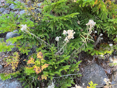
Pearly Everlasting, one of the most common slide colonizers.
After a long lunch break, I headed up the slide track from the top of the open gravel area towards the open patch at the upper end of the slide, about 300 feet in elevation above here.
The track was rocky and narrow, a bit overgrown in places, but easy to follow.
Onward and upward.
The upper end in sight above.
Rugged terrain up here.
A wild scene approaching the top of the slide.
This part was too steep and sketchy to ascend, so I climbed alongside it.
Looking down from the top.
Dead end ahead.
Expanded view of North Twin from this higher perspective.
Slide meets cliffs. A rugged mountain!
Descending the steep woods alongside the slide. Slow going, but better than the loose and slippery rocks of the track.
A patch of Whorled Wood Aster has reclaimed a part of the track.
A few scraggly blossoms hanging on.
Back down to the gravel spine for another prolonged break.
Fire on the mountain.
A spur of Garfield Ridge.
From the gravel area I whacked north across the slope to the lone remaining open patch on the northern prong of the slide.
A better perspective here on the headwall of the Gale River valley. Look closely and you can see the dark stripe of a slide that fell during the September 1938 hurricane.
North Twin, framed.
Cliffs and fir waves on a shoulder of North Twin.
Garfield Stream.
Evening on the Gale River Trail.


The true wanderer goeth alone. And, wow, this wanderer observes with such grace and care.
ReplyDelete