A gorgeous end-of-summer day found me wandering into one of my favorite locales in the Presidentials - the wild, less-visited glacial cirque known as Castle Ravine, enclosed by Mt. Jefferson's Castellated Ridge and the Israel Ridge of Mt. Adams. On the way in I followed the Israel Ridge Path to the First and Second Cascades on Cascade Brook, then took The Link across to Castle Ravine Trail and headed into the upper ravine and climbed to the first open rock area on the headwall for excellent views. The day also included short bushwhacks to two slides in the ravine, both of which proved to be overgrown but still provided interesting views.
After an easy 1.3 mile approach on the Castle Trail that included a fairly tame crossing of the Israel River, I turned left onto the Israel Ridge Path, one of the many trails on the Northern Presidentials admirably maintained by the Randolph Mountain Club.
After another crossing of the Israel River, the trail follows alongside it with some nice water scenery.
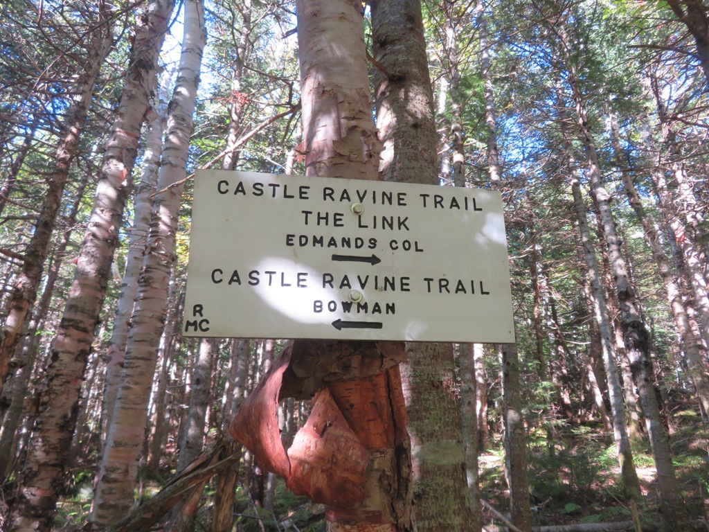
After a long sidehill climb I reached the first of two junctions with The Link.
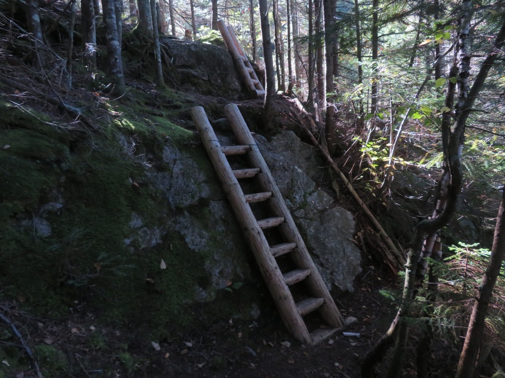
I continued a short way up Israel Ridge Path to the scenic Second Cascade. Just before reaching the cascade, the trail mounts ledges by a pair of ladders.
The broad ledges of Second Cascade look up at nearby Mt. Bowman, a spur of Mt. Jefferson.
Second Cascade, from the bottom of the ledges.
I backtracked down to The Link and followed it a short distance down to a flat ledge at the top of First Cascade, another fine spot.
The first part of The Link heading towards Castle Ravine lived up to its gnarly reputation, contouring roughly on a steep sidehill. Then there was a long section of pleasant walking through open salt-and-pepper woods of birch and fir. Very un-Link-like.
The wild and beautiful Castle Ravine Trail was completed around 1919 by the Randolph Mountain Club.
The trail meanders up the remote valley of Castle Brook, an inner sanctum of the Northern Peaks.
High in the valley there are several crossings of Castle Brook, which had a surprisingly strong flow in a dry season. The crossing shown here is unusual in that you actually walk up the brook for about 30 yards, angling to the other side - note the RMC "Path" sign on a thin tree at the top of the photo.
Then you cross back to the other side to another "Path" sign.
Not much farther along there are two more crossings in a location where an avalanche swept through in the winter of 2010. Some of the debris, now well-settled down, is still in the brookbed.
This is the brookbed in 2011, a year after the avalanche.
This is the current view looking up the avalanche track from the second crossing.
From both crossings there is a nifty view up to the Castles on the Castellated Ridge.
Just past the second crossing the trail passes through an area of large rocks where you can hear water rushing underneath.
From here a short bushwhack brought me to the track of a long, narrow slide that fell on the south wall of the ravine during Tropical Storm Irene in 2011.
In 2014 the slide looked pretty open when seen across the ravine from Emerald Bluff.
But in the intervening years scrubby birches had reclaimed much of the track.
Climbing this was slow going as the rocks were treacherously wet and slick. I turned back after gaining about 150 ft. of elevation.
One big dry rock in the track provided a good view to the NW.
Zoom on Starr King and Waumbek. I could study the slab on the Waumbek Slide I'd dropped down to the week before.
Emerald Bluff, the great viewpoint on the other side of the ravine.
After carefully descending back to the trail, I continued up towards the headwall. The squeeze through this crevice leads in a few yards to...
...Roof Rock, one of the cool features of Castle Ravine Trail.
Some steep and rough climbing led to a big open patch of rocks on the lower part of the headwall. I was surprised by the difficulty of a boulder scramble where you first emerge from the scrub. I didn't remember it being that hard 10 years ago...
The RMC has placed a helpful arrow for descending hikers. In general, though, descent of this trail is not recommended as there is much loose rock on the steep headwall.
I love the vista back down the Castle Brook valley and out to distant summits including the Jay Peaks and Mt. Mansfield.
This is a rugged section of trail.
Looking up towards the top of the headwall.
Orange blazes show the way. Below the headwall, the trail is blazed in yellow.
Looking across at the crags on the south wall.
Castellated Ridge, "the sharpest and most salient of the White Mountain ridges" -- a long-standing quote from the AMC White Mountain Guide.
The trail exits this rock patch for a rough traverse through scrub, then re-emerges for a long, steep climb up loose talus. This was my turnaround point today.
Rugged scenery.
Shadows creeping into the valley.
A wild jutting crag on the north wall.
Descending through the jumble of rocks - slow going.
Last look at the headwall - some nice early birch color.
On the return trip along Castle Ravine Trail, I bushwhacked down across Castle Brook and up to a double slide on the west side that I had visited twice previously and where I had found a good view up to the ravine headwall. This slide looks fresh in a 1999 aerial photo, so it may have fallen during the 1995 storm that triggered the Dogleg Slide on Mt. Osceola and the north slide on North Twin. Since my last visit in 2009, the slide has grown up considerably.
There's still a nice view out to the Weeks peaks and Mt. Waumbek's long east ridge.
The view of the headwall has become restricted, but is still interesting.
The scrub alder and conifer growth around the two parts of this slide was a force to be reckoned with, reducing me to a literal crawl in one spot. I made it back across the valley and followed Castle Ravine Trail down through four more brook crossings - the lowest two are difficult due to awkward footing on pointy, slippery rocks - and did the last 20 minutes out by headlamp. Didn't see another hiker the whole day.


LOL at "Very un-Link-like." I hear ya. Also, good description of the part where the trail literally goes along a section of the brook; I distinctly remember that RMC "path" sign.
ReplyDeleteHi Ben, The Link definitely is a Jekyll-and-Hyde trail. Lots of water on Castle Ravine Trail!
Delete