On a fine sunny day I took a stroll up Livermore Trail to the NW side of Mt. Tripyramid, then bushwhacked up the floor of the tributary valley of Avalanche Ravine, which parallels the route of the Scaur Ridge Trail. It's a lovely sunny, open drainage with many old yellow birches overlooking the stream. After taking in the views from a glade on the north side of Scaur Ridge, I descended the always-pleasant Scaur Ridge Trail with its impressive views of Tripyramid's North Slide.
White Cascade on Slide Brook was roaring after heavy rain earlier in the week.
Bare trees and blue sky beckon a hiker onward along Livermore Trail.
A bushwhack alongside Avalanche Brook brought me into the tributary valley. I would follow this stream for ~0.6 mile with an ascent of 600 ft.
A magnificent old leaning yellow birch.
Island in the stream. This brook has no name, and doesn't even get a blue line on the current 7 1/2' USGS Mount Tripyramid quad. It does show up on the old 15' USGS Mount Chocorua quad.
Open corridor.
Guardians.
Triple-trunk.
A picturesque drainage.
The banks close in.
Final approach to where the Scaur Ridge Trail crosses the brook at 3100 ft. Plenty o' hobblebush here.
Junction on Scaur Ridge.
Mt. Washington seen from an open glade on the north side of Pine Bend Brook Trail.
Mts. Carrigain, Willey and Lowell.
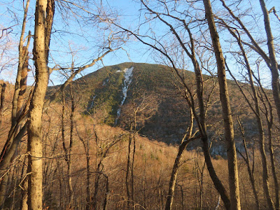
One of the joys of the Scaur Ridge Trail after leaf-fall is the shifting view of North Tripyramid and its great North Slide.
Diminished in size but still impressive 135 years after it came crashing down during a massive rainstorm.
Zoom on the wide top of the slide, a notable viewpoint.
Smooth sailing on the Scaur Ridge Trail.
A fitting entrance to the Sandwich Range Wilderness.
Late afternoon on the Livermore Trail.


No comments:
Post a Comment