Every couple of years I'm drawn to spend a day exploring in the glacial
cirque known as The Bowl, an inner sanctum of the Sandwich Range encircled by Mt. Whiteface, Mt. Passaconaway and the. Wonalancet Range. There are no signs of this valley ever having been
logged (more specifically, the main or west branch of the Wonalancet River, aka Wonalancet Brook;
the valley of the east branch did see some early logging). It was saved
from lumbering about 1915 through the efforts of Katherine Sleeper, Edgar Rich and
other members of the Wonalancet Out Door Club. The land was then added
to the White Mountain National Forest, and in 1931 much of the western
valley was designated as a 510-acre Natural Area. More recently what is now called The Bowl Research Natural Area was expanded to
over 1500 acres, including the entire drainage of the Wonalancet River. (Please note that camping and fires are not allowed in The Bowl Research Natural Area.)
Scientists have conducted many studies on the ecology of The Bowl over the years. An interesting publication is Botanical Reconnaissance of The Bowl Research Natural Area, by
Lee E. Carbonneau and Sarah D. Allen (1995). To get deep into The Bowl,
bushwhacking is required. The Bowl features perhaps the most extensive stand of
old-growth hardwood in the Whites on its broad floor. On trail, samples of the magnificent hardwood
forest can be seen on the lower Tom Wiggin Trail and the middle
of Dicey's Mill Trail. Most of the old-growth spruce and fir on the walls of the cirque were
destroyed by hurricanes and other natural catastrophes.
There are several fine views down into The Bowl
from
outlooks on the Blueberry Ledge Trail and Rollins Trail. In early October, the hardwood forests of The Bowl were at near-peak color as seen from the Blueberry Ledge Trail. Mt. Passaconaway rises beyond the ledge-scarred headwall.
A good place to spend the day.
The Wonalancet River valley offers some of the best hardwood forest walking in the Whites, especially nice in late fall with bare ground and bare trees.
Easy walkin' on Dicey's Mill Trail, the oldest route up Mt. Passaconaway. It was opened in 1891 by AMC luminary Charles E. Fay with the help of local residents.
A couple miles in I left the trail and crossed the east branch of the Wonalancet River, once known as Passaconaway Brook.
I've been into The Bowl a half-dozen times over the years, never by the exact same route, and each visit brings new sights to light.
A large old yellow birch.
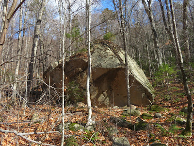
Neat rock.
One of several fine stands of mature sugar maples. Some of these trees may be 250 years old. I tread lightly and respectfully on this sacred ground of the Sandwich Range.
Looking northwest, the long north ridge of Mt. Whiteface is seen through the trees.
Peaceful scene along the Wonalancet River.
And another.
The lower track of a slide that scars the north ridge of Whiteface, which forms the western wall of The Bowl.
Up close, its girth is impressive.
Following the blue line on the map.
A fallen giant.
The hardwoods go ever on in the valley.
More large maples on the broad floor, deep in the valley.
Following a dry brookbed/slide track to a small slide on the Bowl's headwall.
The headwall looms behind Catskill-like open hardwoods.
Overhang.
The hardwoods march far up the headwall.
Approaching the slide, which I first visited in the winter of 2007.
Pretty scene.
The south-facing slide enjoyed plenty of sun on this chilly late fall day.
A cascade spills into an unusual circular ledge sculpture.
Top-to-bottom view.
In winter the slide is more visible from afar, as seen in this view from a ledge slab on the sidewall of The Bowl.
After a long break at the base of the slide, I climbed very steeply though the woods along its left side.
In winter I was able to snowshoe out onto this slab for a view of Mt. Whiteface, but without the snow cover it would be dangerously slick.
Continuing up along the slide above the big slab.
A headwall leaner.
Looking west across the headwall to high, steep slabs.
An attractive little cascade higher up on the slide.
A backlit silhouette of Mt. Whiteface. I was now a couple hundred feet in elevation above the base of the slide. I decided - after leaving a message for my wife about this change in plans - to continue whacking all the way up the Bowl headwall to the Rollins Trail.
My route was through the light green growth to the right of the big slab and thin crease marking the slide, as seen in this view from another slide on the NE ridge of Mt. Whiteface taken during a previous excursion into The Bowl.
It was steep, but the woods were reasonably open for much of the ascent.
Getting scrubbier.
In the upper part things got a little ugly.
Happy to reach the Rollins Trail at 3300 ft. in the broad saddle between Whiteface and Passaconaway.
An important junction for those doing the Whiteface/Passaconaway loop.
Dicey's Mill Trail is as pleasant a descent as you can find on a 4000-footer. In places it displays excellent rock step work by the Wonalancet Out Door Club.
Late afternoon sun on Nanamocomuck Peak (L) and Wonalancet Hedgehog (R). From 1916 into the 1940s, a WODC trail called Walden Cut-Off climbed from Dicey's Mill Trail up the eastern valley of The Bowl (the drainage of Passaconaway Brook) to the Walden Trail in the deep notch seen in this photo. It was abandoned during World War II.


Excellent adventure, Steve! Looks like a nice place to explore.
ReplyDelete