
MOUNT OSCEOLA: 6/6/16
This day looked like the pick of the week, so I opted for a moderate afternoon/evening hike from Tripoli Road so I could enjoy the views from this old favorite for a long time.
Some cribbing work at the start of the trail.

This rocky little stream was in good flow after a heavy rain the previous day & night.

Those familiar with the Mount Osceola Trail know that the lower third is a rockfest worthy of Woodstock.

More rocks.

And still more.

There is one smooth gravelly section in the middle of the climb.

A welcome break from the rock-hopping.

Extensive erosion control work was done on the trail in 2015. The lower section was worked on by the WMNF Pemi District trail crew. The upper half was handled by the AMC trail crew, with the support of a $5,000 donation from the AMC Four Thousand Footer Club. Thanks to all who made contributions!


This rock waterbar was built to last.

The AMC crew built this little staircase at a spot where there was a potentially dangerous eroding scramble along a side-sloping ledge.

More good work.

The familiar sloping slabs on the upper switchbacks. These are often icy in late fall and spring.

This SW view over Breadtray Ridge along one of the switchbacks has opened up in recent years.

A hazy look at Mt. Moosilauke.

The western Pemi Wilderness from the north view ledge, reached by a side path at the true summit, where the first fire tower was located.

North to Mount Washington.

The scrub has grown up around the north view ledge, so now you have to stand to see the view.

On to the expansive main ledge with its classic view east over the Osceola Brook ravine to the Sandwich Range.

The high peaks of the Sandwich Range, with remote Lost Pass on the right.

The Tripyramids, with the North Slide prominently displayed.

Clouds and shadows made for dramatic views, especially looking across towards East Osceola.
Sandwich Dome beyond Waterville Valley.


The summit benchmark.

There is also a reference marker pointing to the summit benchmark.

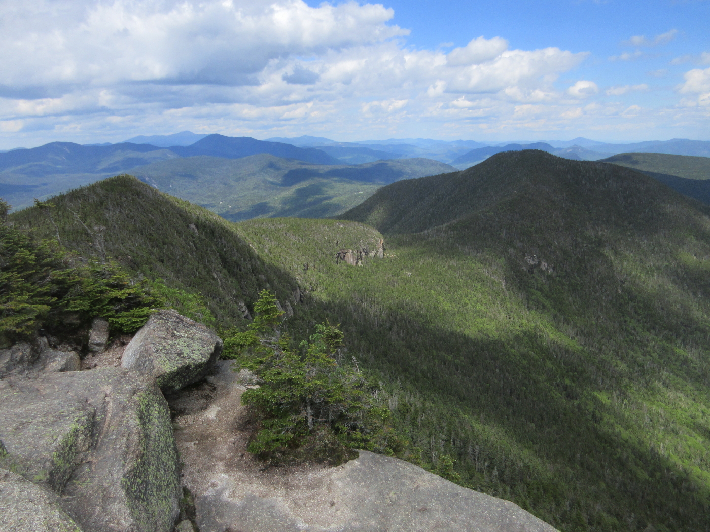
A short distance down the trail towards East Osceola I found this peek at Middle Osceola and the tip of West Osceola...

.....and this Pemi vista.

I had the summit to myself for most of 2 1/2 hours - an advantage of starting out later in the day.

The mighty Carrigain and its trailing Signal Ridge.

Late afternoon light.

It was hard to leave.

This northern view was obtained via a very short bushwhack from the trail.

A sunspotted vista west to Middle Osceola and beyond.

The beaver pond on Cheney Brook can be seen at the lower left.

Evening glow on the slope above the parking lot.

"It was hard to leave"--killer photo!!
ReplyDeleteThanks, Steve - love that late afternoon light!
DeleteSteve
Thanks for posting. A fantastic set of pictures.
ReplyDeleteGreat photos! I thoroughly enjoy your blog. So many great ideas for hikes. My girlfriend's son and I are looking for a hike on Monday, on the last day of my vacation and this one will now be near the top of the list :-)
ReplyDeleteThank you, Don - glad you enjoy the reports. Monday looks like a great day!
DeleteSteve