
THE QUIET SIDE OF MOUNT MOOSILAUKE: 9/4/13
With sunny skies and low humidity predicted for Wednesday, a visit to Mount Moosilauke, an all-time favorite, was in order. I hadn't been up the Benton Trail - the quiet, scenic and moderately graded northwestern approach - in a few years. I was also curious to see the Irene damage on the now permanently closed Tunnel Brook Road, and I hoped to find an off-trail view of Tunnel Ravine to gawk at a huge slide that was triggered there by Irene.
Some of the worst damage on the road is just beyond the gate at the road junction 1.4 mi. in from Rt. 112, where hikers must now park.

More Irene damage, with a well-beaten path skirting it on the R.

The road walk is 1.5 mi. to the start of the Benton Trail.

The crossing of Tunnel Brook can be tough in high water. Not bad today.

After crossing a logging road, the lower part of the Benton Trail ascends through fine hardwood forest. This section will have a different look after "single tree selection" logging is done on both sides of the trail up to ca. 2300 ft. in the upcoming "Pemi NW" timber harvest by the Forest Service.

At 1.3 mi. and 2730 ft. is the fine Little Tunnel Ravine outlook, a great spot for a break.

The Kinsmans rise impressively off to the north.

A thousand feet higher up along the trail is a spring that was mostly dried up on this late summer day.

I left the trail and bushwhacked west across the slope, seeking one of the open fir waves I had visited on a bushwhack in 2008; several of these fir waves offered great views into Tunnel (Benton) Ravine. The woods were nice and open much of the way across the slope.

Behind one of the fir waves was a neat open area of ferns.

It took a while to get down to the front of a more open fir wave, where the new growth springing up under the dead, bleached trunks was low enough to permit open views. This spot had a fine perspective on Mt. Clough, with its several slides plunging into Tunnel Brook Notch.

Most of these slides reportedly fell during a great storm in November 1927.

I wanted to have a look at a major slide that fell into Moosilauke's Tunnel (Benton) Ravine during Tropical Storm Irene. My bushwhacking friend J.R. Stockwell has ascended this slide en route to the summit of Moosilauke, and I found a blog report on another ascent of this slide just this summer.

This is what the ravine headwall looked like on my previous bushwhack to the fir waves in 2008.

The 2011 slide is a pretty impressive addition to the scenery of the ravine!

A zoom on the bottom part of the slide. Back in 1995 I visited an older slide on the other wall of the ravine, a bit farther down the valley. Would like to go back in there and see this new one close up.

After enjoying a leisurely lunch break at the fir wave, I whacked up the ridge, following a moose path at one point.

There was some nice old ferny balsam fir forest on this ridge.

Back on the Benton Trail, a beautiful easy mossy section at 4100 ft.

What a nice route up the Moose!

At 4400 ft. there's a fine little outlook to the west, reached by a short side path. Black Mountain is seen here beyond Long Pond.

I didn't see anyone along the Benton Trail, and just one hiker descending above the Beaver Brook Trail junction, bundled up in fleece because of a chilly wind above treeline. Clouds had also moved in, earlier than predicted, dropping the temperature a bit.

I love the view of ridge after ridge from the north end of Moosilauke's summit ridge.

The summit rocks in sight ahead. Two hikers were leaving, and there was only one other person there.

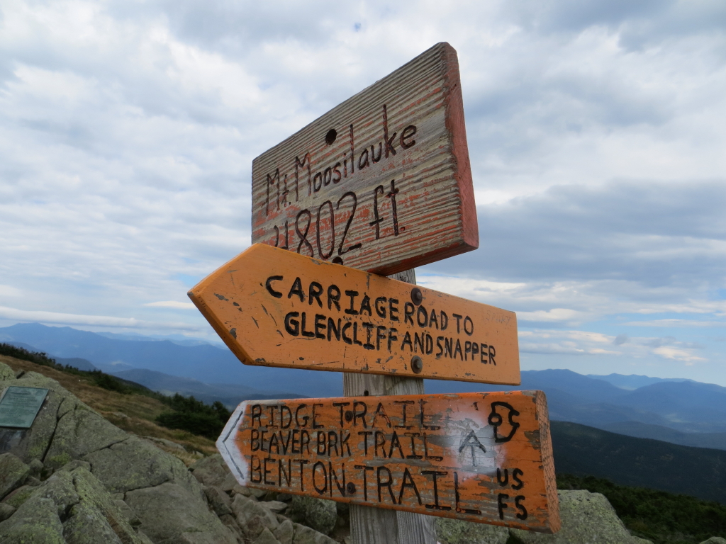
Classic orange DOC trail signs at the summit.
Looking east across the broad, rounded East Peak of Moosilauke.

US Coast & Geodetic Survey benchmark near the summit.

It was clear enough to see several Adirondack High Peaks (Dix, Haystack, Marcy, Gothics, Algonquin, Rocky Peak, Giant and Whiteface) when I arrived, but then dark clouds started gathering in the west, decreasing the visibility.

Clouds moving in over the high peaks of the Whites.

Hanging out on one of my all-time favorite summits. It was chilly in the wind; I used the wool shirt, fleece and hat in my pack for the first time since May or June.

Looking up the broad-backed north ridge.

Looking south across the summit rocks.

After a two-hour summit stay, I enjoyed a breezy stroll back across the north ridge. The tawny sedges were rippling in the west wind.

I enjoyed the last sun of the day here before the clouds rolled in for the evening. The triple-peaked ridge on the R is the crest that runs north from Mt. Blue. J.R. Stockwell has bushwhacked this ridge.

Last look back before dropping into the trees.

Beautiful stretch on a high shoulder of the mountain.

Looking into Little Tunnel Ravine on a grey evening, last view of another great day
on the Moose.

Terrific photo-documentation comparing the ravine headwall as it appeared in 2008 vs. its appearance following the 2011 slide.
ReplyDeleteExcellent photos of the summit area of Moosilauke. It's such a unique mountain among the NH48. When driving up I-91 in VT yesterday, I could glance over and see a thin sliver of the tawny-coloration at the top of the mountain.
John
Thanks, John - that slide certainly had an impact on the ravine. Would be fun to check it out sometime, as well as the older slide on the other side. Unfortunately the approach is a lot longer now with the road closed.
DeleteSteve