
In keeping with a recent theme of long treks through remote Wilderness valleys, I headed over to the Wild River Valley, one of my favorite places in the White Mountains. This broad basin between the Carter-Moriah and Baldface-Royce Ranges shares many characteristics with the Pemigewasset Wilderness, though it is smaller and much less visited. The picture below, taken by my wife, Carol, from Mt. Hight, shows part of this expansive and beautiful area.
 I made the long drive over to Gilead, ME and then down Rt. 113 and the gravel, 5.7 mile long Wild River Rd. to the hiker parking area at the end by the Wild River Campground. As I was getting my pack ready, I chatted with a three-person Student Conservation Association crew that was going out to check and rehab bootleg campsites along the Wild River Trail. One of their next jobs would be to dismantle the Perkins Notch Shelter - my turnaround point for this hike - and construct three tent pads nearby.
 The Wild River Trail makes a detour through the woods around the campground, then picks up the grade of the 1890s vintage Wild River logging railroad. Shortly after passing the Moriah Brook Trail junction, you enter the Wilderness.
 The railroad grade, as you would expect, offers an easy-graded walk, though there are quite a few washed out stretches with loose, stony footing.
 About 2 1/2 miles in, I followed a side path down to a fine ledgy area on the Wild River.
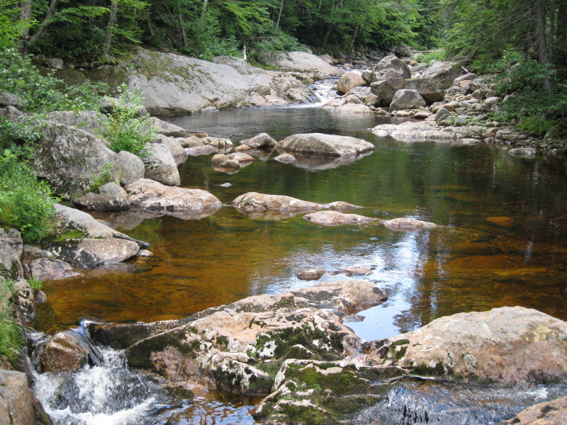 A bit farther along, the supports of the former Spider Bridge could be seen through the trees. It's hard to believe this hiker's footbridge could be knocked off its lofty perch, but this wasn't the first time it had happened. The Wild River sometimes lives up to its name. This bridge won't be replaced.
 Just upstream, the Wild River Trail and Black Angel Trail cross the river. With the current low water level, this was a fairly easy rock-hop. In high water, 'twould be dangerous.
 On the far side, the Wild River Trail turns L at a four-way junction, and in 0.7 mi. of smooth railbed walking, reaches the Spruce Brook Tentsite. The shelter here was removed a couple of years ago and replaced with three nicely sited tent pads located on a spur trail that climbs into the woods behind the old shelter site (which itself is a Revegetation Area).
This is the third and highest tentsite, tucked into hardwood forest.

Across from the shelter site, a path leads down to a scenic spot on the Wild River, just downstream from its confluence with Spruce Brook. After my hike, I looked at an old copy of The Country Northward, an entertaining narrative by Daniel Ford about a two-week backpacking trip through the Whites in the 1970s. In the chapter about his hike through the Wild River Valley, there is a photo of this same river scene. The major difference is that the big boulder seen in the foreground here was not present - more proof of the power of the river.
 Just beyond the tentsite, the trail crosses Spruce Brook, which flows for miles down from the high basin between Carter Dome and Mt. Hight.
 The next stretch of trail is among my favorites in the Whites, leading through a fine hardwood forest with frequent peeks at the river.
 This railroad artifact was right beside the trail. Afterwards I emailed this photo to Ben English, Jr., White Mountain historian and railroad enthusiast. Ben wrote back, "It looks to me as if it was a bearing for an axle or a shaft to turn in." Interesting stuff!
 A peaceful hardwood glade alongside the trail.
 Easy valley strolling through here.
 At 4.5 mi. the trail crosses Red Brook, which flows down from a series of beaver ponds at the SE base of Carter Dome. The trail crosses ledges near the top of a cascade, where the brook plunges into the Wild River.
 The trail leaves the railroad grade after Red Brook and becomes rougher. Farther up the valley I made a short side trip down Eagle Link to check on its two stream crossings on the floor of the valley.
 I'm not sure if the first crossing is the Wild River and the second (shown here) is a tributary, or if they are both part of the Wild River as its splits and rejoins. A mystery worth investigating some day.
 Back on the Wild River Trail, which takes on a wilder character as it continues SW up the valley.
 One brushy section near the Wild River was amply overgrown.
 A placid stretch of the ever-dwindling river.
 This stretch alongside a bog reminded me of my recent journey through the valley of Shoal Pond Brook in the Pemi Wilderness.
 Muddy, boggy, brushy sections alternate with corridors through stark spruce forests.
 One of three trail crossings over the Wild River in the upper valley.
 The trail runs along higher, drier ground as it approaches the No Ketchum Pond area.
 Alders line the river at the last crossing.
 Beyond this crossing, the trail skirts some fine birch glades that grew in after a great fire in 1903 in the upper Wild River Valley. Supposedly it was started by careless campers who were fishing at No Ketchum Pond (whose name does not portend a fruitful angling expedition). Fueled by logging slash, the blaze consumed more than 12,000 acres.
 Perkins Notch Shelter was built in the late 1950s, and its best days are (or were, as it may be gone by the time you read this) far behind it. When I got here, Sarah Jordan of the WMNF Heritage program was documenting the structure in anticipation of its dismantling. Note the tape measure at the lower R.
 Near the shelter site there's a view up to Rainbow Ridge, the SE spur of Carter Dome.
 There are several herd/fisherman's paths, in various states of muckiness and overgrowth, that lead down to the srubby fringe of No Ketchum Pond, a long, narrow pool of water surrounded by lush grasses. I followed one of the relatively drier routes down to catch the unusual view to the three peaks of the Carter Dome massif. When I got down here, I realized there was a large bull moose foraging on the far side of the pond! He is visible to the R of center in the photo below.
 He raised his great head, with velvety antlers half-formed, and peered back at me.
 He was, indisputably, the king of No Ketchum Pond. After a few moments, he gave a loud and startling snort, turned, and galloped like a horse off to the east. I have never seen a moose move so fast, and I was glad it wasn't in my direction.
After he disappeared into the forest, I ventured a few steps farther out to see the full spread of Rainbow Ridge, Carter Dome and Mt. Hight.
 Unfortunately seats are pretty hard to find in this boggy area. I did find a rock suitable for a late lunch at the end of another path. Birds around the area included Cedar Waxwings, White-Throated Sparrows (still singing with their plaintive whistle), a Common Yellowthroat, and a Swamp Sparrow.
 From the rock you can see the bog that is just east of No Ketchum Pond.
 Heading back, late afternoon sun on a birch glade.
 I made a side excursion up the East Branch Trail to its high point on a shoulder of Black Mountain.
 On the way up it passes through a boggy area with no visible footway, reminiscent of the obscure section of the Lincoln Brook Trail in the Pemi.
 Back along the Wild River Trail, I made a short off-trail excursion to look at another bog. I find this upper valley fascinating, though Carol rolls her eyes when I start rhapsodizing about bogs and beaver ponds.
Farther back down the valley, I made another very short side trip down to a scenic ledgy area on the river - would love to see this spot with more water flow.
 Another neat ledgy spot that is visible from the trail. It would be easy to spend a day just exploring these kinds of places along one stretch of the river. There are many treasures to be discovered in the Wild River Valley.
Very wild indeed Steve! Quite an adventure! And, to see such a magnificent bull moose in such a wild and remote location was icing on the cake!
ReplyDeleteIt appears that your camera is behaving properly after it's "hiccup" a few weeks ago when you were in the Pemi!
Just a sidelight, every time I see mention of the Eagle Link Trail it reminds me of the time that I met a trail-runner near the junction of the East Branch Trail and Wild River Trail. This guy was doing a 25-mile loop which he said usually took him about 9 hours to complete. His circuit began and ended at the Baldface Circle parking lot. The trails he used were: Slippery Brook + Slippery Brook Rd; East Branch; Wild River; Eagle Link; and finally, the Baldface Circle Trail.
John
Hi John,
ReplyDeleteThat really was a cool place to see a big moose! I actually bought a new camera (for $64! - it was a discontinued model). Couldn't seem to cure the "lens error" problem on the old one.
25 miles in 9 hours is a pretty fair pace!
Steve
Steve,
ReplyDeleteIt looks like you have had a lot of great experiences hiking. I have a question, hopeful you might be able to recommend a hike/camp for my friends and I.
I enjoy camping off the trail, good views along the way are a must. I cannot find too many stories about hiking and camping off the trail.
I am leaving Friday afternoon, hopefully on the trails by 5:30 and hiking until sun down, most likely half way mark from overall destination. Our plan is to drop our tent somewhere off the trail.
Last hike I went on we hiked up to Zeacliff, the first night we got off to a late start and hiked past the lean to in the dark (we didn't want to stay there) we ended up throwing a tent down a decent way off the trail it the most flat area we could find. Second day we hiked up to the top of Zeacliff and set up shop right off the cliffs to the right (you can tell someone had cleared it out for camping), we left our gear and hiked down to the pond for the day.
Looking for something similar, might be a long shot but figured it anyone could suggest something it would more than likely be you. White Mountains please!
Have you read Nature and Renewal: Wild River Valley & Beyond? It's a great book about the natural and man-made history of the valley.
ReplyDeleteHi Ryan,
ReplyDeleteHere's a possibility for you: the designated tentsite on the Davis Path near the Giant Stairs. The clifftop on the Giants Stairs is a cool viewpoint. On Friday night you could hike 2 easy miles in on the Rocky Branch Trail from the end of Jericho Road (off Route 302) and use either the shelter or tentsite at Rocky Branch Shelter #1. On Saturday hike up Stairs Col Trail and along Davis Path to the tentsite. You'll have to carry water up there since it's on the ridge. Another couple of viewpoints you can visit nearby are the ledges on Mt. Resolution along the Mt. Parker Trail.
Good hiking (and camping),
Steve
Simon,
ReplyDeleteThanks for your comment - I have read that book and I look at it whenever I visit Wild River. I meant to mention it at the end of the post and forgot - thanks for the reminder. I also enjoy reading "The Wild River Wilderness" by D.B. Wight and the Wild River chapter in "Logging Railroads of New Hampshire's North Country," by Bill Gove.
Steve
Really nice, Steve! I can't decide if the Wild River Valley or the Pemi is my favorite place... so much beauty in both wildernesses. Thanks for sharing the great photos!
ReplyDeleteThanks, Chris - that is a tough choice!
ReplyDeleteSteve
Trip report from August 2014. The wild river valley is not what it used to be. Spruce brook tent sites are now adorned with piles of human waste because are no appropriate facilities to accommodate the usage. Very disappointing.
ReplyDeleteI am heading there this Friday. Is there another spot on the river that you recommend to camp.
DeleteYou might be able to find a nice spot along the stretch of Wild River Trail between the Black Angel Trail junction and Spruce Brook. There might also be possibilities near the Wild River Trail/Eagle Link junction. Perkins Notch is a neat place but you might run into a situation similar to Spruce Brook - hard to say. Enjoy your trip!
DeleteSteve