
On a cool, overcast day, I made a long loop around the base of Owl's Head Mountain in the western Pemigewasset Wilderness. The impetus for this route was a need to check on the notoriously obscure section of the Lincoln Brook Trail across the high saddle on the NW side of Owl's Head. I also viewed this as a sort of celebration hike for the 100th anniversary of the Weeks Act. This part of the Pemi was clear-cut and burned a century ago, but thanks to the Weeks Act, which enabled the creation of National Forests in the East, these lands became part of the WMNF in the 1930s and are now once again lushly forested. This is a route with much fine backcountry scenery, and a liberal dose of J.E. Henry era logging history as well. Because there are 23 stream crossings, I chose a time of low water levels to make this journey.
This route is about 20 miles long, so to save time, and wear on my feet, I rode my mountain bike for the 2.9 mi. segment on the Lincoln Woods Trail. After stashing the bike in the trees, I continued on foot, crossing the bridge over Franconia Brook into the Pemi.
 The gentle railroad bed incline on the Franconia Brook Trail made for easy walking. Soon I came to the first of three crossings of Camp 9 Brook.
 Along the beaver pond bypass between the second and third crossings of Camp 9 Brook, I stepped down to the edge for this view of the cloud-capped south peak of Owl's Head rising above the wetland.
A half-mile farther I turned L onto the Lincoln Brook Trail.
 One of the major concerns on this trail section, part of the standard, non-bushwhacking route to Owl's Head, is the big crossings of Franconia Brook and Lincoln Brook. While not really easy, both were quite manageable today. Looking upstream on Franconia Brook.
 Ditto on Lincoln Brook.
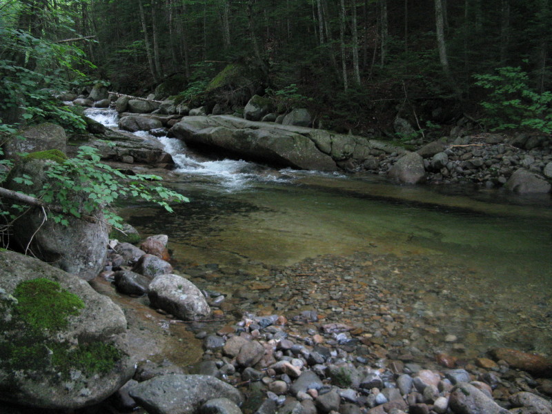
 One long section of the walk up Lincoln Brook Trail on the SW side of Owl's Head features several scenic cascades and pools. At this spot, a dry slab beckoned for a sit-down break.
An inviting pool. This is a beautiful, secluded valley.
 This part of the hike could be called the "Lincoln Brook Show."
 After crossing a nameless side stream, the trail picks up another old railroad grade.
 Beyond the crossing of Liberty Brook is the site of J.E. Henry's Camp 12. I poked around here for a few minutes; didn't find much other than these mossy old railroad ties...
 ...and a crumpled bucket.
 The second crossing of Lincoln Brook, not far below the Owl's Head Path.
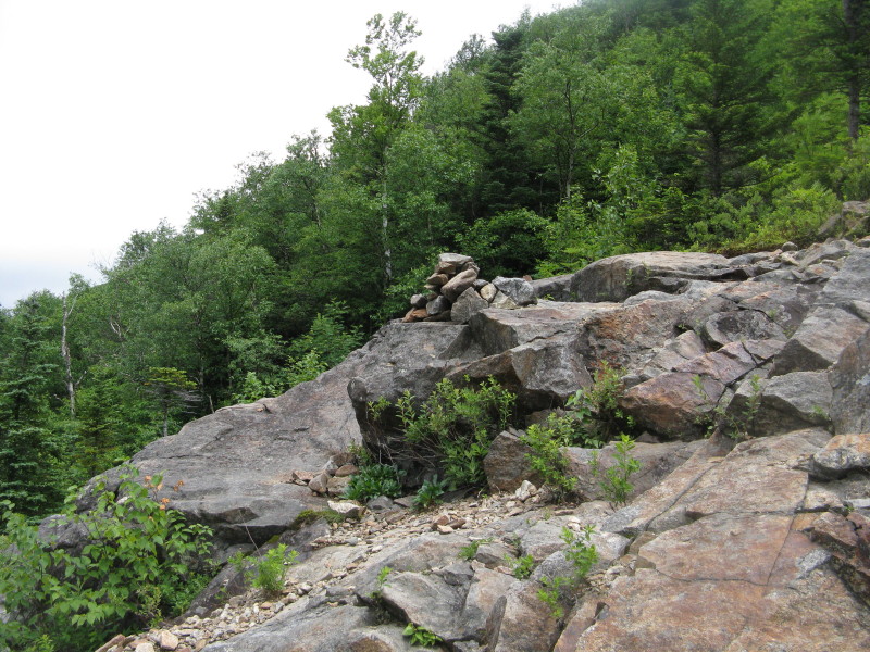
The gateway to the Owl's Head Path - peakbaggers should have no trouble figuring out where to go! Another clue, were these markings to disappear, is the stony slide outwash that the Lincoln Brook Trail follows in its last 200 ft. before the junction.

Today's itinerary called for a climb partway up the slide for some views. No time to trek all the way up to the wooded summit, and it wouldn't "count" anyway since I rode my bike partway in. The bottom part of the slide is a mix of dirt/gravel and loose rock.

Higher up, where the slide is more open, there are ledges to scramble up. My objective was this fine ledge perch at about 2950 ft.
 The summits of the Franconia Range were in the clouds, though the top of Mt. Flume did poke out for a moment. This view takes in the eastern ridges of Mts. Flume and Liberty.
 Looking down the slide during one of the few brief breaks of sun on this grey day.
 North to the headwall of the Lincoln Brook valley, where I would soon be heading..
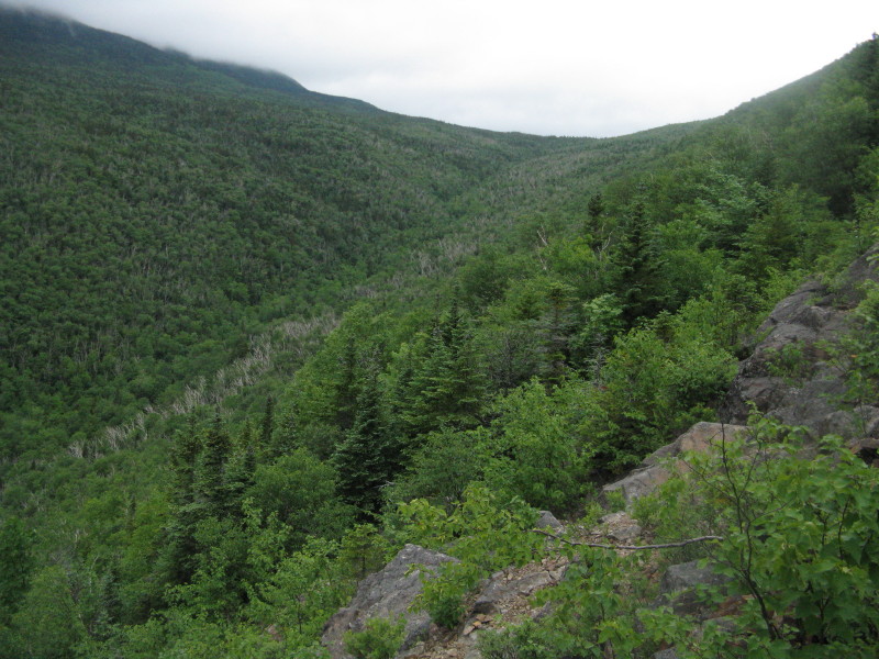 This ledge scramble is a little trickier on the descent, with a dropoff on the R.
 Beyond the point where peakbaggers turn off, the Lincoln Brook Trail is lightly traveled, with a narrower and less-defined footway.
I had planned some time to explore in this upper valley, beginning with a short bushwhack down to a cascade on Lincoln Brook that I had visited back in 1994, the last time I did this loop. A lovely spot in a steep little ravine.
 Back on the trail, a ferny birch glade.
 I dropped down to another cascade on the brook, located just north of the spot shown here, where the brook that drains the Lincoln Slide drops into Lincoln Brook.
I believe this may be what is shown as "Lincoln Brook Falls" on the various maps of the J.E. Henry logging railroad network. I've never seen any other reference to this name.
 Farther north the trail makes another crossing of Lincoln Brook.
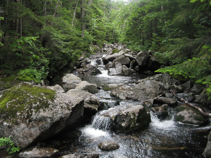 My next objective was a beaver pond on a plateau at the base of Franconia Ridge. This required a little longer bushwhack. I had also visited this in 1994, but it took a while to find it. Today I had a little better luck, starting the whack off through some Kilkenny-like birch glades that grew up after the great Owl's Head fire of 1907, which burned more than 10,000 acres.
The woods did get thicker, and to reach the shore I had to push through some alder thickets. Unfortunately the views of Lafayette, Lincoln and the Lincoln Slide were (with a nod to Pink Floyd), obscured by clouds.
 There is an old beaver dam at the pond's south edge.
 From the other side there was an unusual view across to the long, forested ridge of Owl's Head. In 1908, an AMC group looked from the top of Mt. Lafayette down into this area, a year after the great fire. One of those hikers wrote that this had become a "country of charred stumps and dried stream beds." Hard to believe, looking at this verdant forest in the full flush of early summer greenery.
 Back on the trail, I continued north to the high plateau between Mt. Lafayette and Owl's Head. The trail provided some pretty good walking on this upland slope.
 After a long section across this shelf, the trail dipped to cross a small branch of Lincoln Brook.
Here, for about 0.2 mi., it all went bad in a mess of mud wallows, fallen trees, slick logs, and overhanging brush that was wet from a substantial rain shower that had moved in just after I returned to the trail from the beaver pond.
 The trail is primitive and hard to follow through here, and I could see how several hikers had gotten lost out here in the last few years. This vast, flat, boggy area is a no man's land, nine miles from the nearest trailhead. If you stray off to the north, you could wander for a long time in dense, soggy forest wracked with blowdown.
 This section reminded me of my recent trip on the Church Pond Trail, only it's far more remote.
 Then the trail returns to drier ground, though it remains overgrown. The next section was an early 1990s relocation, and there are still many faded yellow blazes visible. A wild and desolate forest out here.
 One piece of recent axe work was evident.
 One of the bogs alongside the trail. On clear days there would be some glimpses of Mt. Lafayette.
As it began to descend into the Franconia Brook valley, the trail became rocky and rough, and had a few more obscure sections.
 Farther down, the footing improved, with more birch glades.
 After a long, wet descent, the trail crossed a western branch of Franconia Brook below a nice cascade.
 For the next quarter-mile, the trail led along a gorgeous string of cascades and pools.
At 5:30 pm I arrived at Thirteen Falls, one of the most picturesque spots in the Pemi. Though there may well be that many waterfalls in the vicinity, it was named after J.E. Henry's Camp 13. The best spot is this expansive slab with a cascading stream and a view up to the looming north ridge of Owl's Head. I took a half-hour supper break here, fueling up for the 5.2 mi. walk back on the Franconia Brook Trail to my bike.
 There were several clusters of mountain avens blooming around the ledges. These semi-alpine plants are found only in the White Mountains and Nova Scotia.
 Looking up at the ledges from the bottom. There was no one else around, despite the proximity of the Thirteen Falls tentsite. In fact, I saw only two other hikers during the entire trip, both solo Owl's Head peakbaggers.
 Iron pins in the ledge - was there a logging bridge here?
 This cascade is seen from the Franconia Brook Trail just below the northern junction with Lincoln Brook Trail.
 Then it was time for nice RR grade strolling, through the fine hardwood forest that cloaks this broad part of the Franconia Brook valley.
With the low water levels, the crossings of Twin, Redrock (shown here) and Hellgate Brooks were a breeze.
 The only spot in about 5 miles where Franconia Brook can be seen from the Franconia Brook Trail.
 It started raining again shortly after I crossed Hellgate Brook, resulting in misty views looking across the beaver ponds to the lower west spur of Bondcliff.
 There was just enough daylight left to negotiate the bumpy bike ride back down the Lincoln Woods Trail, on which you can coast nearly the entire way.
Though the weather wasn't the best, it was a memorable tour through the western Pemi. Thanks to the Weeks Act it will be a journey available for generations of hikers to come. For more on the Weeks Act centennial, visit weekslegacy.org.
Nice little walk Steve. I need, and want spend more time in the Pemi.
ReplyDeleteI must comment about that spot along Lincoln Brook you mentioned. My first trip Owls head was on a beautiful, sunny, late summers day. The way the sunlight filtered through the hard woods onto Lincoln Brook in that area was one of the most beautiful things I've seen. That,coupled with the fact you really sense the isolation there, makes it a very special spot I think. I bring it up ever time someone mentions hiking to Owls Head. I'd say "Lincoln Brook Show" pretty much nails it.
Thanks for sharing,
Joe
Thanks, Joe! Nice description of that section along Lincoln Brook. I try to talk that up when people ask what the trek to Owl's Head is like. The Pemi rules when it comes to remoteness in the Whites.
ReplyDeleteSteve
I was just out to Owl's Head last week and sat and ate lunch at probably the same exact spot in the slide that you stopped at. I went to the summit first and came back to that spot, thinking I had the best lunch spot in all of the Pemi that day. Since I needed the Owl for the list, I did not have the luxury of biking, but that sure does sound like a great idea! Here's my trip report from last week: http://nh48.wordpress.com/2011/06/29/bagging-the-owl-41-owls-head-6-28-11/
ReplyDeleteExcellent report and photos! Sounds like you had a nice quiet day out there.
ReplyDeleteThat is a great lunch spot!
Steve
That's funny, I made the same loop this past week-end as a 3 days backpacking trip without having read this TR. I gotta ask, did you went to Camp 14 ??? I saw boot prints in the mud when I went ? :-)
ReplyDeleteHi JS,
ReplyDeleteNope, those weren't my prints. Did go there a couple of times in the 90s en route to the pond. Did you see any good stuff there?
Steve
Another wonderful report, Steve! And now, thanks to you, I have yet a few more cascades to add to my list of places to visit! Hmmm - couldn't you have made them a bit more accessible, instead of 10 miles out? :) Just kidding! Thanks for sharing this great report and photos!
ReplyDeleteThanks, Chris - and I'm sure there are more cascades on that upper section of Lincoln Brook. You can hear them from the trail. Unless there's an old photo somewhere, it may be hard to determine what actually is the "Lincoln Brook Falls" shown on the logging RR map.
ReplyDeleteSteve
Ah, here's the Pemi trip you were talking about today! Reading this made me excited about my next trip to the Owl(and it's coming soon).
ReplyDeleteHi Tony,
ReplyDeleteHave a good trek to the Owl! Great area out there.
Steve
Great report, Steve. My sons and I attempted a similar hike last summer, but didn't have nearly the success that you did. After summitting Owl's Head, we attempted to continue north to Thirteen Falls, but lost the trail many times. Those boggy areas in your pics look familiar, but I wasn't convinced we were even on the trail, and I didn't want to suffer the embarrassment of seeing our names in the paper as "lost hikers", so we turned around and camped off the trail, then went back out via the Lincoln Brook Trail. A great hike, but I would have really liked to see Thirteen Falls and circumnavigate the Owl. Maybe some other time.
ReplyDeleteThanks, BC - and don't feel bad about turning back. I know of at least two instances in the last several years of hikers losing the trail on that stretch and needing assistance. It's one of the most obscure trail segments in the Whites, and who knows what it looks like after Irene!
ReplyDeleteSteve