
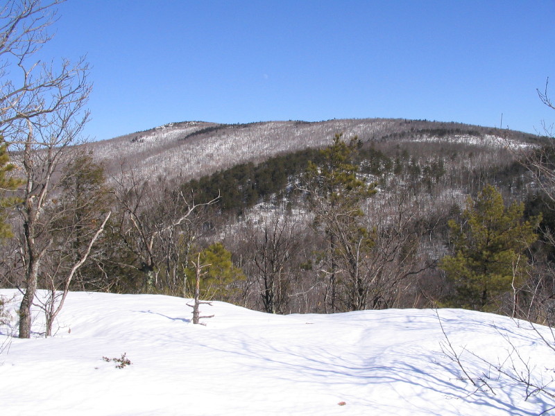
Black Cap Mountain, the highest of the Green Hills east of North Conway, may be a pint-sized peak at just 2369 ft., but it offers up a king-sized panorama that shames many a 4000-footer summit view. When Hurricane Mountain Road is open (not yet this spring), the easy 1.1 mile climb to Black Cap is near the top of the "biggest bang for the buck" class. Here is a view up to Black Cap from the summit of neighboring Peaked Mountain.
When Hurricane Mountain Road is closed, or if you're looking for a long woods ramble with a great view at the end, there is an alternate route to Black Cap from North Conway, via the Black Cap Connector, that reaches the summit in 4.5 miles. I hadn't been on this trail for quite a while, and was in the mood for a mellow all-day hike on bare ground. The route starts at the parking area for the town of Conway's Pudding Pond Conservation Area, located on Thompson Road (off Artist's Falls Rd., just south of downtown).
 In a short distance you come to a major intersection. The junctions in the Nature Conservancy's Green Hills Preserve sport attractive new trail signs.
 After the Middle Mountain Trail splits off, the Black Cap Connector makes a rolling traverse through a young hardwood forest.
 Beyond the junction with the Peaked Mountain Trail, the Black Cap Connector wanders up the valley of Artists Brook, then makes a long, moderate, winding climb up onto the slope behind Peaked Mountain. In one section the treadway shows that some of the heavy rainstorms from the last couple of years have taken their toll.
 About 2 1/2 miles from the trailhead I crested a rise and emerged on an oak-wooded plateau in the hinterlands of the Green Hills. This area has a surprisingly remote feeling just a short distance from the bustle of the North Conway strip.
Very pleasant walking through here.
 Then the Mason Brook Snowmobile Trail joins from the right.
 Just beyond this junction the Connector veers right onto a relocated footpath that climbs up through some interesting ledgy terrain.
 One ledge along the trail provides a filtered look at Middle Mtn. and the distant Ossipee Range.
After 0.3 mile the relo rejoins the original route along an old road that serves as a snowmobile trail in winter. This part of the trail is popular with mountain bikers in summer. It meanders for a long ways at an easy grade through oak woods that were badly damaged by the 1998 ice storm.
 Farther along the old road ducks into a spruce-shaded swampy area - a complete contrast with the dry, sunny oak woods.
 This sharp rocky col reminded me of some of the ridgetop notches in the Catskills.
 Sadly, there was evidence of recent illegal ATV use on the trail. They sure can tear up a trail in a hurry.
 A short connecting trail called Black Cap Spur leads through stunted hardwood growth from the Connector to the summit of Black Cap. Trail maintainers are fighting a difficult battle with erosion on this gravelly surface.
Open ledges mark the summit of Black Cap, though the best views are a little ways down the NW side along the Black Cap Trail (the route that leads up from Hurricane Mountain Rd.).
 On the west side of the summit a rock is inscribed in honor of Anna Stearns, whose vision and generosity led to the creation of the Green Hills Preserve in 1990.
It was a cool, crystal-clear spring day. Time to settle in for some serious viewing.
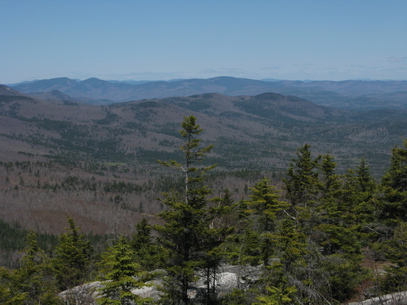
This vista looks west down the Artists Brook valley to the Saco valley, the Moats, Mt. Chocorua (far L) and the Sandwich Range.
 The high peaks of the central White Mountains stretch across the horizon. All told the summits of 29 4000-footers can be seen from Black Cap - just two fewer than can be spotted from Mt. Adams, which is 3400 ft. higher. When it comes to views, location is at least as important as elevation.
 Kearsarge North is an impressive sight to the north, with the snow-marbled Presidentials beyond.
A closer look at the Presys. The Gulf of Slides and Huntington Ravine are well-displayed, while Tuckerman Ravine is hidden from view. Bartlett Mtn. in the foreground.

The intriguing trailless range consisting of (L to R) Rickers Knoll, the Gemini and Mt. Shaw extends NE from Kearsarge. The Baldface Range is behind on the L.

Farther to the NE are the mountains around Evans Notch, including the Royces on the L and broad-spreading Speckled Mtn. in the center. In the distance I could see Saddleback Mtn. and Mt. Abraham, Maine high peaks way up in the Rangeley Lakes region.
 The ledgy climb from the best viewpoint back to the summit.
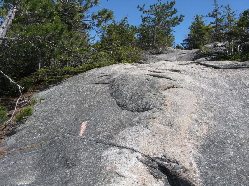 On my first pass across the summit I had missed the trail signs, which are tucked in under a big old spruce tree.
A blazed side path leads out to a vista towards SW Maine, once open but now largely restricted by tree growth. You can still make out the Kimball Ponds and various peaks such as Streaked Mtn. across the horizon.
 I had an enjoyable amble back down the Connector, and met my first hiker of the day about a mile and a half from the trailhead. If you're willing to take the longer route, solitude can be found on the trails, even on the outskirts of North Conway.
Hi Steve
ReplyDeleteInteresting hike (in my neck of the woods).
I’ve done Peaked but not Black Cap that way.
Out of curiosity have you ever hiked Bartlett Mnt? I found an abandoned trail from the top of Kearsarge ledges that goes over there but I didn’t know how well known it is.
Also, I’m working on a “project” to find the old trail that went from Ducks Head to Iron… I’ve found several large cairns from Ducks Head (starting behind the Red Fox, found the old ski hut) to the base of Green Hill but I haven’t gone all the way to Iron yet. Have you ever done that?
Kind Regards (met “Ann and Ken” on top of Stanton a while back; they said they are regulars to your shop, said to say “Hi”, and you were THE person familiar with the Whites)
Charlie Sielicki
Merrimac, MA (& Glen NH)
Hi Charlie,
ReplyDeleteThanks for posting! I've never been to the summit of Bartlett, only halfway across to a view ledge looking north in the saddle between Bartlett and Kearsarge. That was on snowshoes, so I couldn't tell if there was a herd path going across. I've heard from several folks that there are other unofficial paths coming up Bartlett from the bottom on the west side.
I haven't been across that east ridge of Iron. I was looking at that from Black Cap the other day. Lots of potential view ledges. I'd be interested in hearing about your explorations up there.
Ken and Ann are fine folks - they're out on the trail almost every weekend year round. Ken is one of the best photographers in the mountains - we sell his hiking scene notecards and laminated view panoramas, one of which is from Kearsarge North.
Good hiking,
Steve
Awesome write up and pictures. Gives me something to aim for if I ever plan a trip to NH.
ReplyDeleteHello, I was wondering if you have ever gone to this mountain from Cranmore? Specifically, I am looking to sneak off a family ski trip for an afternoon and either ski from Cranmore to Black Cap; or take what looks like an access path down the valley and back to teh lodge. Doable?
ReplyDeleteAs I recall, the trail from Black Cap to Cranmore is mostly gradual, but there are a couple of short steep spots. Partway along there's a mountain bike trail called Red Tail Trail that drops down to Hurricane Mountain Road. Have fun!
ReplyDeleteSteve
I'm hiking black cap in a week with my boyfriend and now looking forward to it more thanks to your pics
ReplyDeleteEnjoy your hike - Black Cap is a great spot!
ReplyDeleteSteve
Any idea if Black Cap Connector is skiable? I am looking to do a loop where I start off Thompson Rd, up the Connector, and then eventually make my way down a Cranmore ski trail to the base lodge.
ReplyDeleteI think it would be skiable - I don't recall many steep pitches on it. It should be packed by snowmobiles above the junction with the Mason Brook Snowmobile Trail. The hiking trail connecting down to the top of Cranmore does have a couple of steep pitches on it. Good luck!
ReplyDeleteSteve
How well marked or easily followed is this route? I'm a local and always looking for less traveled trails to hike on holiday weekends. This one looks ideal, but I'm not up for getting lost.
ReplyDelete