Tuesday, July 29, 2025

Floor of King Ravine: 7/28/25


On yet another hot, humid day, with the haze enhanced by wildfire smoke, Daniel Newton and I took a leisurely hike into the floor of King Ravine. This spectacular glacial cirque, gouged into the northern flank of Mount Adams, is one of the wonders of the White Mountains.
 
We were lucky enough to snag a spot in the Appalachia parking lot, saving a bit of steamy road walking.


For the approach we used the standard route via Air Line and Short Line, passing this large hemlock along the lower part of Air Line.


The lower part of Short Line ascends through a beautiful hardwood forest.


Short Line coincides with Randolph Path for 0.4 mile.


Heading onto the upper part of Short Line.


Farther up, Short Line traverses a tedious section of slippery rocks. Due to the previous day's rain showers and the high humidity, the rocks in the woods were wet and slick. 


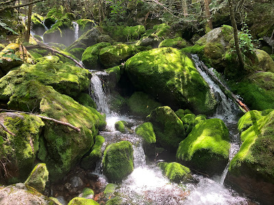
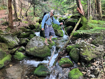
A scenic reach of Cold Brook.


The trail of the day.


Vivid greens on Cold Brook.


Sweet spot on a hot day.


Mossy Fall, considered the entry point for King Ravine.


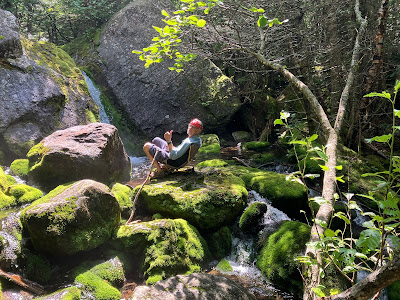
Daniel gives himself a front row seat to Mossy Fall.


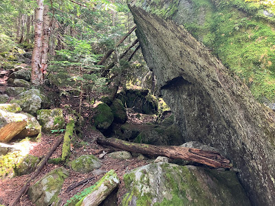
After a nice break by the waterfall, we headed up into the ravine, soon passing this overhanging boulder.


Above here is where the boulder scrambling begins.


This one was tricky because the rock was damp and slick. It's steeper than it looks.


Boulders at all angles.


Partway up the climb into the ravine Daniel found a faint route that led us safely out to comfortable boulder perches with wide views.


This is the lower end of the "rock glacier" that covers the floor of King Ravine. Nowell Ridge in the background. The boulders came off the headwall and sidewalls of the ravine during the most recent glaciation and have tumbled down to the floor. They are very slowly creeping downslope.


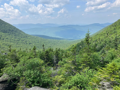
Hazy view out to the Pliny Range, some Kilkenny peaks, and part of the Crescent Range.


Some inaccessible crags on the steep flank of Durand Ridge.


Daniel gets a close-up shot of ring lichens.


A lover of scrambling, Daniel carefully navigated a weaving route through the boulders to the projecting rock seen in the center of the photo.


He made it!


Daniel is a tiny figure gazing up at the great headwall of the ravine. King Ravine was first ascended in 1857 by a party led by Gorham guide James Gordon and the Rev. Thomas Starr King, who vividly described the adventure in his classic The White Hills: Their Legends, Landscape and Poetry. He called it "the grandest of all of the gorges that have been cloven out of the White Hills." The ravine was subsequently named in King's honor. The King Ravine Trail was opened by Randolph guide Charles E. Lowe in 1876.


Back to the trail and more boulder scrambling.


The boulder scrambles seemed a little harder than they did the last time I came through here, 18 years ago. This was a tough spot, made spicier by the hole down to the left. It was even trickier to descend, and I will confess to making a short bushwhack around this spot after failing to find a suitable foothold. Due to the steeply angled boulders with deep holes between, this is not a trail on which to bring your dog. Sure, there are some that have done it, but in general it's strongly discouraged. 


This section of trail features a quick succession of scrambles.


A full body workout is guaranteed.


I removed my bulky pack to get under this overhang.


After the multiple scrambles, the last section up to the junction with Chemin des Dames and the Subway is a normal mountain trail.


The Chemin des Dames (ladies' road) is named after a road in France that was strategically important during World War I.


A good view of the imposing headwall here.


Another angle.


The Subway - a blazed route through, over and under a maze of boulders - is a unique feature of King Ravine. The Randolph Mountain Club maintains all the trails in the ravine.


Where the Subway goes.


This was Daniel's first visit to King Ravine, so naturally he had to drop in.


Up and over.


Amidst a sea of stone.


While Daniel was weaving through the Subway, I headed up the "Elevated" section of King Ravine Trail to a big slab of ledge suitable for relaxing while enjoying the views.


After exiting the Subway, Daniel joined me and set up his portable chair for a sojourn in the sun. Behind him is the route followed by Chemin des Dames as it climbs steeply (800 ft. gain in 0.4 mile)  to Durand Ridge. 


Peering up at the upper route of the King Ravine Trail, which follows a strip of talus up to the dramatic slabs of the Gateway, seen left of center.


This was a hard place to leave.


Parting shot.


Back down through the boulders.


Evening at Mossy Fall.


We took a slightly longer route for the return trip, following King Ravine Trail down to the NW and crossing Cold Brook along the way.


At the five-way junction known as Pentadoi, we turned onto the Amphibrach.


This trail provides a pleasant easy to moderate descent, with generally good footing - unusual for the Northern Presidentials.


After a quick stop to admire Cold Brook Fall, we exited via The Link and a concluding stroll on the Presidential Range Rail Trail.


Friday, July 25, 2025

Castle Ravine Ramble: 7/24/25

Another trip to the Northern Presidentials, this time to enjoy a cool walk on the floor of Castle Ravine on a hot, sunny, humid day. I bushwhacked to a familiar pair of old slides on the west wall of the ravine for some views, then returned to the trail, went a bit farther up the ravine, and ascended the notoriously steep and rough section of The Link that goes up to the Castle Trail. The lower 3.5 miles of Castle Trail provided a descent route back to the trailhead.
 
Mount Jefferson and The Castles were looking good as I set off mid-morning on the Castle Trail. 


I was surprised to see that the powerline crossing had recently been weed-whacked.


After crossing the Israel River on slippery rocks, I ran into the volunteer adopter for Castle Trail (senior moment - name forgotten) and his faithful dog, Ellie. He had been cleaning drainages and doing some brushing. That's a lot of trail to maintain - thank you!


Nice hardwood stroll on the next section of Castle Trail.


Streamside scramble on Israel Ridge Path. 


The cool waters of Israel River.


A Presidential path less travelled.


After a crossing of Israel River (despite low water level, I used crocs due to awkward slippery rocks), I made a short bushwhack to see the Forks of the Israel, where Castle Brook (R) and Cascade Brook (L) unite to form the Israel River.


Shortly after another tricky crossing, I came to the much easier third crossing on Castle Ravine Trail, a lovely spot with cascades above...


...and below.


The trail crosses over this debris flow levee deposited by an old slide, either from the November 1927 storm or the September 1938 hurricane.


The overgrown track of the old slide comes right down to the trail.


A serene stretch of trail alongside the brook.


A debris flow levee from another old slide, just off trail on the other side of the valley, at  the fourth crossing.


After the fourth crossing, the Castle Ravine Trail ascends along the lower flank of Israel  Ridge, passing this peek up at the steep wooded wall of the  lower Castellated Ridge. 


Very nice section of trail.


At my chosen locationt to bushwhack to the two parallel slides on the west wall of the ravine, I dropped down a steep slope and crossed Castle Brook at this attractive open spot.


This Google Earth screenshot shows how the two slides appeared in 1999. The slide on the right was fresh, probably having fallen in 1995. The slide on the left fell around 1970. Curiously, the newer slide is almost completely revegetated now, while the older  slide still has a sizeable  open area.. 


I had  gotten good views of the Castle Ravine headwall from the 1995 slide back in 2009. After  crossing Castle Brook, I pushed into the dense deciduous growth that has overtaken this slide track, seeking any remaining hint of a view.


The alder growth is something to be reckoned with.


I did find an opening where I could see over the shrubs, here looking at Israel Ridge and the craggy viewpoint known as Emerald Bluff.


And there still was a vista up to the headwall of Castle Ravine.


Zoomed.


I thrashed farther up through the brush...


...hoping this track would open to the sky.


It looked promising, but didn't deliver.


Time to push across the slope to the vintage 1970 slide.


That's more like it.


A northerly view from the top of the open slide.


(L to R): The long east ridge of Mt. Waumbek, South and North Weeks with Mt. Cabot peering over between them, Unknown Pond Ridge, Rogers Ledge and Deer Ridge. Long Mountain faintly visible in the distant haze.


I spent an hour here relaxing in the sun with a nice breeze and minimal bugs.


An excellent sitting rock.


One of several white pines that have seeded in on the slide.


An even better view from the lower part of the slide, with Mt. Bowman on the left.


Peering up at The Castles on Castellated Ridge.


A roadblock on Castle Brook.


A cozy nook in the ravine.


A fern glade traversed while climbing back to the trail.


I continued farther into the ravine, passing the lower junction with The Link.


This area has a primeval feel to it.


Junction with the Emerald Trail, which climbs steeply to the fabulous viewpoint at Emerald Bluff on Israel Ridge.


On to the notoriously steep and rough climb up the southwest wall of the ravine to the Castle Trail on Castellated Ridge.The six-mile section of  The Link extending from Appalachia to the Castellated Ridge was opened by  the great trail-builder J. Rayner Edmands in 1893. The section from Castle Ravine up to the ridge was sometimes referred to as the "Old Link."  


Here are a few of the "greatest hits" from this seldom-traveled section of The Link.


Wild and rugged.


A somewhat sketchy spot crossing a drainage.


Mossy rocks galore.


Classic Link terrain.


Partway up, a restricted view.


Onward and upward.


A full body workout.


Yikes!


Near the top was what I thought was the trickiest spot,


I was happy to see this sign at the Castle Trail junction.


The upper mile of the descent from here on Castle Trail is some of the nicest walking in the Presidentials - fern-lined with good footing.


But you can't get down off a Presy ridge without paying the price of admission.


A long section of steep descent.


Going up, this huge boulder marks the start of the steep stuff.


Farther down, a gorgeous hardwood forest.


Good drainage cleaning work by the trail adopter.


Mt. Jefferson at dusk.