On an HHH day - hazy, hot and humid - with a chance for afternoon thunderstorms, I planned to check out some recent Randolph Mountain Club (RMC) trail work on the middle part of Lowe's Path, and ramble over a few other trails on the lower slopes. Since the sun stayed out and the storms did not materialize, I ended up climbing the Spur Trail to the Lower Crag for great views of King Ravine, followed by a brief visit to the RMC's Crag Camp. It was a sweatfest from start to finish.
Mine was the only car at Lowe's Store when I started out mid-morning.

That's a long 4.8.

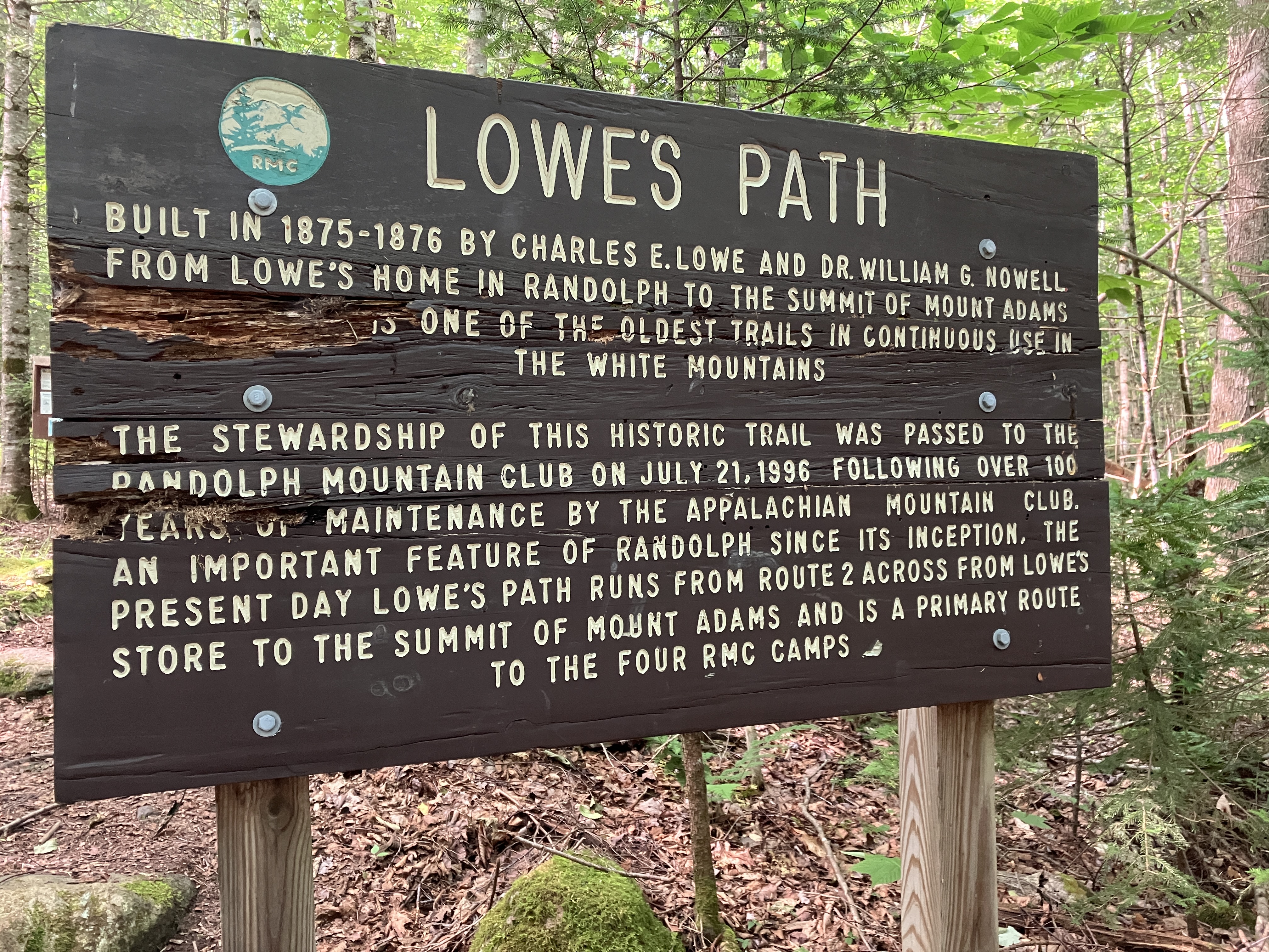
Lots of history on these trails.
There is ongoing construction along the powerline that the trail crosses. The crossing is now made on a wooden platform.

The first mile and a half of Lowe's Path ascends at easy to moderate grades through a nice hardwood forest.

Good axe work by the RMC trail crew.

Whale Rock.

This heavily used path has received lots of trail crew attention over the years. This rock staircase is a short distance below the junction with The Link.

Last summer and this summer the RMC trail crew has been making major improvements at several sites along Lowe's Path. The work has been described in detail in the RMC newsletter, which can be viewed on the club website, www.randolphmountainclub.org.

Work has just begun on this gullied section of trail.

Excellent treadway work in a wet area, completed last year.

The first rock steps in a project that will lead hikers up along the edge of a tricky, slippery ledge.

Lowe's Path becomes steep and rough as it ascends to the shelter known as the Log Cabin.

The first facility at this site was a bark shelter built in 1875 by William G. Nowell and Charles E. Lowe. In 1889-90 Nowell replaced that with an enclosed cabin. The RMC took it over in 1913 and made it available to the public. In 1985 they tore down the old shelter and built the current structure, in a style known as an Alaska trapper's cabin. This summer, through August 14, the Log Cabin is reserved Monday through Wednesday nights for the RMC trail crew as they work on Lowe's Path.

A peek inside.

Last year the RMC crew built this impressive pinned rock staircase atop a nasty, slippery ledge, just above the Log Cabin.

From the shelter I followed the Log Cabin Cutoff across to Randolph Path.

The Cutoff is nearly level but part of it is quite rough as it traverses a sidehill slope.

I descended eastward on the Randolph Path, which also had some tricky maneuvering along a steep sidehill.

This section of Randolph Path is more in the graded style of its builder, J. Rayner Edmands.

Heading up the Spur Trail to visit Chandler Fall, which I hadn't been to in quite a while.

This pretty cascade on Spur Brook is just a few yards up Spur Trail.

Typical of trails in the Northern Presidentials, Spur trail is steep and rough, rising 1300 ft. in its 0.9 mile climb to the RMC's Crag Camp.

Sign marking side trail to Chandler Fall. Near here was the site of Spur Cabin, a private log structure built in 1899-1900 and used by the Torrey and Moore families for many years. Eventually the cabin deteriorated, and the USFS burned it down in the winter of 1929-1930. I made a brief bushwhack foray to a likely location but found no evidence of the cabin.

At Chandler Fall, Spur Brook slides down a large, steep rock slab.

An amber pool gathers at the base of the fall.

There are nice ledges to hang out on at the base of the fall, with a partial view to the north,

Since the weather was holding, and I had much of the afternoon left, I decided to tackle the steep climb up to the viewpoint at 4100 ft. known as Lower Crag. The Spur Trail, so named because it climbs an eastern spur of Nowell Ridge, was cut by Charles C. Torrey in 1900-02, in conjunction with the use of Spur Cabin. Partway up, the trail crosses Spur Brook by the junction with Hincks Trail, which ascends to the RMC's Gray Knob cabin.

Yup, it's steep, though perhaps a bit less rough than some other trails in the Northern Peaks.

The trail moderates for a bit on a beautiful shoulder.

One more steep pitch to reach the Lower Crag.

A short side path leads out to this great viewpoint.

A ledge seat for taking in the view.

A striking late afternoon vista into King Ravine with Mount Adams on the right and Mount Madison on the left. The Knife Edge of Durand Ridge is highlighted under Madison. Also a good look at the boulder field on the floor of the ravine.

A hazy view NE to the Mahoosuc Range.

Zoom on part of the craggy headwall under Adams and John Quincy Adams.

After lounging at Lower Crag for an hour, I climbed another 0.1 mile to Crag Camp, perched on the edge of the ravine at 4247 ft. This was originally built in 1909 as a private camp for Nelson H. Smith. In 1939, when his land lease with the USFS expired, he gave the camp to the RMC. In 1993 the RMC razed the deteriorating building and built an entirely new camp. More information on the history of RMC camps and trails is found in Judith Maddock Hudson's excellent Peaks & Paths: A Century of the Randolph Mountain Club. The RMC also publishes a substantial guidebook, Randolph Paths, for which this writer has been a co-editor along with Judith Maddock Hudson and Doug Mayer.

Down in front of the camp is the Upper Crag, with a startling down-look to the floor of the ravine.

A wide view out to the north, with the Crescent Range seen across the Randolph Valley and peaks of the Kilkenny region beyond.

Another great angle on Madison, Adams and King Ravine.

I took a quick look inside. Amazingly, there was no one around. In fact, after being passed by two fast-moving solo young men down low on Lowe's Path, I didn't see another person for the remainder of the 8-mile hike.

The scoop on Crag Camp.

Dining room with a view.

View from the deck.

A neat place to spend the night, though I have never done so.

Descending along the Spur Trail in slanting late afternoon sun.

This is the only somewhat tricky scramble on the route up to Crag Camp.

From the bottom of Spur Trail I followed Randolph Path a short distance down to the five-way junction known as Pentadoi.

From there I followed a pleasant, less-used section of King Ravine Trail back to Lowe's Path.

King Ravine Trail passes below Canyon Fall at its crossing of Spur Brook.

When I got back to my car at 8:00 pm, it was 82 degrees. A sweatfest from start to finish. On the way home I stopped at this pulloff on Valley Road to see the moon rising over Mount Bowman, with Mount Jefferson peeking over and Mount Adams to the left.

No comments:
Post a Comment