It had been 20 years - way too long - since I climbed southern New Hampshire's iconic peak, "the mountain that stands alone." Yes, it's a zoo on a nice summer day, but there are many trails on Monadnock where you quickly lose the crowds. And this peak has more interesting historical sites, rock formations and other interesting features than just about any other New Hampshire mountain.
After checking out the recent relocation on the lower Dublin Trail on the north side of the mountain, I drove around to the main state park trailhead on the southeast side.

As I was getting ready to hit the trail, a fellow who was curious about my measuring wheel struck up a conversation. It turned out to be Monadnock legend Larry Davis, the guy who climbed the mountain every day for 2,850 consecutive days - almost eight years - until his incredible streak was halted in 2000 by a bout of pneumonia. Larry still hikes his beloved mountain as often as possible. Today he was going on volunteer patrol up the White Dot Trail, to pick up litter, provide information and help out hikers as needed.

After hearing a few interesting stories (for Larry, the worse the weather is, the better) and seeing some of his great photos, I headed out about noontime on the little-used Parker Trail from the park's picnic area.

A short way in the damage from last December's brutal ice storm was evident. Many of the trails on Monadnock were closed for weeks. It took herculean efforts by park staff and volunteers to re-open the trails.

The Parker Trail provided pretty easy going, with several old stone walls on display.

After 1.3 miles I turned onto the Cliff Walk, which I had really been looking forward to. It started out through this ferny glade.

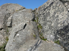
In a short distance I reached the first of several steep, rough pitches on the Cliff Walk, this one aided by a ladder.

The first ledge scramble. Note the white "C" marking the trail.

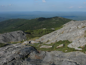
After a half-mile of climbing, I reached the first of several open viewpoints. This one is called Hello Rock, because when the old Halfway House was open partway up the mountain, hikers used to shout down to guests toiling up the road to the hotel. From here, the entire Wapack Range can be seen to the east.

Guests at the hotel built many short trails with quirky names, such as this one coming up behind the outlook.
 The Cliff Walk was a joy to hike, ducking in and out of spruce woods and out onto open ledge viewpoints.
 The next vista spot was named Point Surprise, because the view bursts out when you emerge from a dark forest grove. I'm guessing that the ledge seen in the little spruce patch in the center of the picture may be the outcrop whimsically named "The Matterhorn."
A view to the Pack Monadnocks (L) and Temple Mtn. (R).
 This ledge may be "Ainsworth's Seat," named for a local minister from the late 1700s.
At some junctions the trail directions are painted on the rocks.

Thoreau visited Monadnock four times and spent several nights encamped on its slopes. It's hard to say if he actually sat here and contemplated.


Just up the trail is Emerson's Seat. If Ralph W. were to return now, he wouldn't get much of a view. I'd say Ainsworth had the best seat in the house.

Another Cliff Walk scramble. Fun trail!

I made a short side trip on the Noble Trail to a ledge with a view up to the bare summit with its remarkable ripples of rock.

Back on the Cliff Walk, short side paths led to the Wolf Dens, a complex of rocks and crevices, and an old graphite mine that was worked around 1850. Apparently the miners used some of the rock fragments to create a crude causeway; the flakes of graphite were packed in kegs and rolled down to a road lower on the mountain.

The Cliff Walk ended at the Monadnock sub-peak known as Bald Rock, a great open viewpoint. The funny word inscribed on the rock may be a derivation of the Greek word for "bald."
 A fellow hiker was lounging and enjoying the wide view west across the Connecticut River valley to Vermont.
After he left, I went over to check out the spot. What a perch!

Across the slopes there was a good view of the cliff known as the Black Precipice.
 The signature view from Bald Rock is up to the summit of Monadnock. Quite an impressive pile of rock. Hard to believe it was all wooded before a couple of massive fires in the 1800s. Early accounts say that before the fires (the first one accidental, the second supposedly set by farmers to drive out wolves who took refuge in the debris from the first fire), Bald Rock was the only bare ledge spot on the mountain.

From Bald Rock I followed the Smith Connecting Link for a short way, then turned left on the scenic Amphitheater Trail, which led across some neat ledge outcrops. Note the tiny yellow blaze near the top of the ledge in the foreground.

The Amphitheater Trail dropped roughly to the top of the Black Precipice, where there was a wide view south.
 Down in front was the sub-peak called Monte Rosa.
I scrambled down to the brink for a look at some wild-looking ledges along the cliff.


A short jaunt led to the junction to the Smith Summit Trail. Of course I had to go up this trail, perhaps the least used of the routes leading to the summit.

The Smith Summit had its share of ledge scrambles.
 Much of this trail was on open ledges - an exhilarating climb!
 I followed the little white dots closely.
It was great to be above treeline in the evening sun.

This late in the day (almost 6:00 pm), there were only a handful of hikers still on the mountain.

Nearing the summit, I got my first views north, looking down at Pumpelly Ridge and out to Crotched Mtn. Unfortunately it was too hazy to see the Whites; the limit of visibility was Mt. Kearsarge.

The summit area is like a heaving sea of weather-beaten crags.

Near the top is a fun scramble up a thin gully.

The park staff has painted trail names on the ledges around the summit so people head down the correct route. This could be a tough area to navigate in the fog.

In a ledge next to the high point was a triangle etched by the U.S. Coastal Survey in 1861.
 Nearby was the more recent (1931) benchmark from the USGS.
 Among other carvings was an elevation marking.
The views stretched out in every direction - not mountainous, but vast.

I went back down by this new favorite trail.
 Next stop was Monte Rosa, named by Halfway House guests for its rosy hue at sunset.
At the foot of Monte Rosa was a projecting ledge named "The Tooth."

The ledges at the top of Monte Rosa, with Bald Rock in the background.
 A curiosity atop Monte Rosa is this weathervane.
 I went down the Monte Rosa Trail a short way, then the Fairy Spring Trail past the mossy spring. That path also led past the foundation of Fassett's Mountain House, a primitive hostelry that operated for a few years in the late 1850s.
 The last landmark for the day was the old Halfway House site, at 2100 ft. on the south slope. A hotel was located here for nearly 100 years, and its regular guests built countless trails on the nearby slopes and ridges. The hotel burned down in 1954, and the road that led to it was closed to public vehicle traffic in 1969. There's still a grassy clearing here, a pleasant spot for a rest break.
 From the opening there's a peek at the top of Monadnock.
There's also a view west, all the way out to Mt. Greylock in the Berkshires. I sat on a ledge and soaked this in for a few minutes, then hustled down the Old Toll Road and back across the Parker Trail, doing the last mile by headlamp. All in all, it was a hugely satisfying return to Monadnock. I'm looking forward to exploring more of its many historic, lightly-traveled trails.

No comments:
Post a Comment