A full day - and evening - adventure with Dan Newton and Friday, his
slide-climbing companion. A highlight was climbing the massive slide
triggered by Tropical Storm Irene in 2011.
Passing
through a beautiful hardwood glade at the entry into Tunnel Ravine, the
huge valley (and partly formed glacial cirque) on the NW side of Mt.
Moosilauke.
We
found a few traces of the old Tunnel Ravine Trail, opened by the
Dartmouth Outing Club around 1930 and abandoned in the late 1940s.
A scene along the sizable but nameless brook that drains the ravine.
Partway up the valley there is a preciptious sidehill in rough terrain on the south side of the valley. On a couple of trips in years past I had crossed the brook to the north side to avoid that very difficult traverse. Thanks to a massive blowdown - probably from the 2017 Halloween storm - the north side was no longer an option. As Dan noted, it's the "unpredictable" that makes for a true backcountry adventure.
The slow, careful up-and-over on the steep sidehill ate up an unexpected amount of time.
We dropped down to the base of the largest cascade in the ravine.
More devastation across the brook here.
Friday admires the cascade from above.
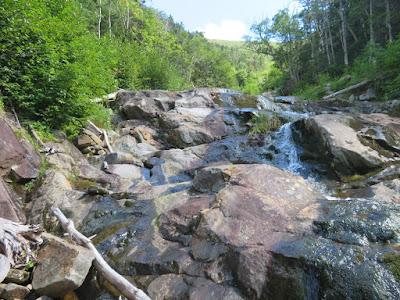
Another cascade farther up the ravine.
Deep in the valley are the collapsed remnants of the DOC Tunnel Ravine Shelter, built in 1930 and, like the trail, abandoned in the late 1940s.
This old arrow once pointed the way.
Ferny woods high on the floor of the ravine.
A happy bushwhacker hopping rocks up one of several dry sections of the brookbed.
Moose follow the brookbed, too.
A mossy confluence; might be an old slide track on the right.
Popping out onto the open brookbed approaching the Irene slide, with the headwall of the ravine in sight ahead.
The first of several sets of ledges to scale along the brookbed. Photo by Dan Newton.
Dan and Friday clamber up.
This set of ledges required careful foot placement to avoid the very slippery wet rock.
More ledges.
The wild scene at the foot of the Irene slide. In the middle is the main brook, tumbling down from the central headwall. On the right is the "footwall" of the Irene slide.
The footwall is steeper than it looks and dicey to climb. From a previous visit I knew the woods were miserable alongside it, but we opted for that route.
Oh boy.
There's Dan.
Dan and Friday made it out to the slide first.
Inseparable.
Looking up to the headwall.
Heading up.
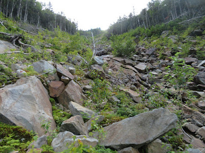
The slide stretches upward out of sight.
I visited the lower part of the slide in 2013, and in the intervening seven years revegetation has made significant progress. Haircap moss is flourishing in many spots on the slide.
What a day!
A natural at slide-climbing.
Approaching a rough ledgy section.
Friday takes a break.
Upward.
Down-look.
Looking up at a ledgy spot high on the headwall, the top of an old revegetated slide. Two weeks earlier I had bushwhacked from the Benton Trail to this perch for a clear view of the Irene slide.
The view of the slide from up there.
Almost like shingles on a roof.
Curving away below.
The trickiest scrambling on the slide, gotta trust your boots. The ledges on Moosilauke are composed of metamorphic rock known as the Littleton Formation, primarily schist - quite different from the igneous rock found on slides in the Sandwich Range and on Mt. Osceola.
Upper part of the slide.
Fine view to the NW.
We paused frequently to take in the scene.
Dan captures a close-up of haircap moss.
Looking up at Moosilauke's summit ridge.
The very top of the slide.
Friday takes it in.
Steep-walled Tunnel Ravine has been known for slide activity since the 1870s. The slide seen on the left fell in the mid-1980s. The light green swath to the right of center is the 1927 slide used as a route for the DOC Tunnel Ravine Trail. The track on the right is probably from a June 1973 storm.
The Irene slide in 2013, taken from a fir wave near the Benton Trail.
Exiting the top, at 4200 ft.
After a short, steep climb we reached the broad, gentle crest of Moosilauke's west ridge in a beautiful, fern-carpeted, moose-haunted boreal forest.
Likin' it when the "unpredictable" turns out in our favor.
We plotted our course to steer clear of Moosilauke's fragile alpine zone, and emerged from dense scrub farther south on the Carriage Road.
At our leisurely pace, it was six o' clock by the time we emerged above treeline on the Carriage Road, here looking back at South Peak.
A gorgeous evening.
Zoom on the dome of South Peak.
A special time to be above the trees.
Summit view of the White Mountain high peaks.
Looking SE down the Gorge Brook Trail.
Resting.
We had the summit to ourselves for our half-hour stay. It was clear enough to see all the Green Mountains and obtain glimpses of several Adirondack High Peaks.
We savored the stroll along the north ridge.
A burst of golden light on the sedges.
Our route home.
Near sunset from the west outlook on the Benton Trail. Scenes like this made it worth hiking the last two hours by headlamp.


Stunning! Many many thanks.
ReplyDeleteThank God for headlamps!
ReplyDeleteWe would have been in trouble without them!
Delete