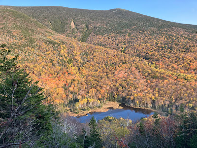
At any time of year, Tunnel Brook Notch, the deep gap between Mount Moosilauke and Mount Clough, is one of my favorite places in the White Mountains. It especially shines during foliage season. Much of the trail passes through hardwood forest, and the lower slopes within the notch surrounding the half-dozen beaver ponds are ablaze with color. Plus, it is removed from the foliage madness along the Kanc Highway and in the notches. My plan was to ascend partway up at least one of the nine slides on the steep east face of Mount Clough for views over the notch and the beaver ponds. I ended up enjoying outstanding views from two of the slides on a day that started out gloomy but turned into a gorgeous sunny October afternoon.
Golden walking along the southern approach on Tunnel Brook Trail.
A gray morning at Mud Pond. Moosilauke solidly socked in.
A birch log aids in the crossing of Tunnel Brook towards the north end of the beaver ponds.
A view of the two largest Clough slides from one of the northern beaver ponds. These are #4 and #5 of the nine, counting from the south. I planned to climb partway up the one on the left, #4, the highest and wildest of the bunch.
While bushwhacking to the base of slide #4, I passed by a train of boulders deposited alongside the runout, known as a debris flow levee.
There are three narrow spines of gravel and stones that were deposited at the base of the slide. This is the middle of the trio, with the steep, ledgy upper slide seen above.
Zoom on the upper slide, with red and white pines in the foreground. White pines are more commonly found on slides than red pines.
A lingering bit of red maple color.
These steep ledges were too wet and slick to climb.
Another rubbly section.
Reaching the ledgy upper half of the slide.
This is one of the steeper slide sections in the White Mountains, with excellent views down to the floor of the notch.
I navigated through some rugged terrain to a flat perch at 2650 ft. I arrived here late morning and settled in to wait for the predicted sunshine to materialize.
Looking promising.
Moosilauke's South Peak almost in the clear.
A coating of rime above ~4200 ft. It melted by early afternoon.
It is steep!
Looking up the upper ledges from my perch.
October glory.
I scrambled a little way above my perch on dry, pretty grippy rock.
Looking back at my perch.


Steve thanks for all the hiking blogs. I look forward to each report as I recover from a Peroneal tendon injury. (66 ole man, twisted my ankle while tracing the last Oct) love the photos make me feel like I am there.
ReplyDeleteThanks - glad you enjoy the reports and good luck with your recovery!
ReplyDelete