A late afternoon/evening hike up the Downes Brook Trail and a climb up the lower ledges of the Downes Brook (Passaconaway) Slide was a great way to beat the heat and the July 4th holiday crowds.
The drainages on the first 1.4 miles of the trail were in excellent shape thanks to the work of trail adopter Ken MacGray.
I never consider the four crossings of Downes Brook before the Wilderness boundary to be easy, but they were certainly manageable with the current low water flow.
Happy place.
Nice walkin'.
Deep woods of the Sandwich Range Wilderness.
Downes Brook near the foot of the slide.
Along the wooded lower track of the slide.
Granite steps.
A short bushwhack, partly along traces of
the historic, long-abandoned Downes Brook Slide Trail, brought me to
the expansive lower slabs of the vintage early 1890s slide. These are
prominent in the view of Mount Passaconaway from nearby Potash Mountain.
The ledges are slippery and dangerous when wet, which is
why the former trail that followed this route, dating back to the early 1900s, was closed by the USFS in
the late 1950s. Caution is needed to avoid stepping on wet areas of
ledge, which are slick as ice.
There are two colonies of Alpine Bulrush along the edge of the lower slabs. I don't believe I've seen these on a slide previously.
Side view of the gently sloping Conway Granite slabs (17 to 21 degrees), which are grippy when dry.
Summertime, and the livin' is easy. Sunshine on the slabs and a brook sliding down close by on the left. Potash Mountain rises across the valley.
View of Potash and its higher trailless neighbor, "South Potash."
More ledge steps.
Looking down the slabs. In his Passaconaway in the White Mountains (1916), Charles Edwards Beals, Jr. wrote: “The natives say that for a mile the rocks and boulders rolled with thunderous booming down the tiny brook-bed on that fateful November night in the early 1890s.”
Tiered cascade.
Looking down from the top of the cascade.
Another cascade, dropping into a golden pool.
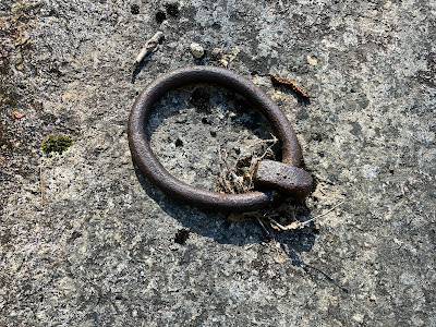
I continued up more slabs to the "Ring of Power," a relic of the Swift River Railroad logging days in the early 1900s. This was likely used to lower logs down the ledges with a cable.
This photo from the 1910s in the Appalachian Mountain Club archives shows a team of horses and men hauling a load of logs on the ledges of the slide, angling towards a tote road at the edge of the woods. The shapes of the ledges in this archival photo match those seen in the next photo below; this location is just a few yards downslope from the iron ring. The tote road towards which the horse team was heading can be seen on Lidar hillshade mapping.
Note the second of three protruding ledges to the right of center, which looks similar to the ledge in the archival photo.
Slanting light on slanting ledges.
A stark spruce forest borders the slide.
Meadowsweet, a frequent colonizer of slides.
Sedgy seam.


No comments:
Post a Comment