TECUMSEH RAPIDS & WHITTEN WOODS: 2/27/17
Carol and I enjoyed two short hikes today, the first in search of a "lost cascade" at the base of Mt. Tecumseh, the second at the new Whitten Woods conservation area in Ashland.
From the Livermore parking area we went a short distance up Tripoli Road, then snowshoe-bushwhacked up along Tecumseh Brook, and think we found what was once called "Tecumseh Rapids."
This was first mentioned in the July 1880 issue of "Appalachia," in which AMC tramper Webster Wells described the new trail up Mt. Tecumseh, which ascended the ridge on the north side of Tecumseh Brook. Wells wrote that a branch path, 1 3/8 mile from Greeley's inn (at the base of Snows Mountain), "leads out to a pretty cascade." This spot was shown as Tecumseh Rapids on the 1892 and 1904 editions of A.L. Goodrich's map of Waterville Valley (http://www.whitemountainhistory.org/uploads/1904_4Waterville_pdf.pdf) but seemed to be forgotten after that. The site of this cascade closely matches the location on the old map.
This small fractured wall is just downstream from the cascade.
Firm snow conditions made for great snowshoeing in the open hardwoods.
An interesting open spot along the brook.
Afterwards we drove down to Highland Street in Ashland to explore some new terrain at Whitten Woods and look for two recently placed geocaches. This 453-acre property was recently conserved in a cooperative effort by the Squam Lakes Conservation Society, New England Forestry Foundation, Squam Lakes Association and the Town of Ashland.
A wide logging road trail leads to a junction where routes diverge to two low "peaks."
We headed to the North Peak first, passing this vista towards the Squam Lakes.
Just before the summit there is a framed vista north to Sandwich Dome.
The trail makes a pleasant climb through oak forest.
Ledges and oaks adorn the summit of North Peak. Near here we found a geocache after a near hour-long search.
We returned to the junction and made the short climb to the open South Peak, with a fine vista north and east. Carol made a quick find of the geocache here.
The north view includes Sandwich Dome, the Squam Range and Mt. Whiteface.
To the east are Little and Big Squam Lakes, Red Hill, and the Ossipee Range.
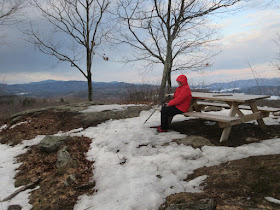
A picnic table sits atop the South Peak. The hike to both of these ~1150-ft. knolls is about 2 1/2 miles round trip with ~550 ft. of elevation gain. A longer loop is possible over North Peak. A nice new option for a short hike in the Lakes Region.


No comments:
Post a Comment