DOUBLEHEAD MOUNTAIN (SQUAM RANGE) : 6/27/11
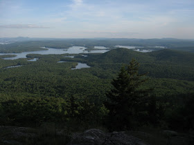
A late afternoon jaunt to one of the less-visited mountains in the Squam Range, the chain of low summits that stretches out on the NW side of Squam Lake. One could call this the "other" Doublehead, to distinguish it from its better-known namesake up in Jackson. Of its two summits, the east is the higher, coming in at 2158 ft. Both East and West Doublehead have limited summit views, but a little ways down from East is an open ledge with a great view over Squam Lake.
To hike the Doublehead Trail, you park out on Rt. 113 and head 0.9 mi. in on the gravel Thompson Rd. With my late start, I opted to ride (and in a couple of places, walk) my mountain bike in to the start of the hiking trail, which is marked by this sign.
 In its lower part the Doublehead Trail mostly follows various old logging roads. Typical of this area, there are also some old stone walls.
 This section of road runs through a parcel of conservation land owned by the Squam Lakes Conservation Society.
 Then the trail starts to climb more seriously, at first through some nice hardwood.
 The last half-mile up to the outlook ledge (at about 2030 ft.) is quite steep in places, and is a bit of a butt-kicker. The peaks of the Squam Range are low, but they can be deceptively difficult.
 It's worth it for the sweeping vista over Squam Lake, with its many coves, points and islands.
 Farther away are Lake Winnipesaukee and the Belknap Range.
Looking towards the Rattlesnakes, which are fully wooded on the back side.
 Looking SW along the Squam Range to Mt. Webster (L) and Mt. Morgan (R).
 Red Hill is prominent to the SE.
 The Ossipee Range sprawls to the ESE.
 After enjoying a leisurely evening meal on the ledge (if you can call a convenience store roast beef grinder a meal), I continued another 0.1 mi. up the Doublehead Trail to the ridgecrest and the Crawford-Ridgepole Trail.
 This 12-mi. route makes for a fine and surprisingly rugged day-long hike, with a car spot, from Sandwich Notch Rd. to the Cotton Mountain trailhead on Rt. 113 near Holderness.
 Just north of the summit of East Doublehead there is a ledgy spot with a partial view to the north: the Kinsmans, Welch-Dickey and Mt. Tecumseh.
 Evening at the summit of East Doublehead.
 My Doublehead trek wouldn't be complete without visiting both summits, so I descended to the deep wooded col on the Crawford-Ridgepole Trail...
 ...and made the short climb to the ledge at the summit of slightly lower West Doublehead.
 Another northern vista, this time with Sandwich Notch prominent in the foreground.
 On the way down, a parting shot of Squam from the view ledge. This is a nice short hike (4.6 mi. round trip, including the part on Thompson Rd.), and is much less popular than the busy Percival-Morgan circuit down the ridge.
You no longer ( 2016) have to park on 113; the road has been upgraded enough for my crv to pass, and at the trailhead there is now a parking area.
ReplyDeleteThanks for the update!
DeleteSteve