PROVINCE POND & MOUNT SHAW: 10/19/10
Province Pond is a small, boggy water body located in a quiet backcountry area on the eastern side of the White Mountains. The hike in to the pond on the Province Brook Trail, which is a wide snowmobile trail most of the way, is short and easy. Rising just W of the pond is a small range of trailless peaks that extend N from Mount Kearsarge North. Three of the summits in this range - Mt. Shaw (2585 ft.) and the Gemini, or Twins (North Peak, 2519 ft.; South Peak, 2490 ft.) can be seen from the shore of the pond. In the 1930s and 1940s a network of trails crisscrossed this ridge, but all except the trail to the pond have been abandoned for decades.
I had explored along this range several times in the 1990s, and was ready for a return visit, especially after spotting a prominent, bare fire scar on the shoulder of Mt. Shaw on a hike to Province Pond in 2006. To reach the trailhead, you drive 2.5 mi. up the gravel Peaked Hill Road. On my way in last Tuesday I had to stop to pull a few fallen limbs off the road.

There's only one destination shown on the trailhead sign: the shelter located on the N side of Province Pond.

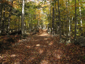
In the past the snowmobile trail part of the route was quite wet and muddy in places, but a recent upgrading of this old road in conjunction with the restoration of the dam at Province Pond has resulted in much drier footing. Tall hardwoods and hemlocks line the old road all the way in.
 At 1.2 mi., after crossing Province Brook on a snowmobile bridge, you reach the recently rebuilt and reseeded dam embankment at the S end of Province Pond.
 A new spillway was built in the middle of the embankment.
 Where the trail emerges by the edge of the embankment, there's a beautiful view of Mt. Shaw across the boggy southern half of the pond.
 You can't miss the fire scar on the E shoulder of the mountain.
 Looking N towards the shelter at the far end of the pond. There was surprisingly good foliage color here for this late in October.
 Partway along the shore, the narrow N section of the Province Brook Trail turns L off the snowmobile route. This junction is easily missed.
 The trail passes by a marvelous tent-shaped boulder, from the edge of which there is a good view of The Gemini, or Twins.
 Mt. Shaw and the shelter can also be seen from here.
 The trail meanders quite a ways back into the woods N of the pond, where in places it is hard to follow, then hooks back to the shelter. On several visits here I've never found the shelter occupied.
 The lean-to has a great southern exposure and a view across the water to little Peaked Hill (1755 ft.).
As part of the dam restoration project, an old rundown outhouse was removed, and replaced with this unique open-air throne and privacy screen.

From here I launched my bushwhack up Mt. Shaw, soon immersing myself in a sea of yellow hardwoods.
 Partway up I passed these interesting boulders.
Above the boulders there was a stand of massive hemlocks.

Other than the hemlocks, the route was just about 100% hardwoods, with a tall and colorful canopy.
 There were some large sugar maples in here as well.
Great hardwood whackin' on Mt. Shaw.
 After a steep pitch, at about 2200 ft. I came to the edge of the burned area. Dave Govatski, retired forester and fire officer from the WMNF, recalls that this fire was started by a lightning strike.

In 1990, on my first climb of Mt. Shaw, there was a stand of tall, dark spruce here, with a small but fine outlook at the edge of the cliff. Now the area is a large opening, strewn with bleached fallen tree trunks. A vigorous small growth of aspen is springing up through the debris.


It looked like a fire break had been cut at the back edge of the burn.

I picked my way down to the brink of the cliff.
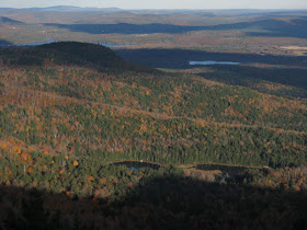
 Great eastern views here, on a spectacular October day. Province Pond is seen in the foreground with the Kimball Ponds and Pleasant Mountain in the distance.
 A closer look at Province Pond. The tent-shaped boulder on the shore can be seen on the L.
 Looking SE, with nice color in the basin below.
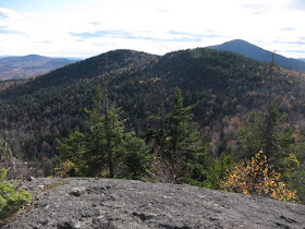
 The South Gemini rises nearby, with Black Cap Mountain in the distance.
 By poking around I found a good view NE to Speckled Mountain.
 The cliff of Red Rock Mountain is prominent on the ridge that extends E from Speckled.
 The views were so nice here I soaked up the sun for an hour and a half.
On the way up to the summit of Shaw, I came upon what appeared to be a trace of the old Mt. Shaw Trail along the ridgecrest.

The mixed woods here contained some fine old spruces.
 The summit ridge itself was cloaked in hardwoods, similar to many ridges in the Catskills.
 On the W slope was a deep, open spruce forest.
 There are several view ledges on the SE shoulder of Shaw. The most open ledge looks S to the Gemini and Kearsarge North.
 To the SW is an array of higher peaks in the southern and central Whites.
 The broad gap of Hancock Notch is prominent in this view of the Carrigain-Hancock-Huntington-Tremont area.
 The Sandwich Range beyond North Moat and Big Attitash.
 I decided to make a loop and descend via the Shaw-North Gemini col, with a possible side trip up North Gemini. Instead of following the curving ridgecrest, I opted for a more direct descent to the col. This proved to be a poor choice, with relentlessly rocky terrain making for slow going.
 A small pool in the col.
Though the hour was late, I decided to go for the 300-ft. climb up North Gemini. The route I chose was rather messy with blowdown and more boulders, and some patches of dense conifers.
 From previous visits I remembered a fine NE viewpoint near the top, and found it without too much trouble.
 The shadow of The Gemini approaches Province Pond.
 To the N, I could see the ledge I had just visited on the shoulder of Mt. Shaw.
 The actual summit of North Gemini is a viewless ledge.
 I took a more open route back down towards the North Gemini-Shaw col, and hit it a bit E of the height-of-land, at the very headwaters of Province Brook.
 The descent down the upper part of the basin was fairly thick with hobblebush and small conifers. Hurrying along, I took a whack from a hobblebush branch on my left eye, which is still bloodshot and Halloween-ready as I write this three days later. Lesson learned again: wear goggles or safety glasses when bushwhacking!
 The brook was my guide down the valley; occasionally I dipped down to have a look at it. The woods were much more open for the lower two-thirds of the descent.
 From the point where the brook empties into Province Pond, there is an extensive area of huge boulders in the woods leading S towards the dam embankment. With darkness drawing on, I opted for a route along the edge of the pond rather than negotiating the difficult boulder field. Once back on the wide Province Brook Trail, a near full moon helped me make it out without resorting to the headlamp.
Steve, thanks for sharing another of your marvelous adventures. You got some excellent photos, especially in the Province Pond area. As I mentioned to you a week or so ago, Cheri & went to Province Pond in conjunction with a shopping trip in North Conway. It was the first time we'd been there. It's an excellent little hike when you have only a few hours to spare! Or, as in your case, it's an excellent spot to visit and to use as a launch point for off-trail exploration of Mt. Shaw and the Gemini. And speaking of your off-trail exploration, best wishes for a speedy return to normal for that left eye that was "hobble-bushed"!
ReplyDeleteJohn
Thanks, John - it was the beautiful photo of the pond and Mt. Shaw that inspired me to go back to this interesting area.
ReplyDeleteSteve
That looks like a beautiful area, Steve - thank you for sharing this adventure! Got to love those open hardwoods!
ReplyDeleteThanks, Chris - it's a fun little range to explore.
ReplyDeleteSteve
Hi Steve, thanks for this blog entry. I love hikes like this. This is an area I'd like to explore in the near future. However, although I can find Province Pond easy enough on my maps, I am unable to locate the 'Peaked Hill Road' you mention in this entry. Would it happen to be FR 303 or FR 450 off of Green Hill Road?
ReplyDeleteHi Tobit,
ReplyDeleteThanks for reading! Province Pond is a wonderful destination. Peaked Hill Road is also FR 450. It probably won't be open to vehicles til Memorial Day, but it's not too bad of a walk in (2.6 miles each way). Enjoy it when you go!
Steve
Thanks Steve. This one is on the short list for us. - Greg
ReplyDeleteI did this hike today. It's a great destination. The area near the burn was super thick. My legs are pretty raw!
ReplyDeleteCool - I imagine it's a lot thicker after 5 1/2 more years of growth. It really is a neat area, glad you enjoyed it.
DeleteSteve
My Dad and I went up to the pond today after reading your blog. We are vacationing in the area. We really enjoyed the short hike. The pond is very peaceful. I'd love to come back when there is more color in the trees. I'd recommend this hike to anyone wanting to take a quick hike to enjoy what NH has to offer.
ReplyDeleteThanks for your comment - glad you enjoyed the pond!
DeleteSteve