The main reason anyone climbs North Weeks Mountain (3901 ft.) in the Pliny Range is its status as a peak on the New England Hundred Highest list. Its summit is broad, flat and very heavily wooded, with hardly the barest peek through the trees for a view.
As compensation for the lack of vistas, North Weeks (along with its Pliny Range neighbors, Middle Weeks, South Weeks and Mt. Waumbek) offers some of the most beautiful open, lichen-draped balsam fir forest of any White Mountain ridgecrest. This section of the Kilkenny Ridge Trail is one of the most enjoyable woods walks in the Whites.
A prominent and interesting feature of North Weeks is the ridge that juts out to the east from the summit, ending in a steep-sided 3553-ft. knob. This landform is visible from many places and has always intrigued this Kilkenny enthusiast. Here, it seemed, there would be hope for a view. From 1916 through 1966, the AMC White Mountain Guide contained this nugget in its brief description of what was originally Round Mountain and later became Mt. Weeks: "The summit is wooded, but about 1/2 m. to the E., from a spur which has been burned over, there is a view of the wilderness of the Upper Ammonoosuc region." Though it seemed likely a burn that old would be well-grown up, perhaps there would still be some peeks from the rim.
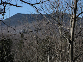
On a trip two winters ago I noticed some small open ledge patches on the NE flank of the knob, as seen in the view shown below from York Pond Road near the fish hatchery. And two weeks ago, from the Landing Camp Trail, I spotted another patch of ledge on the ESE side of the knob.
It was time for a visit to this knob, and on a cool, breezy morning with increasing sunshine, John Compton and I rendezvoused at the office for the Berlin Fish Hatchery, by the start of the Mill Brook Trail. First we checked in at the office upstairs on the status of the gate at the entrance to the hatchery. The man on duty told us that because there had recently been some vandalism on the property, the gate would often be closed at 4 pm, but left unlocked. Hikers who are planning to exit after 4 pm are advised to either check in at the office or call at 603-449-3412. The hatchery folks are very cooperative with hikers, knowing that this trailhead has seen a surge in usage since the Mt. Cabot Trail was closed by the landowner on the other side of the Pilot Range.
From the front of the office, we had a good view of our knobby objective, with the summit of North Weeks still kissed by a cloud.

The small parking area at York Pond Trail was full, so we parked a short distance up the road at the lot for the Unknown Pond Trail and walked back to the trailhead.

The first mile of York Pond Trail has easy grades. Soon after the junction with Bunnell Notch Trail you cross a brook on this bridge and small dam.
 A little farther along there are two brook crossings close together, potentially difficult in high water.
 There's a fairly long stretch through a swampy area, where the plank walkways were smothered by annual growth.
 Tis the season for interesting mushrooms.
 We found this little cascade a few yards off the trail.
 After a mile or so the trail starts to climb, and after passing a partly logged area we entered a nice hardwood forest.
As the trail climbs into Willard Notch - the broad gap between North Weeks and South Terrace - it leads through classic Kilkenny birch glades brimming with ferns.

 Near the height-of-land in Willard Notch we turned left onto the Kilkenny Ridge Trail.
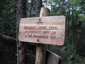
Beautiful woodlands rule on the Kilkenny Ridge Trail. Heading towards North Weeks, first you meander through a stand of tall, straight spruces.
 Higher up, a traverse leads past this ent-like old yellow birch.
Near here, a few yards off the trail, we admired a framed view of The Horn, the classic Kilkenny peak.

John admires a mossy boulder guarding the edge of the trail.
 Above 3100 ft. or so the KRT enters that beautiful open forest of old, lichen-draped balsam firs so typical of the Weeks peaks and Mt. Waumbek.
Somewhere around 3500 ft. we left the trail to bushwhack around to the E ridge. When I first did the three Weeks peaks in 1987 with two friends, a year or two before the KRT was completed, we enjoyed open woods bushwhacking nearly the whole way, the rare case of a whack being easier than expected. A term sometimes used for off-trail travel in parts of the Kilkenny is "fern-whacking." When John and I left the trail for the bushwhack to the E ridge, we encountered those same delightful conditions all the way to the knob, with only a few blowdown areas, and some places with potential leg-eating holes hidden under spongy turf. In these areas it is wise to tread carefully to prevent injury and minimize moss damage.
 John takes in the sylvan beauty along our route.
 The open woods were nearly continuous. After a while we determined that we had reached the broad E ridge and swung L to follow it, descending gently.
 At the base of the E knob was a flat area, still open woods.
 The short climb to the top of the knob was, as expected, through much thicker woods. We were not surprised to find that any views from the top of the knob were long gone.
John and I then fanned out looking for the ledge down on the NE side of the knob. It was slow going in steep, treacherous terrain. We caught a glimpse of it below, but an approach on the NW side was repulsed by a dead-end dropoff. We went back up and around; John proceeded farther SE and downhill to look for the other ledge on the ESE side of the knob. In the meantime, I wormed my way down, mostly on my butt, to a point where I could see the whitish NE ledge (shown in the lousy picture below).
 There was no safe way to get out on the ledge, but standing above it I obtained a clear view out to the NE over the valley of Brandy Brook - a fair reward for the effort. An interesting aspect of the vista was the broadside view of Deer Mountain and Deer Ridge.
 A zoom on the Deers, with York Pond and the fish hatchery buildings at the base of the ridge.
 Farther to the R, I could see Old Speck and its neighbors.
 After a break I re-established contact with John, who had found the ESE ledge farther down and across the steep slope.
 From one spot there was a view of the three Moriah peaks and North Carter beyond part of the Crescent Range.
 From the side of the ledge we found a nice framed vista of the Northern Presidentials and a cloud-capped Mt. Washington.
 The craggy scoop of King Ravine is always prominent in these Presidential views from the N.
 I was pleased to spot the beautiful meadow along the Upper Ammonoosuc River, a place my brother Drew and I had discovered near the end of the Landing Camp Trail a couple of weeks earlier.
 After enjoying these partial but very interesting views, we headed back up the face of the knob.
 We then contoured around the side of the knob, keeping the high point up to our R.
 Soon we were back into the great open woods, heading gently up the E ridge.
 We opted to continue directly up to the summit of North Weeks. In one section we skirted to the R of an extensive tree graveyard.
 The final climb to the summit was fairly steep, but the woods were still open.
 We hit the Kilkenny Ridge Trail a short distance N of this clearing, which marks the summit of North Weeks.
 A nearby campsite provides a nice spot for a break.
 On the way back down the KRT, we found this window view of Mt. Cabot right on the trail.
 More of that beautiful Weeks woods-walking.
 Evening light in Willard Notch.
 Jewelweed along the swampy lower section of York Pond Trail.
 The brook that parallels the trail.
The old log yard at the Bunnell Notch Trail junction was awash in goldenrod blooms.

Driving out, I stopped for a look at North Weeks and the E ridge and knob rising above York Pond - a nice end to an interesting exploration.


