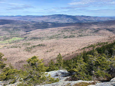
Continuing a series of wanderings along the mostly snow-free Appalachian Trail south of Mount Moosilauke, I hiked the Kodak Trail, the scenic route to 2909-ft. Mount Cube from the south. Few mountains under 3000 ft. offer the rewards of Cube, whose quartzite-capped summit rises east of the Connecticut River and SW of Mt. Moosilauke. It is part of the loosely affiliated range known as the Middle Connecticut River Mountains, and the Appalachian Trail traverses its crest. Both its south and north peaks sport spacious open ledges, providing completely different panoramas. In addition to enjoying these fine views, I made a bushwhack detour to a couple of interesting features along the way.
Parking is on gravel Quinttown Road just before a gate - the last short stretch of the road is rough.
The Kodak Trail (a segment of the Appalachian Trail) is reached by a 0.5 mile walk up the gravel road, part of the Thomson Tree Farm operation. As you approach a second gate, there is a peek at the Eastman Ledges, the first viewpoint encountered along the trail.
This sign has been in place for many years. The handwritten mileage to Mt. Cube Summit is the correct one. This name was applied by the Dartmouth Outing Club when it opened the trail in the late 1980s because a) the trail goes over the Eastman Ledges (get it?) and b) there are several "Kodak moments" from open ledges along the route.
Ascending to Eastman Ledges through fine hardwood forest.
Thousands of trout lily leaves were emerging. In another week or so the woods would be carpeted with their delicate yellow blooms.
It had been sunny and warm in Lincoln and Plymouth, but here the morning was gray and chilly, and the view of Smarts Mountain from the Eastman Ledges was obscured by clouds.
Curiously, the Killington Range was visible in the distance between Mousley and Stonehouse Mountains.
Beyond the viewpoint, the trail climbs past an impressive cliff hidden in the woods.
It then descends to cross the North Branch of Jacobs Brook. A nice cascade can be seen by descending 100 feet to the left down an old woods road.
To the right a beaten path leads 0.1 mile to an attractive beaver pond.
One of the residents was on patrol.
Farther along the trail I launched a bushwhack into wonderfully open hardwoods, traversing across Appalachian Trail corridor lands.
I passed through this interesting area where quartzite boulders were strewn amidst the forest.
Spring bushwhacking doesn't get any better.
A rock with character.
Quartz.
Approaching my first objective - a random ledge spotted on a satellite image.
At the top of this massive outcrop was a framed view of Smarts Mountain, which had emerged from the clouds.
A stiff climb led to the second off-trail objective, which appeared as an opening in the satellite image. It turned out to be a spectacular open fern glade.
The centerpiece of the glade is this picturesque birch. I took a long lunch break here on a log seat.
Looking back at the glade as I climbed the slope above.
Some incredibly rugged terrain rose above. I would not be going up that way to regain the trail.
I rejoined the trail in a very rugged and rocky section where it climbs to the next view ledges.
A rough quartzite highway.
A nice view of Smarts from the ledges above.
The woods are varied as the trail ascends the SW ridge of Cube.
The trail ascends this massive quartzite slab at 2550 ft. The ridgecrest quartzite of Cube is a hard metamorphic rock that is very resistant to erosion. These smooth ledges are slippery when wet, and even to some extent when dry.
Wide-open views here.
Snow lingered in only a few spots along the ridge.
The South Peak rising ahead, looking deceptively close. Still a half-mile to go.
Boreal forest on the upper part of the mountain.
The trail is badly eroded along the final push to the summit. In general, the footing on the trail was rougher than what I remembered from my last hike here in 2010. Part of that may be due to being 14 years older.
The view of Smarts Mountain, with its long, sweeping ridges, from the South Peak is one of my favorite vistas in the mountains.
A massive mountain is Smarts.
After taking a few photos I headed across to the North Peak, which is reached by a 0.3 mile side path off the Mount Cube Trail, the northward continuation of the AT.
The view from these ledges is completely different, gazing north to Mount Moosilauke beyond Upper Baker Pond.
Eastward is the sprawling mass of Carr Mountain, with Mount Osceola and the Sandwich Range in the distance to the left.
I returned to the South Peak for a sojourn in the recently revealed sun.
On the highest ledge a triangle inscribed in the 1870s by the U.S.
Coastal Survey is still clearly outlined - a testament to the erosion
resistance of the quartzite.
On the west side of the summit there are vast views across the Connecticut River valley into Vermont with the Green Mountains lining the horizon.
Springtime perfection.
Late afternoon sun in a glade of old yellow birches.
Junction with the side trail to Hexacuba Shelter. No time to visit today.
Climbing back to the Eastman Ledges.
Evening view of Smarts Mountain from the Eastman Ledges. The J Trail follows the long ridge in front.
Sunset glow beyond the foothills of Smarts.
Sundown in the hardwoods. The round trip to the South and North Peaks of Cube is 7.8 miles with about 2200 ft. of elevation gain.


No comments:
Post a Comment