Seeking to avoid the biting north wind on this cold late winter day, I headed into the sheltered Smarts Brook valley on the SW side of Sandwich Dome. After a quick bareboot approach on the hard-packed Old Waterville Road and Yellow Jacket Trail, I strapped on my snowshoes and turned onto the less-used, but still solidly packed, Smarts Brook Trail. In a short distance I took a brief tour out onto the Smarts Brook beaver pond/meadow for a view of the Black Mountain ridge, with the summit of Sandwich Dome just peeking outbehind a tree on the left.
The Smarts Brook Trail had a solid snowshoe track with just a wee bit of new snow on top, more in drifted areas.
Smarts Brook, just before the Wilderness boundary.
In we go.
I made a bushwhack diversion up a fine hardwood ridge on the Black Mountain (SE side) of the valley. I had some hope that firm snow conditions would enable me to make it up to the Smarts Brook Scar, an open patch from an old slide in a ravine on the flank of the 3500-ft. upper Black Mountain, which I had visited in summer two years ago. But it was not to be - the crust in the hardwoods was unreliable, allowing me to punch through every few steps, and there was no crust at all in the softwoods, only sugary snow. In the hardwoods I came across what looked like old moose tracks/postholes.
There are some magnificent sugar maples on this ridge, including this towering trio.
Impressive girth on this maple. The Smarts Brook valley was logged in the 1920s, though on three visits I've seen no old logging roads on this ridge.
Weaving up through the trees.
Battered but still standing tall.
Lichen layer cake.
An expansive stand of hardwoods.
The lower of the two Black Mountains looms close by to the south.
From the crest of the ridge I dropped northward back down through spruce forest to the trail, a half-mile farther up the valley from where I left it.
Through here I was sinking in with every step. Luckily the snow wasn't too deep.
Shortly after returning to the trail I came to the opening where you get a peek up at the cliffs of Sachem Peak across the valley.
In this section the Smarts Brook Trail runs along the slope high above the brook.
The forest in the upper valley is almost exclusively coniferous.
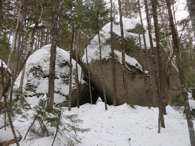
After the trail crosses Smarts Brook high up in the valley, it passes an assemblage of impressive large boulders.
This boulder cave is just to the left of the trail.
Shelter from the storm.
I wandered off a bit on the north side of the trail to look at more boulders.
This one had perhaps the most interesting shape.
On the way back, another look at the Sachem Peak cliffs. The Smarts Brook Trail is an excellent snowshoeing route, wild and secluded, with easy to moderate grades throughout. The trek out to the boulders is around 8 miles round trip with 1450 ft. of elevation gain.


No comments:
Post a Comment