
KETTLES-SCAUR RAMBLE: 3/25/11
With a half-day off, I returned to Waterville Valley for a favorite hike that has appeared a couple of times on this blog before: The Kettles and The Scaur, two interesting spots accessed by the nifty WVAIA trail network. I put a little different twist on it by bushwhacking up to The Scaur.
After an easy 0.9 mile on the groomed Livermore Trail, I exited onto the Kettles Path.

There was about 5 inches of snow atop the solid old track; it was getting a bit sticky in the sun.
 The first and smallest of the three Kettles is on the R. These depressions in the forest, left when stranded ice chunks from the continental glacier melted away, are much more visible in winter.
 I snowshoed down into the Kettle for a look around.
 Back up on the trail, I passed the second Kettle, on the L...
 ...and then the third and deepest Kettle on the R.
 Before reaching the junction with the Scaur Trail, I struck off into the open hardwoods. Bushwhacking conditions were superb, with a few inches of newer snow atop a very firm base.
 A great area for 'whackin'!
 Farther up the slope I could see the conifer tops up on The Scaur.
 The hardwoods marched right up to the base of The Scaur, where I got an interesting view of the ragged cliff on the face of this nubbly little peak.
 A wonderful old maple near the base of the ledges.
I skirted this ledge before the final push to the crest of the little ridge.
 At the top was a neat hardwood shelf, where I waited out a brief snow squall.
 Weathered old trees and changeable skies.
 At the end of the shelf was a marvelous ledge, a miniature Waterville version of the Rock of Gibraltar.
 I whacked across to the Scaur Trail and climbed the final steep pitch, where ice lurked beneath a thin veneer of snow.
 Regular readers of this blog know that this spot is a favorite of mine. For such an easy hike, it has a surprisingly extensive view of the Waterville backcountry, here looking south to the sprawling ridges of Sandwich Dome.
 Zooming in, you peer into the valley of Drakes Brook, guarded by Noon Peak on the R.
 Looking L, you see Middle and South Tripyramid and the wild country of the Lost Pass region.
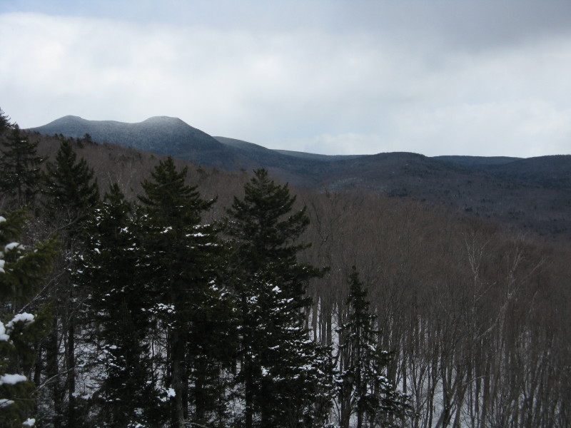 A closer look at Middle and South Tripyramid.
 Tecumseh is across the valley to the SW. No snow guns going today - too late in the season. There were a fair number of skiers out enjoying the excellent, near midwinter conditions.
 Looking down at the great hardwoods I came up through.
 Over on the L side I could see that big old maple down below.
 From a spot a few yards west of the open ledges, there was a framed vista of East Osceola and its remarkable Painted Cliff.
 For the descent, I retraced my bushwhack route, seeing that big rock from another angle.
 A winding track through the hardwoods.
 Some whooping was in order descending through these woods.
 Back on the Livermore Trail, where conditions looked quite good for X-C skiing.
 The Scaur is the ledgy bump seen on the L in this view from Depot Camp. I brought my GPS on this hike, and its elevation readings confirmed what I had suspected for some time: it appears that the contour lines in the vicinity of The Scaur are misplaced on the 7 1/2' USGS Mount Tripyramid quad.
 My barometric GPS altimeter read 1570 ft. at the Livermore Road trailhead, 2240 ft. on the "summit" of The Scaur, and 1580 ft. back at the trailhead. (The trailhead elevation in the White Mountain Guide, taken from the Waterville Valley quad, is 1580 ft.) The GPS-based altimeter had similar readings. I took a waypoint at the summit, which when placed on the USGS quad in a software program shows up at about 2130 ft., on the side of a slope. When you run the cursor over the ledges of The Scaur on Google Earth, it shows the same 2130 ft. elevation range. When you tilt it in Google Earth, it shows no relief on the ledges; makes them look flat. The problem, I assume, is with the underlying USGS dataset.
 On the bushwack to The Scaur, I traversed nearly level to the Scaur Trail, then climbed the last short, steep pitch on the trail to the top. The GPS track placed on the quad shows me going significantly DOWNHILL to the "summit." Where I think the top of The Scaur should be on the quad, terrain-wise, is some distance east of the waypoint, where the 2200 and 2240 ft. contours are close together.
On the 15' Mount Chocorua quad (1931 and 1958), The Scaur is depicted more accurately, as a knob with a 2220 ft. contour at the top.
This one is a head-scratcher!
This one is a head-scratcher!

Steve, that is indeed a nice trek! And, regarding your photos, I particularly like that framed vista of East Osceola and its striking Painted Cliff.
ReplyDeleteJohn
Hi John,
ReplyDeleteKettles-Scaur is one of my "comfort hikes " a very pleasant area and a surprisingly good view for such a little bump. The long ridge that runs east from The Scaur to Livermore Trail has open hardwoods on its south side nearly all the way across.
The Painted Cliff is unique, isn't it? Three of us once snowshoed up to the talus below it, but I don't know if I would repeat that - there were some scary boulder holes on the upper part of the approach.
Steve